Scientifically and legislatively, lakes are indistinguishable
from ponds, but lakes generally are considered to be longer and
deeper lentic, or still, waters. In the 18th and
19th centuries, scientists attempted to distinguish
the two more formally, stating that ponds were shallow enough to
allow sunlight to penetrate to the bottom, but this exists
today as an unofficial point.
Lake Havasu is a reservoir on the
Colorado River that
supplies water to the Colorado River
Aqueduct and Central Arizona Project. It is located at
the California/Arizona border, approximately 150 miles southeast
of Las Vegas, Nevada and 30 miles southeast of Needles,
California.
Situated in southwest Riverside County near the Santa Ana
Mountains – about 60 miles southeast of Los Angeles – Lake
Mathews is a
major reservoir in Southern California.
Lake Mead is the main reservoir formed by Hoover Dam on the border between
Southern Nevada and northwestern Arizona.
Created in the 1930s as part of Hoover Dam [see also Elwood Mead], Lake Mead provides
water storage in the Lower Basin of the Colorado River. The reservoir is
designed to hold 28,945,000 acre-feet of water and at 248
square miles its capacity is the largest in United States.
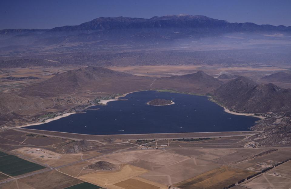
The State Water
Project facility Lake Perris, in northwestern Riverside
County, stores water for Inland Empire cities such as San
Bernardino and Riverside. [See also Santa Ana River.]
Built between 1970 and 1974, Lake Perris is the SWP’s
southernmost reservoir and is one of the most popular
recreational lakes in the system.
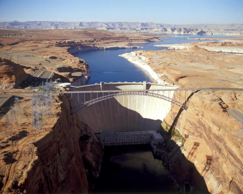
The construction of Glen Canyon Dam
in 1964 created Lake Powell. Both are located in north-central
Arizona near the Utah border. Lake Powell acts as a holding tank
for outflow from the Colorado River Upper Basin States: Colorado,
New Mexico, Utah and Wyoming.
The water stored in Lake Powell is used for recreation, power
generation and delivering water to the Lower Basin states of
California, Arizona, and Nevada.
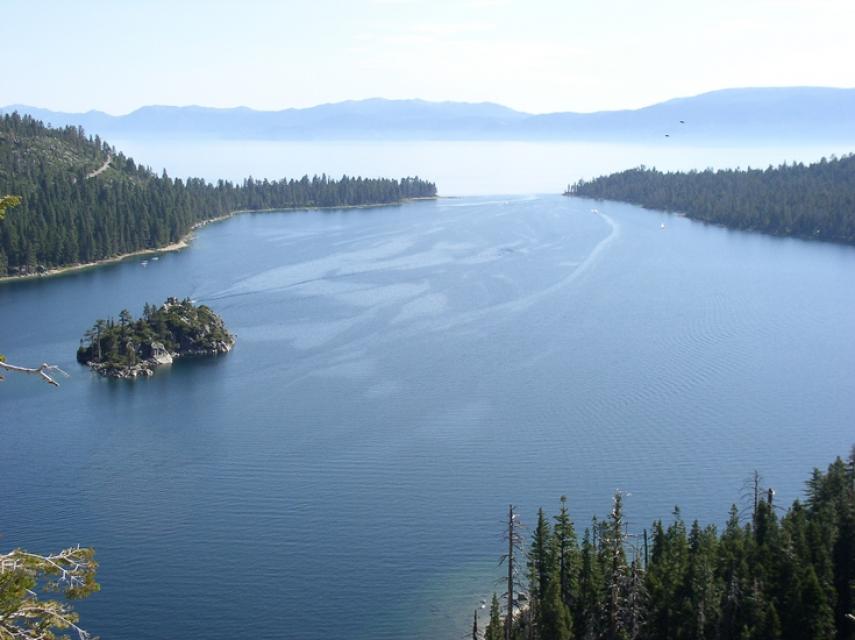
Lake Tahoe is one of the world’s most beautiful yet vulnerable
lakes. Renowned for its remarkable clarity, Tahoe straddles the
Nevada-California border, stretching 22 miles long and 12 miles
wide in a granitic bowl high in the Sierra Nevada.
Tahoe sits 6,225 feet above sea level. Its deepest point is 1,645
feet, making it the second-deepest lake in the nation, after
Oregon’s Crater Lake, and the tenth deepest in the world.
Land retirement is a practice that takes agricultural lands out
of production due to poor drainage and soils containing high
levels of salt and selenium (a mineral found in soil).
Typically, landowners are paid to retire land. The purchaser,
often a local water district, then places a deed restriction on
the land to prevent growing crops with irrigation water (a source
of salt). Growers in some cases may continue to farm using rain
water, a method known as dry farming.
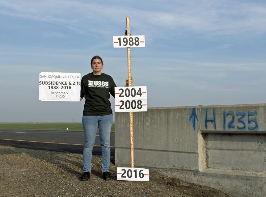
Land subsidence is the lowering of the land-surface elevation due
to changes that take place underground.
Throughout California, subsidence has damaged buildings,
aqueducts, well casings, bridges and highways. Common causes
include pumping water, oil or gas, dissolution of limestone
aquifers known as sinkholes, drainage of organic soils and
initial wetting of dry soils, according to the U.S. Geological
Survey.
The Landsat satellite program is a series of Earth-observing
satellite missions jointly managed by the National Aeronautics
and Space Administration and the U.S. Geological
Survey. Launched in 1972, Landsat is the longest
continuous global record of Earth observations. Landsat
data is used to evaluate agricultural production.
Lee Ferry on the Arizona-Utah border is a key dividing point
between the Colorado River’s Upper and Lower basins.
This split is important when it comes to determining how much
water will be delivered from the Upper Basin to the Lower Basin
[for a description of the Upper and Lower basins, visit the
Colorado River page].
California would not exist as it does today were it not for the
extensive system of levees, weirs and flood bypasses that have
been built through the years, particularly in the Sacramento-San Joaquin
Delta.
These levees have been in place dating back to 1850, when
California first joined the union.
The Los Angeles River is gradually being transformed from a
giant, trash-strewn stormwater channel to a recreational and open
space corridor that continues to provide flood control.
Deadly floods in the 1930s led the U.S. Army Corps of Engineers
to straighten and pave nearly all 52 miles of the river channel
in concrete. The trough was designed to keep flood water from
destroying property, to manage the discharges from sewage
treatment plants and to flush stormwater to the Pacific
Ocean.
Since the 1990s, a grassroots campaign to restore some of the
natural character of the river has gained political traction.


")

.")