Header link June 22, 2020

LinkedIn

  • Read more
Header link September 15, 2014

Cart

  • Read more
Header link November 3, 2015

Donate Now

  • Read more
Header link May 15, 2014

Twitter

  • Read more
Header link May 15, 2014

Facebook

  • Read more
Instagram
Header link May 15, 2014

Instagram

  • Read more
Header link May 15, 2014

Contact Us

  • Read more
More options
Water Education Foundation
Home

Water Education Foundation

Everything about California water that matters
  • Water Academy
    • Agriculture
      • Agricultural Conservation
      • Agricultural Drainage
    • Background Information
      • Legislation — California and Federal
      • Regulations — California and Federal
      • Water History
      • Water Rights
    • Bay-Delta
      • Bay Delta
      • Bay Delta Conservation Plan
      • Delta Issues
      • Delta Smelt
      • Sacramento San Joaquin Delta
      • San Francisco Bay
      • Suisun Marsh
    • Dams, Reservoirs and Water Projects
      • California Aqueduct
      • Central Valley Project
      • Folsom Dam
      • Friant Dam
      • Hetch Hetchy
      • Hoover Dam
      • Infrastructure
      • Lake Mead
      • Lake Powell
      • Oroville Dam
      • San Luis Dam
      • Shasta Dam
      • State Water Project
    • Environmental Issues
      • Anadromous Fish Restoration
      • Ecosystem
      • Endangered Species Act
      • Invasive species
      • Lake Tahoe
      • Mono Lake
      • Public Trust Doctrine
      • Salmon
      • San Joaquin River Restoration
      • Watershed
      • Wetlands
    • Leaders and Experts
    • Regions
      • Central Coast
      • Central Valley
      • Mexico
      • Nevada
      • North Coast
      • Pyramid Lake
      • Sacramento Valley
      • Salton Sea
      • San Joaquin Valley
      • Sierra Nevada
      • Southern California
      • Tulare Lake Basin
    • Rivers
      • Carson River
      • Colorado River
      • Klamath River
      • New River
      • North Coast Rivers
      • Russian River
      • Sacramento River
      • Truckee River
      • San Joaquin River
    • Water Issues
      • Climate Change
      • Coronavirus
      • Drought
      • Earthquakes
      • Energy and Water
      • Floods
      • Fracking
      • Growth
      • Hydropower
      • Levees
      • Tribal Water Issues
      • Water Conservation
      • Water Equity
    • Water Quality
      • Drinking Water
      • Nitrate contamination
      • Pollution
      • Stormwater
      • Wastewater
      • Water Quality
    • Water Supply and Management
      • Acre Foot
      • Aquifers
      • California Water Plan
      • Conjunctive Use
      • Desalination
      • Grey water
      • Groundwater
      • Integrated Regional Water Management
      • Recreation
      • Surface Water
      • Water Marketing and Banking
      • Water Rates
      • Water Recycling
      • Water Supply
      • Water Transfers
  • Tours & Events
    • Water Tours
      • 2023 Tour Sponsors
    • Events
    • Event Calendar
    • Past Tours & Events
      • Anne J. Schneider Fund Lecture Series
  • Specialized Programs
    • Water Leaders
      • Class Rosters
      • Yearly Class Reports
      • Your Alumni Network
      • Alumni Profiles
    • Project WET
      • Workshops
      • Special Workshops & Events
      • Supplementary Materials
      • California Content Standard Correlations
      • Facilitator's Trainings
      • Foundation School Programs
        • Elementary Programs
        • Secondary Programs
      • Water Kids
      • California Project WET Gazette
      • Gazette Archives
    • Colorado River Project
    • GRA Scholastic Fund Program
  • Maps & Guides
    • Maps & Posters
    • Layperson's Guides
    • Map & Guide Bundles
    • Books
    • Colorado River Materials
    • California Runoff Rundown
    • Other Publications
    • Water Awareness Materials
    • Downloadable Publications
    • Videos and DVDs
      • Video Clips
    • School Age Publications
    • Stickers
    • Free Programs and Publications
  • Newsroom
    • Western Water News
    • Aquafornia
      • About Aquafornia
    • Information Desk
    • Western Water Magazine Archive
      • Full Print Edition
      • Print Edition Excerpts
    • River Report Archive
  • Aquapedia
    • Alphabetical List of Subjects
      • A
      • B
      • C
      • D
      • E
      • F
      • G
      • H
      • I
      • J
      • K
      • L
      • M
      • N
      • O
      • P
      • Q
      • R
      • S
      • T
      • U
      • V
      • W
      • X
      • Y
      • Z
    • Historical Water People
    • Where Does My Water Come From?
      • Northern California
      • Sacramento
      • North Bay
      • South Bay
      • Central Valley
      • Los Angeles
      • Inland Empire
      • San Diego
      • All California Water Sources
    • Timelines
    • Videos
    • Image Gallery
    • Water Directory
      • Federal Agencies
      • State Agencies in California
      • Environmental Organizations
      • Other California Organizations
      • State and Federal Legislative Committees
      • Water Associations and Groups
      • Western States Water Agencies and Districts
    • Online Resources
    • Useful Acronyms
    • About Aquapedia
  • About
    • About Us
      • Board of Directors
      • Staff Biographies
      • Job Openings
    • Announcements
    • Support Our Mission
      • Become a Member
      • Donate in Honor/Memory
      • Donate to Aquapedia or Aquafornia
      • Shop Amazon
      • Planned Giving
    • Contact Us
Aquapedia background December 1, 2017 Layperson's Guide to Flood Management

Atmospheric Rivers

A massive 1986 Northern California flood near Marysville, north of Sacramento, caused the south levee of the Yuba River to breach, forcing thousands of residents to evacuate their homes.Atmospheric rivers are relatively narrow bands of moisture that ferry precipitation across the Pacific Ocean to the West Coast and are key to California’s water supply.

They are commonly referred to as the “Pineapple Express” because of their origins in tropical regions. While atmospheric rivers are necessary to keep California’s water reservoirs full, some of them are dangerous because the extreme rainfall and wind can cause catastrophic flooding and damage. Their presence has been likened to the West Coast version of the hurricane hazard posed to the southeastern United States.

At the extreme end of atmospheric rivers is a phenomenon deemed by the U.S. Geological Survey as ARkStorm, an event that is expected to occur only once every 1,000 years but with the potential to dump massive amounts of water and cause widespread flooding.

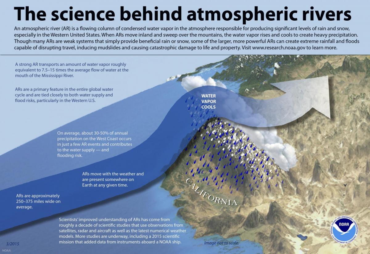
Typical atmospheric rivers are about 250 to 375 miles wide and are present somewhere on the planet at any given time. A strong atmospheric river transports an amount of water vapor roughly equivalent to as much as 15 times the average flow of the Mississippi River. Most atmospheric rivers are not disaster events and are critical to California because they deliver about half of the annual precipitation. For operators of flood management/water supply reservoirs, atmospheric rivers are challenging because the need to maintain enough storage space for incoming runoff means sometimes releasing valuable reservoir water that communities rely on during the dry summer months.

Because of this perception of “wasted” water, efforts are underway to sharpen forecast-based decisions so that unnecessary releases can be avoided. Current forecasts of atmospheric rivers are reliable out to about five days.

Improved understanding of atmospheric rivers has come from more than a decade of scientific studies using new satellite, radar, aircraft and other observational and computer-modeling improvements.

The Center for Western Weather and Water Extremes (CW3E), part of the Scripps Institution of Oceanography, is at the forefront of atmospheric rivers research. In 2020, CW3E launched a new sub-seasonal to seasonal forecasting tool to better predict the influence atmospheric rivers will have on the Western United States.

Meanwhile, the method known as Forecast-Informed Reservoir Operations (FIRO) aims to use the latest forecast technology to plan for the arrival of atmospheric rivers. California reservoirs such as Lake Mendocino in Mendocino County, Folsom Lake northeast of Sacramento and New Bullards Bar Reservoir northeast of Yuba City are using the method to retain as much water as possible during the short storm window.

  • Print-friendly

Referring Pages

Share this page

  • Share on Facebook
  • Share on Twitter
  • Share on LinkedIn
  • Sent to a friend.
Print-friendly

Related Links

Aquapedia background December 1, 2017 Layperson's Guide to Flood Management
Publication May 20, 2014

Layperson’s Guide to Flood Management
Updated 2009

The 24-page Layperson’s Guide to Flood Management explains the physical flood control system, including levees; discusses previous flood events (including the 1997 flooding); explores issues of floodplain management and development; provides an overview of flood forecasting; and outlines ongoing flood control projects. 

  • Read more
Back
This item appears in:
  • A
  • Topic: Floods
  • Topic: Water Supply
Footer pod May 20, 2014

Water Education Foundation

Copyright © 2023 Water Education Foundation. All rights reserved.

The Water Education Foundation is a nonprofit, tax-exempt, 501(c)3 organization, federal tax ID #942419885.

Privacy Policy

Donor Privacy Policy

  • Read more
Footer pod May 20, 2014

Contact Information

2151 River Plaza Drive, Suite 205
Sacramento CA 95833

Telephone (916) 444-6240

Contact Us via email

  • Read more

Quicklinks

Footer quicklink May 20, 2014

Contact Us

  • Read more
Footer quicklink May 20, 2014

Donate Today

  • Read more
Footer quicklink May 20, 2014

Tours

  • Read more
Footer quicklink May 20, 2014

Newsletter Signup

  • Read more
Footer quicklink May 20, 2014

Foundation News

  • Read more
Footer quicklink May 20, 2014

Calendar

  • Read more

Log in

  • Create new account
  • Request new password

Commands

  • Support portal
  • Log in