Header link June 22, 2020

LinkedIn

  • Read more
Header link September 15, 2014

Cart

  • Read more
Header link November 3, 2015

Donate Now

  • Read more
Header link May 15, 2014

Twitter

  • Read more
Header link May 15, 2014

Facebook

  • Read more
Instagram
Header link May 15, 2014

Instagram

  • Read more
Header link May 15, 2014

Contact Us

  • Read more
More options
Water Education Foundation
Home

Water Education Foundation

Everything about California water that matters
  • Water Academy
    • Agriculture
      • Agricultural Conservation
      • Agricultural Drainage
    • Background Information
      • Legislation — California and Federal
      • Regulations — California and Federal
      • Water History
      • Water Rights
    • Bay-Delta
      • Bay Delta
      • Bay Delta Conservation Plan
      • Delta Issues
      • Delta Smelt
      • Sacramento San Joaquin Delta
      • San Francisco Bay
      • Suisun Marsh
    • Dams, Reservoirs and Water Projects
      • California Aqueduct
      • Central Valley Project
      • Folsom Dam
      • Friant Dam
      • Hetch Hetchy
      • Hoover Dam
      • Infrastructure
      • Lake Mead
      • Lake Powell
      • Oroville Dam
      • San Luis Dam
      • Shasta Dam
      • State Water Project
    • Environmental Issues
      • Anadromous Fish Restoration
      • Ecosystem
      • Endangered Species Act
      • Invasive species
      • Lake Tahoe
      • Mono Lake
      • Public Trust Doctrine
      • Salmon
      • San Joaquin River Restoration
      • Watershed
      • Wetlands
    • Leaders and Experts
    • Regions
      • Central Coast
      • Central Valley
      • Mexico
      • Nevada
      • North Coast
      • Pyramid Lake
      • Sacramento Valley
      • Salton Sea
      • San Joaquin Valley
      • Sierra Nevada
      • Southern California
      • Tulare Lake Basin
    • Rivers
      • Carson River
      • Colorado River
      • Klamath River
      • New River
      • North Coast Rivers
      • Russian River
      • Sacramento River
      • Truckee River
      • San Joaquin River
    • Water Issues
      • Climate Change
      • Coronavirus
      • Drought
      • Earthquakes
      • Energy and Water
      • Floods
      • Fracking
      • Growth
      • Hydropower
      • Levees
      • Tribal Water Issues
      • Water Conservation
      • Water Equity
    • Water Quality
      • Drinking Water
      • Nitrate contamination
      • Pollution
      • Stormwater
      • Wastewater
      • Water Quality
    • Water Supply and Management
      • Acre Foot
      • Aquifers
      • California Water Plan
      • Conjunctive Use
      • Desalination
      • Grey water
      • Groundwater
      • Integrated Regional Water Management
      • Recreation
      • Surface Water
      • Water Marketing and Banking
      • Water Rates
      • Water Recycling
      • Water Supply
      • Water Transfers
  • Tours & Events
    • Water Tours
      • 2023 Tour Sponsors
    • Events
    • Event Calendar
    • Past Tours & Events
      • Anne J. Schneider Fund Lecture Series
  • Specialized Programs
    • Water Leaders
      • Class Rosters
      • Yearly Class Reports
      • Your Alumni Network
      • Alumni Profiles
    • Project WET
      • Workshops
      • Special Workshops & Events
      • Supplementary Materials
      • California Content Standard Correlations
      • Facilitator's Trainings
      • Foundation School Programs
        • Elementary Programs
        • Secondary Programs
      • Water Kids
      • California Project WET Gazette
      • Gazette Archives
    • Colorado River Project
    • GRA Scholastic Fund Program
  • Maps & Guides
    • Maps & Posters
    • Layperson's Guides
    • Map & Guide Bundles
    • Books
    • Colorado River Materials
    • California Runoff Rundown
    • Other Publications
    • Water Awareness Materials
    • Downloadable Publications
    • Videos and DVDs
      • Video Clips
    • School Age Publications
    • Stickers
    • Free Programs and Publications
  • Newsroom
    • Western Water News
    • Aquafornia
      • About Aquafornia
    • Information Desk
    • Western Water Magazine Archive
      • Full Print Edition
      • Print Edition Excerpts
    • River Report Archive
  • Aquapedia
    • Alphabetical List of Subjects
      • A
      • B
      • C
      • D
      • E
      • F
      • G
      • H
      • I
      • J
      • K
      • L
      • M
      • N
      • O
      • P
      • Q
      • R
      • S
      • T
      • U
      • V
      • W
      • X
      • Y
      • Z
    • Historical Water People
    • Where Does My Water Come From?
      • Northern California
      • Sacramento
      • North Bay
      • South Bay
      • Central Valley
      • Los Angeles
      • Inland Empire
      • San Diego
      • All California Water Sources
    • Timelines
    • Videos
    • Image Gallery
    • Water Directory
      • Federal Agencies
      • State Agencies in California
      • Environmental Organizations
      • Other California Organizations
      • State and Federal Legislative Committees
      • Water Associations and Groups
      • Western States Water Agencies and Districts
    • Online Resources
    • Useful Acronyms
    • About Aquapedia
  • About
    • About Us
      • Board of Directors
      • Staff Biographies
      • Job Openings
    • Announcements
    • Support Our Mission
      • Become a Member
      • Donate in Honor/Memory
      • Donate to Aquapedia or Aquafornia
      • Shop Amazon
      • Planned Giving
    • Contact Us
Aquapedia background February 14, 2014

Flood Forecasting

Flood Forecasting

Flood forecasting allows flood control managers to predict, with a high degree of accuracy, when local flooding is likely to take place.

Forecasts typically use storm runoff data, reservoir levels and releases to predict the rise in river levels.

In Northern California the National Weather Service, in cooperation with the state’s California-Nevada River Forecast Center in Sacramento, forecasts flooding.

Federal and state hydrologists can estimate high river stages within 12 to 24 hours before the event because of updates on weather, precipitation amounts, and reservoir and river levels. For example, two days before a powerful series of storms hit in 1997, forecasters predicted that 40 inches of rain would fall in the upper Feather River watershed, which was within 1 inch of the actual downpour.

On large, slower-moving rivers such as the Sacramento and San Joaquin, forecasters can predict high river stages more than 48 hours in advance because releases from upstream dams can take days to flow down the river. On smaller, faster-moving rivers, such as the Eel and Smith on the north coast of California, and most Southern California waterways, officials can produce accurate flood warnings no more than 12 hours ahead of time.

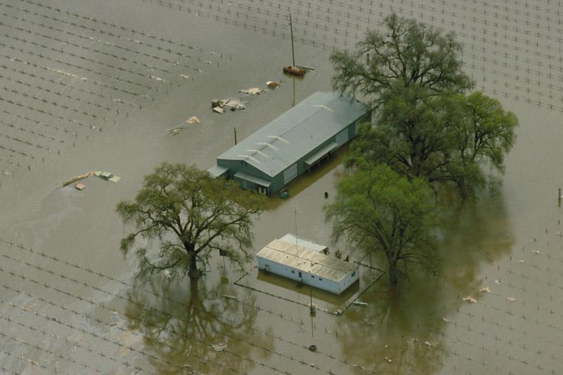
Flooding and Weather

Weather patterns arising from El Niño and La Niña weather conditions worry climatologists and flood managers.

El Niño refers to unusually warm currents along the coasts of Peru and Ecuador, which heat other parts of the ocean and atmosphere. This weather phenomenon can increase tropical water temperatures in the eastern Pacific and contribute to heavier and more frequent storms, particularly in Southern California, while in other spots it can cause drought.

La Niña, the inverse of El Niño, has a correlation to intense wet, warm storms and is caused by the interaction of cold surface ocean water near the equator and air.

Technological advances such as improved satellite and radar imagery also provide agencies with the means to anticipate storm surges and plan accordingly.

Looking ahead, earlier snow melt patterns because of warmer temperatures related to climate change may require new forecast bulletins in addition to the existing April-July water supply forecasts.

Such earlier melt times, greater precipitation variability and greater potential for direct storm runoff and the potential threat for major Sacramento-San Joaquin Delta levee failures caused by climate change-induced sea level rise when storms hit may challenge the current system of flood protection and water supply in the state.

  • Print-friendly

Referring Pages

Share this page

  • Share on Facebook
  • Share on Twitter
  • Share on LinkedIn
  • Sent to a friend.
Print-friendly

Related Links

Aquapedia background February 14, 2014
Back
This item appears in:
  • F
  • Topic: Floods
Footer pod May 20, 2014

Water Education Foundation

Copyright © 2023 Water Education Foundation. All rights reserved.

The Water Education Foundation is a nonprofit, tax-exempt, 501(c)3 organization, federal tax ID #942419885.

Privacy Policy

Donor Privacy Policy

  • Read more
Footer pod May 20, 2014

Contact Information

2151 River Plaza Drive, Suite 205
Sacramento CA 95833

Telephone (916) 444-6240

Contact Us via email

  • Read more

Quicklinks

Footer quicklink May 20, 2014

Contact Us

  • Read more
Footer quicklink May 20, 2014

Donate Today

  • Read more
Footer quicklink May 20, 2014

Tours

  • Read more
Footer quicklink May 20, 2014

Newsletter Signup

  • Read more
Footer quicklink May 20, 2014

Foundation News

  • Read more
Footer quicklink May 20, 2014

Calendar

  • Read more

Log in

  • Create new account
  • Request new password

Commands

  • Support portal
  • Log in