El Niño/La Niña
California’s seasonal weather is influenced by El Niño and La Niña – temporary climatic conditions that, depending on their severity, make the weather wetter or drier than normal.
El Niño and La Niña episodes typically last 9 to 12 months, but some may last for years. While their frequency can be quite irregular, El Niño and La Niña events occur on average every two to seven years. Typically, El Niño occurs more frequently than La Niña, according to the National Oceanic and Atmospheric Administration (NOAA).
El Niño
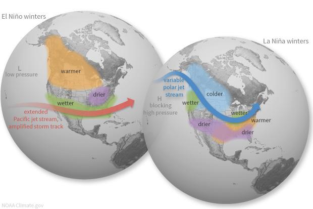
Although El Niño conditions can bring above-average precipitation to California in the winter, that is not always the case. Strong El Niño years, however, tend to bring wetter conditions in Northern California, helping to replenish key reservoirs for the State Water Project and the Central Valley Project that serve much of the state’s urban and agricultural regions.
El Niño is characterized by unusually warm water temperatures in the Pacific Ocean at the equator. Its storm track affects the location of jet streams. Instead of coming ashore in the Pacific Northwest, the southern jet stream hits California with increased rainfall that is typically accompanied by floods, landslides and coastal erosion. El Niño tends to make atmospheric rivers stronger. El Niño events in 1982-1983 and 1997-1998 drenched the West Coast with record rain. The El Niño in 2018-2019 was weak.
El Niño means “little boy” in Spanish, or in the context of Christmas, the Christ child, because of the time of year (around December) these warm-water events were historically observed off the coast of South America. El Niño is the warm phase of a larger phenomenon called the El Niño-Southern Oscillation, a periodic fluctuation in sea surface temperature and air pressure across the equatorial Pacific.
La Niña
La Niña, which means “little girl” in Spanish, is the opposite of El Niño, with a cooling of the ocean surface in the central and eastern tropical Pacific. La Niña winters typically result in dry conditions, particularly for Southern California.
La Niña results in colder ocean water off the West coast of the Americas, which pushes the jet stream north. In a La Niña winter, the storm track tends to hit the Pacific Northwest with heavier rain and flooding, sometimes dipping into Northern California. The American Southwest, meanwhile, is left drier than normal.
The colder water off the Pacific coast is more nutrient-rich and attracts more salmon, squid and other cold-water species to coastal California, according to NOAA.