Header link June 22, 2020

LinkedIn

  • Read more
Header link September 15, 2014

Cart

  • Read more
Header link November 3, 2015

Donate Now

  • Read more
Header link May 15, 2014

Twitter

  • Read more
Header link May 15, 2014

Facebook

  • Read more
Instagram
Header link May 15, 2014

Instagram

  • Read more
Header link May 15, 2014

Contact Us

  • Read more
More options
Water Education Foundation
Home
Water Education Foundation
Everything about California water that matters
  • Water Academy
    • Agriculture
      • Agricultural Conservation
      • Agricultural Drainage
    • Background Information
      • Legislation — California and Federal
      • Regulations — California and Federal
      • Water History
      • Water Rights
    • Bay-Delta
      • Bay Delta
      • Bay Delta Conservation Plan
      • Delta Issues
      • Delta Smelt
      • Sacramento San Joaquin Delta
      • San Francisco Bay
      • Suisun Marsh
    • Dams, Reservoirs and Water Projects
      • California Aqueduct
      • Central Valley Project
      • Folsom Dam
      • Friant Dam
      • Hetch Hetchy
      • Hoover Dam
      • Infrastructure
      • Lake Mead
      • Lake Powell
      • Oroville Dam
      • San Luis Dam
      • Shasta Dam
      • State Water Project
    • Environmental Issues
      • Anadromous Fish Restoration
      • Ecosystem
      • Endangered Species Act
      • Invasive species
      • Lake Tahoe
      • Mono Lake
      • Public Trust Doctrine
      • Salmon
      • San Joaquin River Restoration
      • Watershed
      • Wetlands
    • Leaders and Experts
    • Regions
      • Central Coast
      • Central Valley
      • Mexico
      • Nevada
      • North Coast
      • Pyramid Lake
      • Sacramento Valley
      • Salton Sea
      • San Joaquin Valley
      • Sierra Nevada
      • Southern California
      • Tulare Lake Basin
    • Rivers
      • Carson River
      • Colorado River
      • Klamath River
      • New River
      • North Coast Rivers
      • Russian River
      • Sacramento River
      • Truckee River
      • San Joaquin River
    • Water Issues
      • Climate Change
      • Coronavirus
      • Drought
      • Earthquakes
      • Energy and Water
      • Floods
      • Fracking
      • Growth
      • Hydropower
      • Levees
      • Tribal Water Issues
      • Water Conservation
    • Water Quality
      • Drinking Water
      • Nitrate contamination
      • Pollution
      • Stormwater
      • Wastewater
      • Water Quality
    • Water Supply and Management
      • Acre Foot
      • Aquifers
      • California Water Plan
      • Conjunctive Use
      • Desalination
      • Grey water
      • Groundwater
      • Integrated Regional Water Management
      • Recreation
      • Surface Water
      • Water Marketing and Banking
      • Water Rates
      • Water Recycling
      • Water Supply
      • Water Transfers
  • Tours & Events
    • Water Tours
      • 2024 Tour Sponsors
    • Events
    • Event Calendar
    • Past Tours & Events
      • Anne J. Schneider Fund Lecture Series
  • Specialized Programs
    • Water Leaders
      • Cohort Rosters
      • Yearly Class Reports
      • Your Alumni Network
      • Alumni Profiles
    • Project WET
      • Workshops
      • Special Workshops & Events
      • Supplementary Materials
      • California Content Standard Correlations
      • Facilitator's Trainings
      • Foundation School Programs
        • Elementary Programs
        • Secondary Programs
      • Water Kids
      • California Project WET Gazette
      • Gazette Archives
    • Colorado River Project
    • GRA Scholastic Fund Program
  • Maps & Guides
    • Maps & Posters
    • Layperson's Guides
    • Map & Guide Bundles
    • Books
    • Colorado River Materials
    • California Runoff Rundown
    • Other Publications
    • Water Awareness Materials
    • Downloadable Publications
    • Videos and DVDs
      • Video Clips
    • School Age Publications
    • Stickers
    • Free Programs and Publications
  • Newsroom
    • Western Water News
    • Aquafornia
      • About Aquafornia
    • Information Desk
    • Western Water Magazine Archive
      • Full Print Edition
      • Print Edition Excerpts
    • River Report Archive
  • Aquapedia
    • Alphabetical List of Subjects
      • A
      • B
      • C
      • D
      • E
      • F
      • G
      • H
      • I
      • J
      • K
      • L
      • M
      • N
      • O
      • P
      • Q
      • R
      • S
      • T
      • U
      • V
      • W
      • X
      • Y
      • Z
    • Historical Water People
    • Where Does My Water Come From?
      • Northern California
      • Sacramento
      • North Bay
      • South Bay
      • Central Valley
      • Los Angeles
      • Inland Empire
      • San Diego
      • All California Water Sources
    • Timelines
    • Videos
    • Image Gallery
    • Water Directory
      • Federal Agencies
      • State Agencies in California
      • Environmental Organizations
      • Other California Organizations
      • State and Federal Legislative Committees
      • Water Associations and Groups
      • Western States Water Agencies and Districts
    • Online Resources
    • Useful Acronyms
    • About Aquapedia
  • About
    • About Us
      • Board of Directors
      • Staff Biographies
      • Job Openings
    • Announcements
    • Support Our Mission
      • Become a Member
      • Donate in Honor/Memory
      • Planned Giving
    • Contact Us

Topic: Pyramid Lake

Overview April 24, 2014

Pyramid Lake

Pyramid Lake in Nevada has long been a focal point in a tug-of-war between water stakeholders. There’s been a struggle for water in this arid land among the American Indians, farmers, cities, environmentalists and the people of Nevada and California. The lake is the site of the nation’s first reclamation project and the subsequent struggles among Nevada farmers, the Paiute Indian Tribe and the growing city of Reno over use of the lake’s water. In 1990 a settlement act attempted to resolve some of these competing uses.

  • Read more
Announcement July 10, 2019

Explore a Scenic But Challenged California Landscape on Our Edge of Drought Tour
August 27-29 Tour Examines Santa Barbara Region Prone to Drought, Mudslides and Wildfire

Pyramid LakeNew to this year’s slate of water tours, our Edge of Drought Tour Aug. 27-29 will venture into the Santa Barbara area to learn about the challenges of limited local surface and groundwater supplies and the solutions being implemented to address them.

Despite Santa Barbara County’s decision to lift a drought emergency declaration after this winter’s storms replenished local reservoirs, the region’s hydrologic recovery often has lagged behind much of the rest of the state.

  • Read more
Video May 27, 2014

A Climate of Change: Water Adaptation Strategies

This 25-minute documentary-style DVD, developed in partnership with the California Department of Water Resources, provides an excellent overview of climate change and how it is already affecting California. The DVD also explains what scientists anticipate in the future related to sea level rise and precipitation/runoff changes and explores the efforts that are underway to plan and adapt to climate.

  • Read more
Maps & Posters May 20, 2014

Truckee River Basin Map
Published 2005

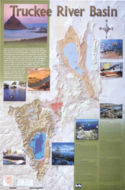
This beautiful 24×36-inch poster, suitable for framing, displays the rivers, lakes and reservoirs, irrigated farmland, urban areas and Indian reservations within the Truckee River Basin, including the Newlands Project, Pyramid Lake and Lake Tahoe. Map text explains the issues surrounding the use of the Truckee-Carson rivers, Lake Tahoe water quality improvement efforts, fishery restoration and the effort to reach compromise solutions to many of these issues. 

  • Read more
Maps & Posters May 20, 2014

Nevada Water Map
Published 2004

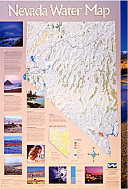
This 24×36 inch poster, suitable for framing, illustrates the water resources available for Nevada cities, agriculture and the environment. It features natural and manmade water resources throughout the state, including the Truckee and Carson rivers, Lake Tahoe, Pyramid Lake and the course of the Colorado River that forms the state’s eastern boundary.

  • Read more
Maps & Posters April 17, 2014 California Water Bundle

California Water Map
Updated December 2016

A new look for our most popular product! And it’s the perfect gift for the water wonk in your life.

Our 24×36-inch California Water Map is widely known for being the definitive poster that shows the integral role water plays in the state. On this updated version, it is easier to see California’s natural waterways and man-made reservoirs and aqueducts – including federally, state and locally funded projects – the wild and scenic rivers system, and natural lakes. The map features beautiful photos of California’s natural environment, rivers, water projects, wildlife, and urban and agricultural uses and the text focuses on key issues: water supply, water use, water projects, the Delta, wild and scenic rivers and the Colorado River.

  • Read more
Western Water Excerpt January 1, 2005 Sue McClurgRita Schmidt Sudman

Remnants of the Past: Management Challenges of Terminal Lakes
Jan/Feb 2005

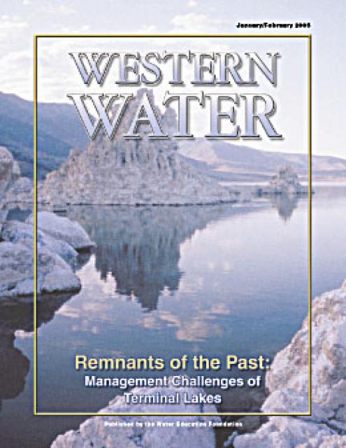
They are remnants of another time. A time when the Southwest’s climate was much cooler and probably wetter, and large lakes covered vast tracts of land in Nevada, Utah, southeastern Oregon and California’s Eastern Sierra. Beginning some 14,000 years ago, the region’s climate grew warmer and drier, shrinking these lakes’ shorelines and leaving behind an arid landscape dotted with isolated bodies of water including Pyramid Lake, Mono Lake and the Great Salt Lake.

  • Read more
Western Water Magazine January 1, 2004

Remnants of the Past: Management Challenges of Terminal Lakes
January/February 2005

This issue of Western Water examines the challenges facing state, federal and tribal officials and other stakeholders as they work to manage terminal lakes. It includes background information on the formation of these lakes, and overviews of the water quality, habitat and political issues surrounding these distinctive bodies of water. Much of the information in this article originated at the September 2004 StateManagement Issues at Terminal Water Bodies/Closed Basins conference.

  • Read more

Water Academy

  • Agriculture
  • Background Information
  • Bay-Delta
  • Dams, Reservoirs and Water Projects
  • Environmental Issues
  • Leaders and Experts
  • Regions
    • Central Coast
    • Central Valley
    • Mexico
    • Nevada
    • North Coast
    • Pyramid Lake
    • Sacramento Valley
    • Salton Sea
    • San Joaquin Valley
    • Sierra Nevada
    • Southern California
    • Tulare Lake Basin
  • Rivers
  • Water Issues
  • Water Quality
  • Water Supply and Management
Footer pod May 20, 2014

Water Education Foundation

Copyright © 2025 Water Education Foundation. All rights reserved.

The Water Education Foundation is a nonprofit, tax-exempt, 501(c)3 organization, federal tax ID #942419885.

Privacy Policy

Donor Privacy Policy

  • Read more
Footer pod May 20, 2014

Contact Information

2151 River Plaza Drive, Suite 205
Sacramento CA 95833

Telephone (916) 444-6240

Contact Us via email

  • Read more

Quicklinks

Footer quicklink May 20, 2014

Contact Us

  • Read more
Footer quicklink May 20, 2014

Donate Today

  • Read more
Footer quicklink May 20, 2014

Tours

  • Read more
Footer quicklink May 20, 2014

Newsletter Signup

  • Read more
Footer quicklink May 20, 2014

Foundation News

  • Read more
Footer quicklink May 20, 2014

Calendar

  • Read more

Log in

  • Create new account
  • Request new password

Commands

  • Support portal
  • Log in