Header link June 22, 2020

LinkedIn

  • Read more
Header link September 15, 2014

Cart

  • Read more
Header link November 3, 2015

Donate Now

  • Read more
Header link May 15, 2014

Twitter

  • Read more
Header link May 15, 2014

Facebook

  • Read more
Instagram
Header link May 15, 2014

Instagram

  • Read more
Header link May 15, 2014

Contact Us

  • Read more
More options
Water Education Foundation
Home

Water Education Foundation

Everything about California water that matters
  • Water Academy
    • Agriculture
      • Agricultural Conservation
      • Agricultural Drainage
    • Background Information
      • Legislation — California and Federal
      • Regulations — California and Federal
      • Water History
      • Water Rights
    • Bay-Delta
      • Bay Delta
      • Bay Delta Conservation Plan
      • Delta Issues
      • Delta Smelt
      • Sacramento San Joaquin Delta
      • San Francisco Bay
      • Suisun Marsh
    • Dams, Reservoirs and Water Projects
      • California Aqueduct
      • Central Valley Project
      • Folsom Dam
      • Friant Dam
      • Hetch Hetchy
      • Hoover Dam
      • Infrastructure
      • Lake Mead
      • Lake Powell
      • Oroville Dam
      • San Luis Dam
      • Shasta Dam
      • State Water Project
    • Environmental Issues
      • Anadromous Fish Restoration
      • Ecosystem
      • Endangered Species Act
      • Invasive species
      • Lake Tahoe
      • Mono Lake
      • Public Trust Doctrine
      • Salmon
      • San Joaquin River Restoration
      • Watershed
      • Wetlands
    • Leaders and Experts
    • Regions
      • Central Coast
      • Central Valley
      • Mexico
      • Nevada
      • North Coast
      • Pyramid Lake
      • Sacramento Valley
      • Salton Sea
      • San Joaquin Valley
      • Sierra Nevada
      • Southern California
      • Tulare Lake Basin
    • Rivers
      • Carson River
      • Colorado River
      • Klamath River
      • New River
      • North Coast Rivers
      • Russian River
      • Sacramento River
      • Truckee River
      • San Joaquin River
    • Water Issues
      • Climate Change
      • Coronavirus
      • Drought
      • Earthquakes
      • Energy and Water
      • Floods
      • Fracking
      • Growth
      • Hydropower
      • Levees
      • Tribal Water Issues
      • Water Conservation
    • Water Quality
      • Drinking Water
      • Nitrate contamination
      • Pollution
      • Stormwater
      • Wastewater
      • Water Quality
    • Water Supply and Management
      • Acre Foot
      • Aquifers
      • California Water Plan
      • Conjunctive Use
      • Desalination
      • Grey water
      • Groundwater
      • Integrated Regional Water Management
      • Recreation
      • Surface Water
      • Water Marketing and Banking
      • Water Rates
      • Water Recycling
      • Water Supply
      • Water Transfers
  • Tours & Events
    • Water Tours
      • 2024 Tour Sponsors
    • Events
    • Event Calendar
    • Past Tours & Events
      • Anne J. Schneider Fund Lecture Series
  • Specialized Programs
    • Water Leaders
      • Cohort Rosters
      • Yearly Class Reports
      • Your Alumni Network
      • Alumni Profiles
    • Project WET
      • Workshops
      • Special Workshops & Events
      • Supplementary Materials
      • California Content Standard Correlations
      • Facilitator's Trainings
      • Foundation School Programs
        • Elementary Programs
        • Secondary Programs
      • Water Kids
      • California Project WET Gazette
      • Gazette Archives
    • Colorado River Project
    • GRA Scholastic Fund Program
  • Maps & Guides
    • Maps & Posters
    • Layperson's Guides
    • Map & Guide Bundles
    • Books
    • Colorado River Materials
    • California Runoff Rundown
    • Other Publications
    • Water Awareness Materials
    • Downloadable Publications
    • Videos and DVDs
      • Video Clips
    • School Age Publications
    • Stickers
    • Free Programs and Publications
  • Newsroom
    • Western Water News
    • Aquafornia
      • About Aquafornia
    • Information Desk
    • Western Water Magazine Archive
      • Full Print Edition
      • Print Edition Excerpts
    • River Report Archive
  • Aquapedia
    • Alphabetical List of Subjects
      • A
      • B
      • C
      • D
      • E
      • F
      • G
      • H
      • I
      • J
      • K
      • L
      • M
      • N
      • O
      • P
      • Q
      • R
      • S
      • T
      • U
      • V
      • W
      • X
      • Y
      • Z
    • Historical Water People
    • Where Does My Water Come From?
      • Northern California
      • Sacramento
      • North Bay
      • South Bay
      • Central Valley
      • Los Angeles
      • Inland Empire
      • San Diego
      • All California Water Sources
    • Timelines
    • Videos
    • Image Gallery
    • Water Directory
      • Federal Agencies
      • State Agencies in California
      • Environmental Organizations
      • Other California Organizations
      • State and Federal Legislative Committees
      • Water Associations and Groups
      • Western States Water Agencies and Districts
    • Online Resources
    • Useful Acronyms
    • About Aquapedia
  • About
    • About Us
      • Board of Directors
      • Staff Biographies
      • Job Openings
    • Announcements
    • Support Our Mission
      • Become a Member
      • Donate in Honor/Memory
      • Planned Giving
    • Contact Us
Publication March 4, 2024 Colorado River Basin Map

Layperson’s Guide to the Colorado River Basin
Updated 2024

Cover of Layperson's Guide to the Colorado River Basin

Learn the history and challenges facing the West’s most dramatic and developed river. 

The Layperson’s Guide to the Colorado River Basin introduces the 1,450-mile river that sustains 40 million people and millions of acres of farmland spanning seven states and parts of northern Mexico.

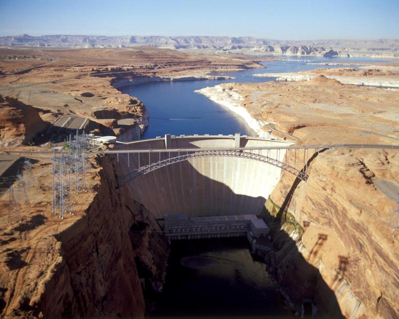
The 28-page primer explains how the river’s water is shared and managed as the Southwest transitions to a hotter and drier climate.

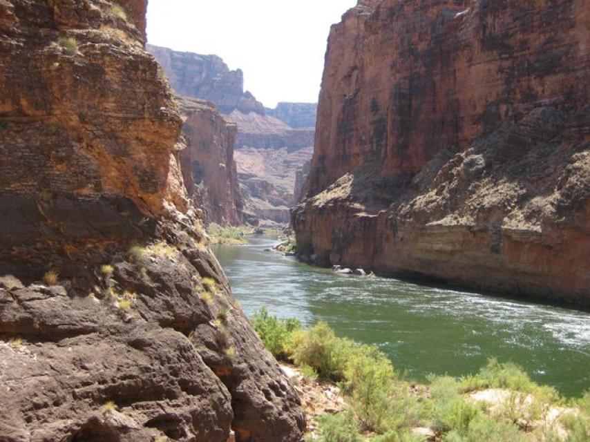
The guide covers the agricultural, tribal, environmental and recreational interests tied to the Colorado as it gushes from the Rocky Mountains, carves through the Grand Canyon and trickles toward the Gulf of California.

Our poster-size Colorado River Water Map complements the guide. You can get a discount on the map and guide when you buy the Colorado River Bundle. 

  • Print-friendly

Referring Pages

E-mail blast May 19, 2025 Layperson's Guide to the Colorado River Basin Colorado River Basin Map

AQUAFORNIA KICKOFF-Democrats Slam Army Corps Funding Cuts; Trump To Slash $600M For Critical Utah Water Project

In today’s Aquafornia scroll:

  • Read more
Western Water August 22, 2024 Colorado River Basin Map Layperson's Guide to the Colorado River Basin WESTERN WATER: Solar-Paneled Canopies over Canals Catching on in Southwest Alastair Bland

Solar-Paneled Canopies over Canals Catching on in Southwest
WESTERN WATER NOTEBOOK: Photovoltaic Shades Cut Evaporative Losses, Produce Clean Electricity

Over-canal solar system on Gila River Indian Community land near PhoenixAn intensifying but unseen force is stealing precious water from rivers in the arid West, but it’s hardly a thief in the night.

The midday sun is one of the more aggressive guzzlers of the Colorado River. Between its high Rockies headwaters and its Sonoran Desert delta, 1 to 2 million acre-feet of water evaporates each year in the Colorado River Basin. That’s a big gulp in a watershed where seven thirsty U.S. states and northern Mexico skirmish for their share of an overallocated, shrinking water supply. And the evaporation will only increase as the Southwest grows hotter and drier.

  • Read more
Aquapedia background February 11, 2014 Colorado River Basin Map Layperson's Guide to the Colorado River Basin

Quantification Settlement Agreement

Lining the All-American Canal

The Quantification Settlement Agreement (QSA), signed in 2003, defined the rights to a portion of Colorado River water for the San Diego County Water Authority, Coachella Valley Water District, Imperial Irrigation District and the Metropolitan Water District of Southern California.

The QSA responded to California consistently using more than its annual Colorado River entitlement of 4.4 million acre-feet. Additionally, the water needs of six other Colorado River Basin states had grown, making the river’s shared use increasingly crucial.

  • Read more
Aquapedia background February 11, 2014 Layperson's Guide to the Colorado River Basin Colorado River Basin Map

Lower Colorado River Multispecies Conservation Program

Humpback chub

In 2005, the Interior Department launched a program to recover 27 species in the lower Colorado River, including seven the federal government has deemed threatened or endangered or threatened with extinction. The species include fish, birds, bats, mammals, insects, amphibians, reptiles, rodents and plants

The Lower Colorado River Multispecies Conservation Program has a 50-year plan to create at least 8,132 acres of new habitat and restore habitat that has become degraded.

  • Read more
Aquapedia background February 10, 2014 Colorado River Basin Map Layperson's Guide to the Colorado River Basin

Imperial Valley

Imperial ValleyThe Imperial Valley in the southeastern corner of California receives the Colorado River Basin’s single-largest share of water to support much of the nation’s fruit and vegetable supply and hay for the
cattle and dairy industries.

  • Read more
Aquapedia background January 30, 2014 Colorado River Basin Map Layperson's Guide to the Colorado River Basin Layperson's Guide to the Colorado River Delta

Colorado River

Colorado RiverThe turbulent Colorado River is one of the most heavily regulated and hardest working rivers in the world.

Geography

The Colorado falls some 10,000 feet on its way from the Rocky Mountains to the Gulf of California, helping to sustain a range of habitats and ecosystems as it weaves through mountains and deserts.

  • Read more
  • Colorado River Timeline

Share this page

  • Share on Facebook
  • Share on Twitter
  • Share on LinkedIn
  • Sent to a friend.
Print-friendly

Related Links

Publication March 4, 2024 Colorado River Basin Map
Maps & Posters May 20, 2014

Colorado River Basin Map
Redesigned in 2017

Redesigned in 2017, this beautiful map depicts the seven Western states that share the Colorado River with Mexico. The Colorado River supplies water to nearly 40 million people in Arizona, California, Colorado, Nevada, New Mexico, Utah, Wyoming and Mexico. Text on this beautiful, 24×36-inch map, which is suitable for framing, explains the river’s apportionment, history and the need to adapt its management for urban growth and expected climate change impacts.

  • Read more
Back
This item appears in:
  • Topic: Climate Change
  • Layperson's Guides
  • Topic: Colorado River
  • Topic: Drought
  • Topic: Endangered Species Act
  • Topic: Mexico
  • Topic: Water History
  • Topic: Nevada
  • Topic: Water Rights
  • Topic: Energy and Water
  • Colorado River Materials
  • Topic: Hoover Dam
  • Topic: Salton Sea
  • Topic: Water Quality
  • Topic: Lake Mead
  • Topic: Lake Powell
  • Topic: Surface Water
  • Topic: Southern California
  • Topic: Tribal Water Issues
  • Topic: Water Conservation
  • Topic: Water Supply
  • Topic: Water Transfers
Footer pod May 20, 2014

Water Education Foundation

Copyright © 2025 Water Education Foundation. All rights reserved.

The Water Education Foundation is a nonprofit, tax-exempt, 501(c)3 organization, federal tax ID #942419885.

Privacy Policy

Donor Privacy Policy

  • Read more
Footer pod May 20, 2014

Contact Information

2151 River Plaza Drive, Suite 205
Sacramento CA 95833

Telephone (916) 444-6240

Contact Us via email

  • Read more

Quicklinks

Footer quicklink May 20, 2014

Contact Us

  • Read more
Footer quicklink May 20, 2014

Donate Today

  • Read more
Footer quicklink May 20, 2014

Tours

  • Read more
Footer quicklink May 20, 2014

Newsletter Signup

  • Read more
Footer quicklink May 20, 2014

Foundation News

  • Read more
Footer quicklink May 20, 2014

Calendar

  • Read more

Log in

  • Create new account
  • Request new password

Commands

  • Support portal
  • Log in