Header link June 22, 2020

LinkedIn

  • Read more
Header link September 15, 2014

Cart

  • Read more
Header link November 3, 2015

Donate Now

  • Read more
Header link May 15, 2014

Twitter

  • Read more
Header link May 15, 2014

Facebook

  • Read more
Instagram
Header link May 15, 2014

Instagram

  • Read more
Header link May 15, 2014

Contact Us

  • Read more
More options
Water Education Foundation
Home

Water Education Foundation

Everything about California water that matters
  • Water Academy
    • Agriculture
      • Agricultural Conservation
      • Agricultural Drainage
    • Background Information
      • Legislation — California and Federal
      • Regulations — California and Federal
      • Water History
      • Water Rights
    • Bay-Delta
      • Bay Delta
      • Bay Delta Conservation Plan
      • Delta Issues
      • Delta Smelt
      • Sacramento San Joaquin Delta
      • San Francisco Bay
      • Suisun Marsh
    • Dams, Reservoirs and Water Projects
      • California Aqueduct
      • Central Valley Project
      • Folsom Dam
      • Friant Dam
      • Hetch Hetchy
      • Hoover Dam
      • Infrastructure
      • Lake Mead
      • Lake Powell
      • Oroville Dam
      • San Luis Dam
      • Shasta Dam
      • State Water Project
    • Environmental Issues
      • Anadromous Fish Restoration
      • Ecosystem
      • Endangered Species Act
      • Invasive species
      • Lake Tahoe
      • Mono Lake
      • Public Trust Doctrine
      • Salmon
      • San Joaquin River Restoration
      • Watershed
      • Wetlands
    • Leaders and Experts
    • Regions
      • Central Coast
      • Central Valley
      • Mexico
      • Nevada
      • North Coast
      • Pyramid Lake
      • Sacramento Valley
      • Salton Sea
      • San Joaquin Valley
      • Sierra Nevada
      • Southern California
      • Tulare Lake Basin
    • Rivers
      • Carson River
      • Colorado River
      • Klamath River
      • New River
      • North Coast Rivers
      • Russian River
      • Sacramento River
      • Truckee River
      • San Joaquin River
    • Water Issues
      • Climate Change
      • Coronavirus
      • Drought
      • Earthquakes
      • Energy and Water
      • Floods
      • Fracking
      • Growth
      • Hydropower
      • Levees
      • Tribal Water Issues
      • Water Conservation
      • Water Equity
    • Water Quality
      • Drinking Water
      • Nitrate contamination
      • Pollution
      • Stormwater
      • Wastewater
      • Water Quality
    • Water Supply and Management
      • Acre Foot
      • Aquifers
      • California Water Plan
      • Conjunctive Use
      • Desalination
      • Grey water
      • Groundwater
      • Integrated Regional Water Management
      • Recreation
      • Surface Water
      • Water Marketing and Banking
      • Water Rates
      • Water Recycling
      • Water Supply
      • Water Transfers
  • Tours & Events
    • Water Tours
      • 2023 Tour Sponsors
    • Events
    • Event Calendar
    • Past Tours & Events
      • Anne J. Schneider Fund Lecture Series
  • Specialized Programs
    • Water Leaders
      • Class Rosters
      • Yearly Class Reports
      • Your Alumni Network
      • Alumni Profiles
    • Project WET
      • Workshops
      • Special Workshops & Events
      • Supplementary Materials
      • California Content Standard Correlations
      • Facilitator's Trainings
      • Foundation School Programs
        • Elementary Programs
        • Secondary Programs
      • Water Kids
      • California Project WET Gazette
      • Gazette Archives
    • Colorado River Project
    • GRA Scholastic Fund Program
  • Maps & Guides
    • Maps & Posters
    • Layperson's Guides
    • Map & Guide Bundles
    • Books
    • Colorado River Materials
    • California Runoff Rundown
    • Other Publications
    • Water Awareness Materials
    • Downloadable Publications
    • Videos and DVDs
      • Video Clips
    • School Age Publications
    • Stickers
    • Free Programs and Publications
  • Newsroom
    • Western Water News
    • Aquafornia
      • About Aquafornia
    • Information Desk
    • Western Water Magazine Archive
      • Full Print Edition
      • Print Edition Excerpts
    • River Report Archive
  • Aquapedia
    • Alphabetical List of Subjects
      • A
      • B
      • C
      • D
      • E
      • F
      • G
      • H
      • I
      • J
      • K
      • L
      • M
      • N
      • O
      • P
      • Q
      • R
      • S
      • T
      • U
      • V
      • W
      • X
      • Y
      • Z
    • Historical Water People
    • Where Does My Water Come From?
      • Northern California
      • Sacramento
      • North Bay
      • South Bay
      • Central Valley
      • Los Angeles
      • Inland Empire
      • San Diego
      • All California Water Sources
    • Timelines
    • Videos
    • Image Gallery
    • Water Directory
      • Federal Agencies
      • State Agencies in California
      • Environmental Organizations
      • Other California Organizations
      • State and Federal Legislative Committees
      • Water Associations and Groups
      • Western States Water Agencies and Districts
    • Online Resources
    • Useful Acronyms
    • About Aquapedia
  • About
    • About Us
      • Board of Directors
      • Staff Biographies
      • Job Openings
    • Announcements
    • Support Our Mission
      • Become a Member
      • Donate in Honor/Memory
      • Donate to Aquapedia or Aquafornia
      • Shop Amazon
      • Planned Giving
    • Contact Us
Aquapedia background February 11, 2014

Land Subsidence

Land Subsidence

Land subsidence is the lowering of the land-surface elevation due to changes that take place underground.

Throughout California, subsidence has damaged buildings, aqueducts, well casings, bridges and highways. Common causes include pumping water, oil or gas, dissolution of limestone aquifers known as sinkholes, drainage of organic soils and initial wetting of dry soils, according to the U.S. Geological Survey.

As the land sinks, flooding problems are aggravated. Subtle changes in land gradient can adversely impact sewer lines and storm drainage. In all, subsidence has resulted in millions of dollars in damage.

In general, the groundwater system responds to the climate. In wetter periods, water goes into storage, while in drier periods, or droughts, water is removed from storage.

Long-term overdraft or excessive pumping of a groundwater aquifer, can also result in subsidence and sinking ground surface.

During normal, wet winters, lands with elastic, sandy soils tend to bounce back, but in areas with clay layers, the amount of water layers can hold is permanently reduced once water is withdrawn. It is often a concern in dry years as more groundwater is extracted.

Land Subsidence Hot Spots

Subsidence was a widespread problem in California earlier in the 20th century – when pumping technologies had developed enough to increase production, but before surface water systems were developed to meet growing water demand.

Some of the greatest subsidence in the state occurred in the Long Beach area during the 1940s and 1950s as the result of oil production. By 1951, the rate of subsidence exceeded two feet per year and total subsidence reached as much as 29 feet in the center of the  subsidence bowl. In the 1950s, the city of Long Beach determined that water injection would repressure the oil formations and stop the surface subsidence.

Half of all of the subsidence that has occurred in the United States has occurred in California.

The most severely affected areas were in southern and western portions of the San Joaquin Valley as irrigated agriculture expanded. Between 1925 and 1977, land near Mendota sank by nearly 30 feet. By the 1950s a broad area down the west side of the valley to Kettleman City in Kings County sank by up to 25 feet, and on the eastern side of the valley, Tulare and Wasco area farms sank 12 feet. At the extreme southern end of the valley, the ground sank 8 feet. Even in the wetter Sacramento Valley, in the Zamora and Knights Landing areas of Yolo County, the land sank by 4 to 6 feet. Portions of the Antelope Valley near Lancaster, northeast of Los Angeles, have sunk by 6 to 8 feet from 1930, according to USGS.

Also, urban development in the Mojave Desert and Antelope Valley has increased groundwater extractions to the point that the land has begun to sink and fracture. At Edwards Air Force Base, where the space shuttle used to land and the military has tested airplanes for decades, one of the largest fissures – 12 feet deep, 4 feet wide and 2,000 feet long – took a runway out of service and raised questions about the integrity of the dry lake bed that is used in base operations.

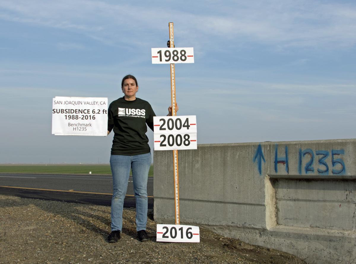
The pace of subsidence slowed until the 1987-93 drought, when increased pumping demands on the aquifers reduced the water table in the Central Valley by as much as 100 feet. Portions of the San Joaquin Valley began to sink again – by 8 feet in some areas. For some water managers, these drought-related events are an indication of long-term problems. In 2009, after years of drought, USGS published a study noting once again drought conditions had caused groundwater pumping to increase, and groundwater levels were approaching their historic lows, leading to more concerns about subsidence.

A 2017 subsidence report by the Jet Propulsion Laboratory identified two known main subsidence bowls in the San Joaquin Valley: the larger centered on Corcoran and extending 60 miles to the northwest, affecting the California Aqueduct. Between May 2015 and September 2016 maximum total subsidence was found to be about 22 inches near Corcoran. A second bowl is centered on El Nido and is approximately 25 miles in diameter, encompassing most of the East Side Bypass. 

Subsidence impacts the Friant-Kern Canal, which is sinking so much that it has lost about 60 percent of its flow. The 152-mile canal from Millerton Lake to Kern County was built in the 1940s. It has sunk two to three feet in some places over about a 25 mile area. The original design capacity 4,000 cubic feet per second in that area has dropped to 1,600 cfs. 

  • Print-friendly

Referring Pages

Western Water November 16, 2017 Layperson's Guide to the State Water Project Land Subsidence Gary Pitzer

State Taking Steps to Manage Subsidence-Related Impacts to California Aqueduct
Department of Water Resources to spend $5 million for quick fixes, as it assesses longer-term repairs

For as long as agriculture has existed in the Central Valley, farmers have pumped water from the ground to sustain their livelihood and grow food consumed by much of the nation. This has caused the ground in certain places to sink, sometimes dramatically, eliminating valuable aquifer storage space that can never be restored.

  • Read more
  • Layperson's Guide to the State Water Project

Share this page

  • Share on Facebook
  • Share on Twitter
  • Share on LinkedIn
  • Sent to a friend.
Print-friendly

Related Links

Aquapedia background February 11, 2014
Back
This item appears in:
  • L
Footer pod May 20, 2014

Water Education Foundation

Copyright © 2023 Water Education Foundation. All rights reserved.

The Water Education Foundation is a nonprofit, tax-exempt, 501(c)3 organization, federal tax ID #942419885.

Privacy Policy

Donor Privacy Policy

  • Read more
Footer pod May 20, 2014

Contact Information

2151 River Plaza Drive, Suite 205
Sacramento CA 95833

Telephone (916) 444-6240

Contact Us via email

  • Read more

Quicklinks

Footer quicklink May 20, 2014

Contact Us

  • Read more
Footer quicklink May 20, 2014

Donate Today

  • Read more
Footer quicklink May 20, 2014

Tours

  • Read more
Footer quicklink May 20, 2014

Newsletter Signup

  • Read more
Footer quicklink May 20, 2014

Foundation News

  • Read more
Footer quicklink May 20, 2014

Calendar

  • Read more

Log in

  • Create new account
  • Request new password

Commands

  • Support portal
  • Log in