Header link June 22, 2020

LinkedIn

  • Read more
Header link September 15, 2014

Cart

  • Read more
Header link November 3, 2015

Donate Now

  • Read more
Header link May 15, 2014

Twitter

  • Read more
Header link May 15, 2014

Facebook

  • Read more
Instagram
Header link May 15, 2014

Instagram

  • Read more
Header link May 15, 2014

Contact Us

  • Read more
More options
Water Education Foundation
Home

Water Education Foundation

Everything about California water that matters
  • Water Academy
    • Agriculture
      • Agricultural Conservation
      • Agricultural Drainage
    • Background Information
      • Legislation — California and Federal
      • Regulations — California and Federal
      • Water History
      • Water Rights
    • Bay-Delta
      • Bay Delta
      • Bay Delta Conservation Plan
      • Delta Issues
      • Delta Smelt
      • Sacramento San Joaquin Delta
      • San Francisco Bay
      • Suisun Marsh
    • Dams, Reservoirs and Water Projects
      • California Aqueduct
      • Central Valley Project
      • Folsom Dam
      • Friant Dam
      • Hetch Hetchy
      • Hoover Dam
      • Infrastructure
      • Lake Mead
      • Lake Powell
      • Oroville Dam
      • San Luis Dam
      • Shasta Dam
      • State Water Project
    • Environmental Issues
      • Anadromous Fish Restoration
      • Ecosystem
      • Endangered Species Act
      • Invasive species
      • Lake Tahoe
      • Mono Lake
      • Public Trust Doctrine
      • Salmon
      • San Joaquin River Restoration
      • Watershed
      • Wetlands
    • Leaders and Experts
    • Regions
      • Central Coast
      • Central Valley
      • Mexico
      • Nevada
      • North Coast
      • Pyramid Lake
      • Sacramento Valley
      • Salton Sea
      • San Joaquin Valley
      • Sierra Nevada
      • Southern California
      • Tulare Lake Basin
    • Rivers
      • Carson River
      • Colorado River
      • Klamath River
      • New River
      • North Coast Rivers
      • Russian River
      • Sacramento River
      • Truckee River
      • San Joaquin River
    • Water Issues
      • Climate Change
      • Coronavirus
      • Drought
      • Earthquakes
      • Energy and Water
      • Floods
      • Fracking
      • Growth
      • Hydropower
      • Levees
      • Tribal Water Issues
      • Water Conservation
      • Water Equity
    • Water Quality
      • Drinking Water
      • Nitrate contamination
      • Pollution
      • Stormwater
      • Wastewater
      • Water Quality
    • Water Supply and Management
      • Acre Foot
      • Aquifers
      • California Water Plan
      • Conjunctive Use
      • Desalination
      • Grey water
      • Groundwater
      • Integrated Regional Water Management
      • Recreation
      • Surface Water
      • Water Marketing and Banking
      • Water Rates
      • Water Recycling
      • Water Supply
      • Water Transfers
  • Tours & Events
    • Water Tours
      • 2023 Tour Sponsors
    • Events
    • Event Calendar
    • Past Tours & Events
      • Anne J. Schneider Fund Lecture Series
  • Specialized Programs
    • Water Leaders
      • Class Rosters
      • Yearly Class Reports
      • Your Alumni Network
      • Alumni Profiles
    • Project WET
      • Workshops
      • Special Workshops & Events
      • Supplementary Materials
      • California Content Standard Correlations
      • Facilitator's Trainings
      • Foundation School Programs
        • Elementary Programs
        • Secondary Programs
      • Water Kids
      • California Project WET Gazette
      • Gazette Archives
    • Colorado River Project
    • GRA Scholastic Fund Program
  • Maps & Guides
    • Maps & Posters
    • Layperson's Guides
    • Map & Guide Bundles
    • Books
    • Colorado River Materials
    • California Runoff Rundown
    • Other Publications
    • Water Awareness Materials
    • Downloadable Publications
    • Videos and DVDs
      • Video Clips
    • School Age Publications
    • Stickers
    • Free Programs and Publications
  • Newsroom
    • Western Water News
    • Aquafornia
      • About Aquafornia
    • Information Desk
    • Western Water Magazine Archive
      • Full Print Edition
      • Print Edition Excerpts
    • River Report Archive
  • Aquapedia
    • Alphabetical List of Subjects
      • A
      • B
      • C
      • D
      • E
      • F
      • G
      • H
      • I
      • J
      • K
      • L
      • M
      • N
      • O
      • P
      • Q
      • R
      • S
      • T
      • U
      • V
      • W
      • X
      • Y
      • Z
    • Historical Water People
    • Where Does My Water Come From?
      • Northern California
      • Sacramento
      • North Bay
      • South Bay
      • Central Valley
      • Los Angeles
      • Inland Empire
      • San Diego
      • All California Water Sources
    • Timelines
    • Videos
    • Image Gallery
    • Water Directory
      • Federal Agencies
      • State Agencies in California
      • Environmental Organizations
      • Other California Organizations
      • State and Federal Legislative Committees
      • Water Associations and Groups
      • Western States Water Agencies and Districts
    • Online Resources
    • Useful Acronyms
    • About Aquapedia
  • About
    • About Us
      • Board of Directors
      • Staff Biographies
      • Job Openings
    • Announcements
    • Support Our Mission
      • Become a Member
      • Donate in Honor/Memory
      • Donate to Aquapedia or Aquafornia
      • Shop Amazon
      • Planned Giving
    • Contact Us
Aquapedia background February 11, 2014

San Joaquin Valley

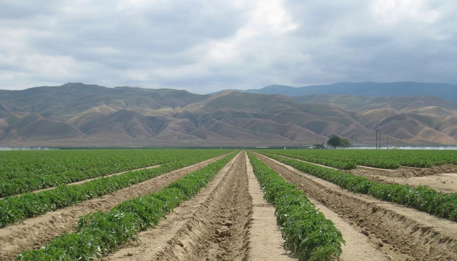
Located in the middle of California, the San Joaquin Valley is bracketed on both sides by mountain ranges. Long and flat, the valley’s hot, dry summers are followed by cool, foggy winters that make it one of the most productive agricultural regions in the world.

The valley stretches from across mid-California between coastal ranges in west and the Sierras on the east. The region includes large cities such as Fresno and Bakersfield, national parks such as Yosemite and Kings, millions of people, and fertile farmland.

As is the case across California and the west, the San Joaquin Valley and its multi-billion dollar agricultural industry relies on water.

Irrigation began in the San Joaquin Valley in the 1870s. In the 20th century, the federal Central Valley Project and State Water Project (about 30 percent of SWP water is used for irrigation) helped deliver water to the valley. As farming continued to expand and California’s population surged, water use intensified.

Today, San Joaquin Valley crops include grapes, tomatoes, hay, sugar beets, nuts, cotton and a multitude of other fruits and vegetables. At the same time, water used to grow these crops has led to the need for agricultural drainage.

Agricultural Drainage and the San Joaquin Valley

On the west side of the San Joaquin Valley, federal and state water projects bring tons of salt to the area (the equivalent of about forty railroad cars daily according to estimates). The dense, clay soil then prevents the salty water from permeating deeply and instead it becomes part of the shallow groundwater table. The salty water collects and rises to the surface, drowning plants.

In areas without such an impermeable layer, the leached water percolates into an unconfined groundwater aquifer.

Already, the San Joaquin Valley is naturally rich in salt and trace minerals such as selenium—a geologic legacy from when the area was long-ago a part of the Pacific Ocean.

What to do, then, with all that salt?

The San Joaquin River helps drain its namesake valley in the north. However, this drainage adds salt to the river as it makes its way to the  Sacramento-San Joaquin Delta and from there to San Francisco Bay. Virtually no salt leaves the southern valley and thousands of acres of land in there are not farmable due to salt buildup.

The largest single district affected by the lack of adequate drainage is the 600,000 acre Westlands Water District, the largest irrigation district in the United States. Located in the Central Valley Project’s San Luis Unit service area on the west side of the valley, Westlands has no drainage access to the San Joaquin River. According to Westlands, approximately 200,000 acres have a shallow saline water table just 5 feet or less below the surface. Another 30,000 acres have saline water 5 to 10 feet below the surface. At depths of less than 10 feet, saline water begins to affect crop productivity.

Overall, the San Joaquin Valley’s poorly drained, naturally saline soils threaten crop productivity.

Compounding these concerns, extensive groundwater extraction has caused San Joaquin land to sink, a process known as land subsidence. Land subsidence has been a particular concern in Merced and Madera counties.

  • Print-friendly

Referring Pages

Share this page

  • Share on Facebook
  • Share on Twitter
  • Share on LinkedIn
  • Sent to a friend.
Print-friendly

Related Links

Aquapedia background February 11, 2014
Back
This item appears in:
  • Topic: San Joaquin Valley
  • S
Footer pod May 20, 2014

Water Education Foundation

Copyright © 2023 Water Education Foundation. All rights reserved.

The Water Education Foundation is a nonprofit, tax-exempt, 501(c)3 organization, federal tax ID #942419885.

Privacy Policy

Donor Privacy Policy

  • Read more
Footer pod May 20, 2014

Contact Information

2151 River Plaza Drive, Suite 205
Sacramento CA 95833

Telephone (916) 444-6240

Contact Us via email

  • Read more

Quicklinks

Footer quicklink May 20, 2014

Contact Us

  • Read more
Footer quicklink May 20, 2014

Donate Today

  • Read more
Footer quicklink May 20, 2014

Tours

  • Read more
Footer quicklink May 20, 2014

Newsletter Signup

  • Read more
Footer quicklink May 20, 2014

Foundation News

  • Read more
Footer quicklink May 20, 2014

Calendar

  • Read more

Log in

  • Create new account
  • Request new password

Commands

  • Support portal
  • Log in