Sacramento-San Joaquin Delta
 The Sacramento-San Joaquin Delta is
the largest freshwater tidal estuary of its kind on the west
coast of the Americas, providing important habitat for birds on
the Pacific Flyway and
for salmon and other fish that live in or pass through the Delta.
It’s also the hub of California’s two largest surface water
delivery projects, the federal Central Valley Project
and the State Water
Project. The Delta provides a portion of the drinking
water for some 30 million Californians and irrigation water
for large portions of the state’s $61 billion agricultural
industry.
The Sacramento-San Joaquin Delta is
the largest freshwater tidal estuary of its kind on the west
coast of the Americas, providing important habitat for birds on
the Pacific Flyway and
for salmon and other fish that live in or pass through the Delta.
It’s also the hub of California’s two largest surface water
delivery projects, the federal Central Valley Project
and the State Water
Project. The Delta provides a portion of the drinking
water for some 30 million Californians and irrigation water
for large portions of the state’s $61 billion agricultural
industry.
For nearly half a century, the Delta has been embroiled in continuing controversy over the struggle to restore the faltering ecosystem while maintaining its role as the hub of the state’s water supply. That challenge continues to this day and will be made more difficult by the growing impacts of climate change.
BACKGROUND
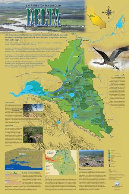
No part of California’s sprawling waterscape is as critical — or controversial — as the Delta. Spanning more than 738,000 acres in six counties, the Delta is fed by the Sacramento and San Joaquin rivers, which gather runoff from across almost 60,000 square miles of mountains, canyons and valleys, or about 40 percent of California’s total land mass. The Delta is often referred to as the “hub” of the state’s water system. The Central Valley Project (CVP) and the State Water Project (SWP) export water from the Delta to more than 30 million people and roughly 2.5 million acres of irrigated farmland in the San Joaquin Valley, San Francisco Bay Area and Southern California.
The Delta itself has a rich cultural heritage that predates the arrival of Europeans in the late 1700s. For more than 10,000 years, the ancestors of the Miwok, Nisenan, Ohlone, Patwin, Pomo, Wappo, Nomlaki, Wintu, Konkow and Yokuts people have called the Delta region home. They sustained themselves by fishing, hunting deer, pronghorn antelope and elk, and gathering native plants and nuts like acorns. The Delta region is still home to the descendants of the Native people who lived there when the Europeans arrived more than two centuries ago.
 Today, nearly three-quarters of a
million people call the Delta home. More than 13,000 people live
in the heart of the Delta, in roughly a dozen “legacy”
communities such as the town of Locke, which was established
during the early 20th century by Chinese immigrants who came to
build the Transcontinental Railroad and later worked constructing
levees in the Delta. Other legacy communities include Walnut
Grove, Freeport, Clarksburg, Hood, Isleton, Rio Vista, Bethel
Island, Courtland and Knightsen. Another roughly 700,000 people
live on the Delta’s more urbanized fringe, in parts of Stockton,
West Sacramento, Tracy, Antioch, Pittsburg and other cities and
towns. Farming is key to the Delta economy and today,
alfalfa, corn, rice, tomatoes, almonds, wine grapes, pears and
other crops are grown on some 480,000 acres.
Today, nearly three-quarters of a
million people call the Delta home. More than 13,000 people live
in the heart of the Delta, in roughly a dozen “legacy”
communities such as the town of Locke, which was established
during the early 20th century by Chinese immigrants who came to
build the Transcontinental Railroad and later worked constructing
levees in the Delta. Other legacy communities include Walnut
Grove, Freeport, Clarksburg, Hood, Isleton, Rio Vista, Bethel
Island, Courtland and Knightsen. Another roughly 700,000 people
live on the Delta’s more urbanized fringe, in parts of Stockton,
West Sacramento, Tracy, Antioch, Pittsburg and other cities and
towns. Farming is key to the Delta economy and today,
alfalfa, corn, rice, tomatoes, almonds, wine grapes, pears and
other crops are grown on some 480,000 acres.
Once an immense wetland, the Delta has been transformed since the California Gold Rush into a complex maze of more than 50 major reclaimed islands intersected by a braided network of some 700 miles of shallow channels and sloughs. Together with San Francisco Bay, the Delta forms the largest freshwater tidal estuary on the west coast of North America.
The Bay-Delta is a highly dynamic mixing zone of salt and fresh water, and its unique environment supports diverse plant, fish and animal life. Suisun Bay and the western Delta mark the brackish transition between fresh water from the rivers and salt water from the ocean. The location of that transition is not fixed because of the constantly shifting interaction between tidal-driven seawater inflows from the Bay and fresh water from the Sierra-fed rivers that flow into the Delta.
In the late 19th and early 20th century, the Delta was home to massive commercial fisheries for both native species like salmon and introduced species like striped bass and American shad. But populations of salmon and several other native fish species have declined because of a combination of export pumping, reduced water flows, poor water quality, limited food supply, lack of habitat and predation by and competition with nonnative species.
 Some 1,100 miles of levees protect farms and communities
there, but they often offer only a tenuous defense. The last
century saw more than 160 levee failures in the Delta. Due to
widespread land subsidence, many of the islands now sit 20 feet
or more below sea level. Continuing subsidence, along with
predictions of climate change-driven sea level rise, has only
increased concern about the strength of these levees. One
particularly serious threat is the risk of multiple, simultaneous
levee breaches, which would pull in salty water from San
Francisco Bay and likely force the shutdown of the export pumps
in the south Delta — cutting off a critical water supply for tens
of millions of people.
Some 1,100 miles of levees protect farms and communities
there, but they often offer only a tenuous defense. The last
century saw more than 160 levee failures in the Delta. Due to
widespread land subsidence, many of the islands now sit 20 feet
or more below sea level. Continuing subsidence, along with
predictions of climate change-driven sea level rise, has only
increased concern about the strength of these levees. One
particularly serious threat is the risk of multiple, simultaneous
levee breaches, which would pull in salty water from San
Francisco Bay and likely force the shutdown of the export pumps
in the south Delta — cutting off a critical water supply for tens
of millions of people.
CONTROVERSIES AND CHALLENGES
One long-running — and continuing — source of controversy has been the establishment and enforcement of a Water Quality Control Plan for the Delta. The effort began in the late 1970s by the State Water Resources Control Board (State Water Board) and was initially focused on ensuring that salinity did not rise to levels that would significantly harm farms and cities dependent on the Delta’s water. Over time, the scope has expanded to include other pollutants and, more significantly, to address the overall health of the Delta ecosystem, largely by maintaining specific levels of flow through the Delta.
The State Water Board has updated the plan several times since 1978. Each update has been highly contentious because of conflicting concerns about water availability for farms and urban areas and adequately protecting the integrity of the Delta ecosystem.
Despite such efforts, the health of the Delta ecosystem has experienced an ongoing decline. In 1989, the Sacramento River winter-run chinook salmon was listed as threatened under the federal Endangered Species Act (ESA). It was followed, in 1993, by the Delta smelt, a small fish seen as a key indicator of ecosystem health. In 1994, the regulatory status of winter-run chinook was changed from threatened to endangered.
 That same year, 1994, state and
federal officials, along with water users and conservation
organizations, agreed to the Bay-Delta Accord, which launched a
cooperative state-federal planning effort called CALFED. The program was ultimately
disbanded, but its focus on rigorous science and an “adaptive
management” approach — which allows water managers to deal with
changing environmental conditions and to capitalize on the
incrementally improving understanding of the Delta’s ecological
dynamics — has shaped subsequent attempts to untangle the Delta’s
many problems.
That same year, 1994, state and
federal officials, along with water users and conservation
organizations, agreed to the Bay-Delta Accord, which launched a
cooperative state-federal planning effort called CALFED. The program was ultimately
disbanded, but its focus on rigorous science and an “adaptive
management” approach — which allows water managers to deal with
changing environmental conditions and to capitalize on the
incrementally improving understanding of the Delta’s ecological
dynamics — has shaped subsequent attempts to untangle the Delta’s
many problems.
During the same period, fish populations in the Delta declined further, and the legal battles over them would soon intensify. In 1998, the Central Valley steelhead was protected as a threatened species under the ESA; it was followed a year later by the Central Valley spring-run chinook. Then, in 2004, scientists identified what they called the “Pelagic Organism Decline,” a broad collapse of not just Delta smelt, but other nonlisted fish like longfin smelt (which would later receive federal protection), threadfin shad and even introduced non-natives like striped bass.
In 2005, the U.S. Fish and Wildlife Service issued a Biological Opinion on the effects of the coordinated operations of the SWP and CVP on Delta smelt, finding that Delta export pumping operations would not jeopardize the continued existence of the fish. Environmental groups challenged the Biological Opinion and set off a seesawing, protracted legal fight. Court-ordered restrictions on Delta export pumping to protect fish limited the amount of water that users — particularly those south of the Delta and in Southern California reliant on CVP or SWP water — could receive.
 California’s landmark 2009 Delta
Reform Act requires the state to manage the Delta in a way that
balances the “co-equal goals” of water supply and ecosystem
protection. The act created an independent state agency called
the Delta
Stewardship Council and charged it with developing a
comprehensive, long-term management plan for the region. The
Delta Plan, adopted in 2013 and later updated, remains the
primary framework for guiding the Delta into the future.
California’s landmark 2009 Delta
Reform Act requires the state to manage the Delta in a way that
balances the “co-equal goals” of water supply and ecosystem
protection. The act created an independent state agency called
the Delta
Stewardship Council and charged it with developing a
comprehensive, long-term management plan for the region. The
Delta Plan, adopted in 2013 and later updated, remains the
primary framework for guiding the Delta into the future.
In order to “isolate” a portion of the agricultural and urban water supply from the ecosystem to reduce conflicts between the two, the concept of a canal or tunnel around the Delta was first proposed in the 1950s as part of what became the SWP. But the idea has been a political lightning rod.
In 1982, California voters rejected a statewide referendum that would have authorized construction of a canal and other facilities to divert water around the Delta into the State Water Project’s system of pumps and canals. In the years since, the concept has been revived in various forms.
The current incarnation, a one-tunnel concept called the Delta Conveyance Project, has been slowly working its way through the approval process but has faced considerable opposition. The concept of an isolated conveyance facility is opposed by many in-Delta residents and conservation groups who believe it would lead to greater water exports while depriving Delta farmers and the environment of much-needed freshwater inflow to counteract the incoming salty ocean water.
The Bay-Delta Water Quality Control Plan also continues to be a much-debated issue. In 2018, the State Water Board adopted — but has yet to implement — an updated plan that would require as much as half of the flow to remain in the San Joaquin River system between February and June each year to aid Delta fisheries and combat salinity levels. That would significantly reduce the amount of water available for farms and cities.
Concerned that the requirement would be too stringent, water users began an effort to negotiate a set of “voluntary agreements” with state agencies that focus not just on flow but also on habitat and fish passage improvements to benefit the ecosystem. The voluntary agreements — now known as the Healthy Rivers and Landscapes Program — would provide an alternative pathway to meeting the environmental goals of the “unimpaired flow” requirement in the updated Water Quality Control Plan.
A similar update is underway for the Sacramento River watershed and the Delta itself. In 2025, the State Water Board released a draft plan that incorporates the voluntary agreements as an alternative compliance pathway to an unimpaired flow requirement there. Numerous environmental and fishing groups and tribes, concerned that they were not included in the negotiation of the voluntary agreements, have voiced strong opposition to the provisions of the new Water Quality Control Plan — meaning that the effort, like so many others before it, could wind up entangled in the courts.
LOOKING AHEAD

Climate change will bring big changes to the Delta. Melting polar ice caps will raise the sea level worldwide and bring more saltwater into the Delta, as well as place additional strain on levees. In the Sierra Nevada mountains — the source of the majority of the water that flows through the Delta — average annual total precipitation amounts are not expected to change significantly. But rising air temperatures will likely cause a higher portion of precipitation to fall as rain rather than snow, thereby decreasing the annual snowpack and increasing the frequency and intensity of high runoff events into the Delta.
In 2025, the Delta Stewardship Council released the first-ever climate adaptation plan for the Delta, a broad road map to help the region keep pace with the changing climate. The plan noted that by 2050, climate change impacts will likely reduce Delta water exports by 10 percent to 20 percent per year.
Updated: January 2026