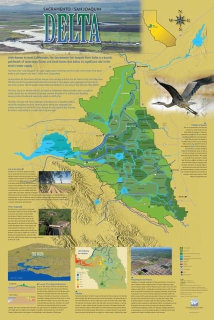
Header link June 22, 2020

LinkedIn

  • Read more
Header link September 15, 2014

Cart

  • Read more
Header link November 3, 2015

Donate Now

  • Read more
Header link May 15, 2014

Twitter

  • Read more
Header link May 15, 2014

Facebook

  • Read more
Instagram
Header link May 15, 2014

Instagram

  • Read more
Header link May 15, 2014

Contact Us

  • Read more
More options
Water Education Foundation
Home

Water Education Foundation

Everything about California water that matters
  • Water Academy
    • Agriculture
      • Agricultural Conservation
      • Agricultural Drainage
    • Background Information
      • Legislation — California and Federal
      • Regulations — California and Federal
      • Water History
      • Water Rights
    • Bay-Delta
      • Bay Delta
      • Bay Delta Conservation Plan
      • Delta Issues
      • Delta Smelt
      • Sacramento San Joaquin Delta
      • San Francisco Bay
      • Suisun Marsh
    • Dams, Reservoirs and Water Projects
      • California Aqueduct
      • Central Valley Project
      • Folsom Dam
      • Friant Dam
      • Hetch Hetchy
      • Hoover Dam
      • Infrastructure
      • Lake Mead
      • Lake Powell
      • Oroville Dam
      • San Luis Dam
      • Shasta Dam
      • State Water Project
    • Environmental Issues
      • Anadromous Fish Restoration
      • Ecosystem
      • Endangered Species Act
      • Invasive species
      • Lake Tahoe
      • Mono Lake
      • Public Trust Doctrine
      • Salmon
      • San Joaquin River Restoration
      • Watershed
      • Wetlands
    • Leaders and Experts
    • Regions
      • Central Coast
      • Central Valley
      • Mexico
      • Nevada
      • North Coast
      • Pyramid Lake
      • Sacramento Valley
      • Salton Sea
      • San Joaquin Valley
      • Sierra Nevada
      • Southern California
      • Tulare Lake Basin
    • Rivers
      • Carson River
      • Colorado River
      • Klamath River
      • New River
      • North Coast Rivers
      • Russian River
      • Sacramento River
      • Truckee River
      • San Joaquin River
    • Water Issues
      • Climate Change
      • Coronavirus
      • Drought
      • Earthquakes
      • Energy and Water
      • Flood Management
      • Fracking
      • Growth
      • Hydropower
      • Levees
      • Tribal Water Issues
      • Water Conservation
      • Water Equity
    • Water Quality
      • Drinking Water
      • Nitrate contamination
      • Pollution
      • Stormwater
      • Wastewater
      • Water Quality
    • Water Supply and Management
      • Acre Foot
      • Aquifers
      • California Water Plan
      • Conjunctive Use
      • Desalination
      • Grey water
      • Groundwater
      • Integrated Regional Water Management
      • Recreation
      • Surface Water
      • Water Marketing and Banking
      • Water Rates
      • Water Recycling
      • Water Supply
      • Water Transfers
  • Tours & Events
    • Water Tours
      • 2023 Tour Sponsors
    • Events
    • Event Calendar
    • Past Tours & Events
      • Anne J. Schneider Fund Lecture Series
  • Specialized Programs
    • Water Leaders
      • Class Rosters
      • Yearly Class Reports
      • Your Alumni Network
      • Alumni Profiles
    • Project WET
      • Workshops
      • Special Workshops & Events
      • Supplementary Materials
      • California Content Standard Correlations
      • Facilitator's Trainings
      • Foundation School Programs
        • Elementary Programs
        • Secondary Programs
      • Water Kids
      • California Project WET Gazette
      • Gazette Archives
    • Colorado River Project
    • GRA Scholastic Fund Program
  • Maps & Guides
    • Maps & Posters
    • Layperson's Guides
    • Map & Guide Bundles
    • Books
    • Colorado River Materials
    • California Runoff Rundown
    • Other Publications
    • Water Awareness Materials
    • Downloadable Publications
    • Videos and DVDs
      • Video Clips
    • School Age Publications
    • Stickers
    • Free Programs and Publications
  • Newsroom
    • Western Water News
    • Aquafornia
      • About Aquafornia
    • Information Desk
    • Western Water Magazine Archive
      • Full Print Edition
      • Print Edition Excerpts
    • River Report Archive
  • Aquapedia
    • Alphabetical List of Subjects
      • A
      • B
      • C
      • D
      • E
      • F
      • G
      • H
      • I
      • J
      • K
      • L
      • M
      • N
      • O
      • P
      • Q
      • R
      • S
      • T
      • U
      • V
      • W
      • X
      • Y
      • Z
    • Historical Water People
    • Where Does My Water Come From?
      • Northern California
      • Sacramento
      • North Bay
      • South Bay
      • Central Valley
      • Los Angeles
      • Inland Empire
      • San Diego
      • All California Water Sources
    • Timelines
    • Videos
    • Image Gallery
    • Water Directory
      • Federal Agencies
      • State Agencies in California
      • Environmental Organizations
      • Other California Organizations
      • State and Federal Legislative Committees
      • Water Associations and Groups
      • Western States Water Agencies and Districts
    • Online Resources
    • Useful Acronyms
    • About Aquapedia
  • About
    • About Us
      • Board of Directors
      • Staff Biographies
      • Job Openings
    • Announcements
    • Support Our Mission
      • Become a Member
      • Donate in Honor/Memory
      • Donate to Aquapedia or Aquafornia
      • Shop Amazon
      • Planned Giving
    • Contact Us
Aquapedia background February 11, 2014 Sacramento-San Joaquin Delta Map Layperson's Guide to the Delta

Suisun Marsh

The Suisun Marsh is the largest contiguous brackish water wetland in western North America, providing food and habitat for thousands of migratory birds and many species of plants, fish and wildlife. The combination of tidal wetlands, diked seasonal wetlands, sloughs and upland grassland comprises more than 10 percent of the remaining wetlands in California.

The marsh is where fresh water from the Sacramento-San Joaquin Delta meets salt water from San Francisco Bay.

Fed by runoff from the northern Sierra Nevada mountains and the southern Cascades, the Sacramento River flows south to meet the northbound San Joaquin River just south of the city of Sacramento where the Sacramento-San Joaquin Delta is formed.

Here, settlers transformed the marsh into agricultural and ranching land and later the area became a popular spot for hunting birds (Suisun Marsh is a critical part of the Pacific Flyway for migratory birds).

The rivers’ combined fresh water flows roll through the Carquinez Strait, a narrow break in the Coast Range, and into San Francisco Bay’s northern arm, forming the San Francisco Bay/Sacramento-San Joaquin Delta Estuary, commonly referred to as the Bay Delta.

Suisun Marsh and adjoining bays are the brackish transition between fresh and salt water. But the location of that transition is not fixed. Hydrologic studies suggest the Delta works like a giant washing machine agitator, with tidal forces and river flows constantly sloshing water back and forth.

Suisun Marsh Challenges

There are approximately 230 miles of levees protecting over 50,000 acres of marsh land in the Suisun Marsh. Only about a third of the Delta levees (385 miles) are part of a federal flood management project of the Sacramento and San Joaquin River systems and, as a result, are eligible for rehabilitation by the Corps. All of the Suisun Marsh levees – are local levees constructed and maintained during the past 130 years by local reclamation districts.

Delta salinity impacts the Suisun environment as well. Plant growth, for instance, can be affected, which in turn can affect waterfowl that feed on the plants. The State Water Project’s Suisun Marsh Salinity Control Gates near Collinsville modify tidal flows through Montezuma Slough, limiting upstream movement of salty tidal flows into Suisun Marsh.

California’s Department of Water Resources built the salinity control gates in the 1980s. According to DWR, the gates “control salinity by restricting the flow of higher salinity water from Grizzly Bay into Montezuma Slough during incoming tides and retaining lower salinity Sacramento River water from the previous ebb tide.”

This usually takes place from October to May and helps moderate salinity in marsh channels.

Pelagic fish declines and scientific surveys of the Delta and Suisun Marsh in 2005 revealed ongoing, sweeping population crash of native pelagic fish. The decline could not be explained by drought or any other easily identifiable cause.

The Bay Delta Conservation Plan is responsible for developing an in-Delta and Suisun Marsh habitat restoration program. The BDCP conservation efforts are in accordance with the federal and state Endangered Species Act and the state’s Natural Community Conservation Planning Act.

  • Print-friendly

Referring Pages

Share this page

  • Share on Facebook
  • Share on Twitter
  • Share on LinkedIn
  • Sent to a friend.
Print-friendly

Related Links

Aquapedia background February 11, 2014 Sacramento-San Joaquin Delta Map Layperson's Guide to the Delta
Delta Map for the Sacramento-San Joaquin Delta
Maps & Posters March 5, 2021 Layperson's Guide to the Delta Sacramento-San Joaquin Delta Education Bundle

Sacramento-San Joaquin Delta Map
Published March 2021

This beautifully illustrated 24×36-inch poster, suitable for framing and display in any office or classroom, highlights the Sacramento-San Joaquin River Delta, its place as a center of farming, its importance as an ecological resource and its vital role in California’s water supply system. 

The text, photos and graphics explain issues related to land subsidence, levees and flooding, urbanization, farming, fish and wildlife protection. An inset map illustrates the tidal action that increases the salinity of the Delta’s waterways. 

  • Read more
Publication April 17, 2014

Layperson’s Guide to the Delta
Updated 2020

The 24-page Layperson’s Guide to the Delta explores the competing uses and demands on California’s Sacramento-San Joaquin Delta. Included in the guide are sections on the history of the Delta, its role in the state’s water system, and its many complex issues with sections on water quality, levees, salinity and agricultural drainage, fish and wildlife, and water distribution.

  • Read more
Back
This item appears in:
  • Topic: Suisun Marsh
  • S
Footer pod May 20, 2014

Water Education Foundation

Copyright © 2023 Water Education Foundation. All rights reserved.

The Water Education Foundation is a nonprofit, tax-exempt, 501(c)3 organization, federal tax ID #942419885.

Privacy Policy

Donor Privacy Policy

  • Read more
Footer pod May 20, 2014

Contact Information

2151 River Plaza Drive, Suite 205
Sacramento CA 95833

Telephone (916) 444-6240

Contact Us via email

  • Read more

Quicklinks

Footer quicklink May 20, 2014

Contact Us

  • Read more
Footer quicklink May 20, 2014

Donate Today

  • Read more
Footer quicklink May 20, 2014

Tours

  • Read more
Footer quicklink May 20, 2014

Newsletter Signup

  • Read more
Footer quicklink May 20, 2014

Foundation News

  • Read more
Footer quicklink May 20, 2014

Calendar

  • Read more

Log in

  • Create new account
  • Request new password

Commands

  • Support portal
  • Log in