Header link June 22, 2020

LinkedIn

  • Read more
Header link September 15, 2014

Cart

  • Read more
Header link November 3, 2015

Donate Now

  • Read more
Header link May 15, 2014

Twitter

  • Read more
Header link May 15, 2014

Facebook

  • Read more
Instagram
Header link May 15, 2014

Instagram

  • Read more
Header link May 15, 2014

Contact Us

  • Read more
More options
Water Education Foundation
Home

Water Education Foundation

Everything about California water that matters
  • Water Academy
    • Agriculture
      • Agricultural Conservation
      • Agricultural Drainage
    • Background Information
      • Legislation — California and Federal
      • Regulations — California and Federal
      • Water History
      • Water Rights
    • Bay-Delta
      • Bay Delta
      • Bay Delta Conservation Plan
      • Delta Issues
      • Delta Smelt
      • Sacramento San Joaquin Delta
      • San Francisco Bay
      • Suisun Marsh
    • Dams, Reservoirs and Water Projects
      • California Aqueduct
      • Central Valley Project
      • Folsom Dam
      • Friant Dam
      • Hetch Hetchy
      • Hoover Dam
      • Infrastructure
      • Lake Mead
      • Lake Powell
      • Oroville Dam
      • San Luis Dam
      • Shasta Dam
      • State Water Project
    • Environmental Issues
      • Anadromous Fish Restoration
      • Ecosystem
      • Endangered Species Act
      • Invasive species
      • Lake Tahoe
      • Mono Lake
      • Public Trust Doctrine
      • Salmon
      • San Joaquin River Restoration
      • Watershed
      • Wetlands
    • Leaders and Experts
    • Regions
      • Central Coast
      • Central Valley
      • Mexico
      • Nevada
      • North Coast
      • Pyramid Lake
      • Sacramento Valley
      • Salton Sea
      • San Joaquin Valley
      • Sierra Nevada
      • Southern California
      • Tulare Lake Basin
    • Rivers
      • Carson River
      • Colorado River
      • Klamath River
      • New River
      • North Coast Rivers
      • Russian River
      • Sacramento River
      • Truckee River
      • San Joaquin River
    • Water Issues
      • Climate Change
      • Coronavirus
      • Drought
      • Earthquakes
      • Energy and Water
      • Flood Management
      • Fracking
      • Growth
      • Hydropower
      • Levees
      • Tribal Water Issues
      • Water Conservation
      • Water Equity
    • Water Quality
      • Drinking Water
      • Nitrate contamination
      • Pollution
      • Stormwater
      • Wastewater
      • Water Quality
    • Water Supply and Management
      • Acre Foot
      • Aquifers
      • California Water Plan
      • Conjunctive Use
      • Desalination
      • Grey water
      • Groundwater
      • Integrated Regional Water Management
      • Recreation
      • Surface Water
      • Water Marketing and Banking
      • Water Rates
      • Water Recycling
      • Water Supply
      • Water Transfers
  • Tours & Events
    • Water Tours
      • 2023 Tour Sponsors
    • Events
    • Event Calendar
    • Past Tours & Events
      • Anne J. Schneider Fund Lecture Series
  • Specialized Programs
    • Water Leaders
      • Class Rosters
      • Yearly Class Reports
      • Your Alumni Network
      • Alumni Profiles
    • Project WET
      • Workshops
      • Special Workshops & Events
      • Supplementary Materials
      • California Content Standard Correlations
      • Facilitator's Trainings
      • Foundation School Programs
        • Elementary Programs
        • Secondary Programs
      • Water Kids
      • California Project WET Gazette
      • Gazette Archives
    • Colorado River Project
    • GRA Scholastic Fund Program
  • Maps & Guides
    • Maps & Posters
    • Layperson's Guides
    • Map & Guide Bundles
    • Books
    • Colorado River Materials
    • California Runoff Rundown
    • Other Publications
    • Water Awareness Materials
    • Downloadable Publications
    • Videos and DVDs
      • Video Clips
    • School Age Publications
    • Stickers
    • Free Programs and Publications
  • Newsroom
    • Western Water News
    • Aquafornia
      • About Aquafornia
    • Information Desk
    • Western Water Magazine Archive
      • Full Print Edition
      • Print Edition Excerpts
    • River Report Archive
  • Aquapedia
    • Alphabetical List of Subjects
      • A
      • B
      • C
      • D
      • E
      • F
      • G
      • H
      • I
      • J
      • K
      • L
      • M
      • N
      • O
      • P
      • Q
      • R
      • S
      • T
      • U
      • V
      • W
      • X
      • Y
      • Z
    • Historical Water People
    • Where Does My Water Come From?
      • Northern California
      • Sacramento
      • North Bay
      • South Bay
      • Central Valley
      • Los Angeles
      • Inland Empire
      • San Diego
      • All California Water Sources
    • Timelines
    • Videos
    • Image Gallery
    • Water Directory
      • Federal Agencies
      • State Agencies in California
      • Environmental Organizations
      • Other California Organizations
      • State and Federal Legislative Committees
      • Water Associations and Groups
      • Western States Water Agencies and Districts
    • Online Resources
    • Useful Acronyms
    • About Aquapedia
  • About
    • About Us
      • Board of Directors
      • Staff Biographies
      • Job Openings
    • Announcements
    • Support Our Mission
      • Become a Member
      • Donate in Honor/Memory
      • Donate to Aquapedia or Aquafornia
      • Shop Amazon
      • Planned Giving
    • Contact Us
Publication April 17, 2014 Sacramento-San Joaquin Delta Map

Layperson’s Guide to the Delta
Updated 2020

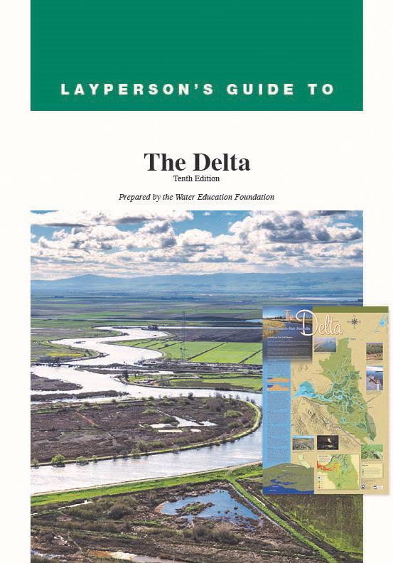
The 24-page Layperson’s Guide to the Delta explores the competing uses and demands on California’s Sacramento-San Joaquin Delta. Included in the guide are sections on the history of the Delta, its role in the state’s water system, and its many complex issues with sections on water quality, levees, salinity and agricultural drainage, fish and wildlife, and water distribution.

The 2020 version includes the latest information about California EcoRestore, the Bay-Delta Water Quality Control Plan, Delta conveyance, new information about ongoing Delta litigation, invasive species, a glossary of common terms and information on the many state and federal agencies involved in Delta issues.

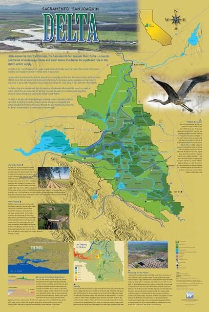
Complementing the guide is the Sacramento-San Joaquin Delta Map.

Order in bulk (25 or more copies of the same guide) for a reduced fee. Contact the Foundation, 916-444-6240, for details.

  • Print-friendly

Referring Pages

Western Water February 25, 2022 Alastair Bland Sacramento-San Joaquin Delta Map Layperson's Guide to the Delta WESTERN WATER-With Delta Smelt Virtually Gone in the Wild, A "Hatch-and-Release" Program Aims to Save Them From Extinction By Alastair Bland

With Delta Smelt All But Gone in the Wild, A First-Ever “Hatch-and-Release” Effort Aims to Save Them From Extinction
WESTERN WATER NOTEBOOK: Experimental releases of finger-size fish into Sacramento-San Joaquin Delta inspires hope, but also skepticism, about the smelt's future

Crew releases hatchery-raised Delta smelt into the Sacramento-San Joaquin Delta. In the vast labyrinth of the West Coast’s largest freshwater tidal estuary, one native fish species has never been so rare. Once uncountably numerous, the Delta smelt was placed on state and federal endangered species lists in 1993, stopped appearing in most annual sampling surveys in 2016, and is now, for all practical purposes, extinct in the wild. At least, it was.

  • Read more
Announcement August 26, 2021 Layperson's Guide to the Delta

Explore California’s Vital Water Hub During Sept. 9 Virtual Journey
Join us online for diverse views & conversations on hot topics during our Bay-Delta Tour

The Sacramento-San Joaquin Delta, the largest estuary on the West Coast, is a vital hub in California’s complex water delivery system as well as a rich farming region, an important wetlands area – and often, a source of conflict.

Join us for an engaging online journey on Sept. 9 to go deep into the Delta and its 720,000-acre network of islands and canals that supports the state’s two large water systems - the State Water Project and the federal Central Valley Project.

  • Read more
Tour September 9, 2021 - 2:30pm - 5:30pm Nick Gray Jenn Bowles Layperson's Guide to the Delta

Bay-Delta Tour 2021
A Virtual Journey - September 9

This tour guided participants on a virtual journey deep into California’s most crucial water and ecological resource – the Sacramento-San Joaquin Delta. The 720,000-acre network of islands and canals support the state’s two major water systems – the State Water Project and the Central Valley Project. The Delta and the connecting San Francisco Bay form the largest freshwater tidal estuary of its kind on the West coast.

  • Read more
Maps & Posters March 5, 2021 Layperson's Guide to the Delta Sacramento-San Joaquin Delta Education Bundle

Sacramento-San Joaquin Delta Map
Published March 2021

Delta Map for the Sacramento-San Joaquin Delta

This beautifully illustrated 24×36-inch poster, suitable for framing and display in any office or classroom, highlights the Sacramento-San Joaquin River Delta, its place as a center of farming, its importance as an ecological resource and its vital role in California’s water supply system. 

The text, photos and graphics explain issues related to land subsidence, levees and flooding, urbanization, farming, fish and wildlife protection. An inset map illustrates the tidal action that increases the salinity of the Delta’s waterways. 

  • Read more
Western Water February 26, 2021 Layperson's Guide to the Delta New Lead Scientist Primed for Sacramento-San Joaquin Delta’s Challenges After a Lifetime Surrounded by Water By Gary Pitzer

New Lead Scientist Primed for Sacramento-San Joaquin Delta’s Challenges After a Lifetime Surrounded by Water
WESTERN WATER Q&A: Laurel Larsen stresses greater communication and inclusivity in a more nimble Delta science program

Delta Lead Scientist Laurel Larsen has spent her career studying the intricacies of wetlands environments, such as this marsh in southern Louisiana. In the Sacramento-San Joaquin Delta, Larsen will face a challenging environment that has confounded water management for decades. It’s perhaps no surprise new Delta Lead Scientist Laurel Larsen finds herself in the thick of untangling the many mysteries surrounding the Sacramento-San Joaquin Delta ecosystem.

After all, Larsen grew up in Florida, where deep, marshy backwaters of the Everglades are reminiscent of the large tidal estuary that is California’s most crucial water and ecological resource. Larsen’s background stirred her interest early.

  • Read more
Western Water October 23, 2020 Layperson's Guide to the Delta By Gary Pitzer

Is Ecosystem Change in the Sacramento-San Joaquin Delta Outpacing the Ability of Science to Keep Up?
WESTERN WATER IN-DEPTH: Science panel argues for a new approach to make research nimbler and more forward-looking to improve management in the ailing Delta

Floating vegetation such as water hyacinth has expanded in the Delta in recent years, choking waterways like the one in the bottom of this photo.Radically transformed from its ancient origin as a vast tidal-influenced freshwater marsh, the Sacramento-San Joaquin Delta ecosystem is in constant flux, influenced by factors within the estuary itself and the massive watersheds that drain though it into the Pacific Ocean.

Lately, however, scientists say the rate of change has kicked into overdrive, fueled in part by climate change, and is limiting the ability of science and Delta water managers to keep up. The rapid pace of upheaval demands a new way of conducting science and managing water in the troubled estuary.

  • Read more
Western Water March 23, 2018 Layperson's Guide to the Delta

ON THE ROAD: Park Near Historic Levee Rupture Offers Glimpse of Old Sacramento-San Joaquin Delta
Big Break Regional Shoreline will be a stop on Bay-Delta Tour May 16-18

Visitors explore a large, three-dimensional map of the Sacramento-San Joaquin Delta at Big Break Regional Shoreline in Oakley. Along the banks of the Sacramento-San Joaquin Delta in Oakley, about 50 miles southwest of Sacramento, is a park that harkens back to the days when the Delta lured Native Americans, Spanish explorers, French fur trappers, and later farmers to its abundant wildlife and rich soil.

That historical Delta was an enormous marsh linked to the two freshwater rivers entering from the north and south, and tidal flows coming from the San Francisco Bay. After the Gold Rush, settlers began building levees and farms, changing the landscape and altering the habitat.

  • Read more
Aquapedia background August 7, 2017 Layperson's Guide to the Delta

Estuary

Suisun Marsh, part of the San Francisco Bay-Delta estuary, is the largest contiguous brackish water marsh on the West Coast of North America.Estuaries are places where fresh and salt water mix, usually at the point where a river enters the ocean. They are the meeting point between riverine environments and the sea, with a combination of tides, waves, salinity, fresh water flow and sediment. The constant churning means there are elevated levels of nutrients, making estuaries highly productive natural habitats.

  • Read more
Aquapedia background February 11, 2014 Sacramento-San Joaquin Delta Map Layperson's Guide to the Delta

Suisun Marsh

The Suisun Marsh is the largest contiguous brackish water wetland in western North America, providing food and habitat for thousands of migratory birds and many species of plants, fish and wildlife. The combination of tidal wetlands, diked seasonal wetlands, sloughs and upland grassland comprises more than 10 percent of the remaining wetlands in California.

The marsh is where fresh water from the Sacramento-San Joaquin Delta meets salt water from San Francisco Bay.

  • Read more
Aquapedia background February 11, 2014 Layperson's Guide to the Delta Sacramento-San Joaquin Delta Map

Sacramento-San Joaquin Delta

The Sacramento-San Joaquin Delta is California’s most crucial water and ecological resource. It is the largest freshwater tidal estuary of its kind on the west coast of the Americas, providing important habitat for birds on the Pacific Flyway and for fish that live in or pass through the Delta. It also the hub of California’s two largest surface water delivery projects, the State Water Project and the federal Central Valley Project. The Delta provides a portion of the drinking water for 27 million Californians and irrigation water for large portions of the state’s $50 billion agricultural industry.

  • Read more
Aquapedia background February 10, 2014 Sacramento-San Joaquin Delta Map Layperson's Guide to the Delta

Invasive Species

Invasive water hyacinth surrounds docks and boats in the Sacramento-San Joaquin Delta. Invasive species, also known as exotics, are plants, animals, insects and aquatic species introduced into non-native habitats.

Often, invasive species travel to non-native areas by ship, either in ballast water released into harbors or attached to the sides of boats. From there, introduced species can then spread and significantly alter ecosystems and the natural food chain as they go. Another example of non-native species introduction is the dumping of aquarium fish into waterways.

  • Read more
Aquapedia background February 3, 2014 Sacramento-San Joaquin Delta Map Layperson's Guide to the Delta

Delta Smelt

The endangered Delta smelt is a 3-inch fish found only in the Sacramento-San Joaquin Delta. It is considered especially sensitive because it lives just one year, has a limited diet and exists primarily in brackish waters (a mix of river-fed fresh and salty ocean water that is typically found in coastal estuaries).

  • Read more

Share this page

  • Share on Facebook
  • Share on Twitter
  • Share on LinkedIn
  • Sent to a friend.
Print-friendly

Related Links

Publication April 17, 2014 Sacramento-San Joaquin Delta Map
Delta Map for the Sacramento-San Joaquin Delta
Maps & Posters March 5, 2021 Layperson's Guide to the Delta Sacramento-San Joaquin Delta Education Bundle

Sacramento-San Joaquin Delta Map
Published March 2021

This beautifully illustrated 24×36-inch poster, suitable for framing and display in any office or classroom, highlights the Sacramento-San Joaquin River Delta, its place as a center of farming, its importance as an ecological resource and its vital role in California’s water supply system. 

The text, photos and graphics explain issues related to land subsidence, levees and flooding, urbanization, farming, fish and wildlife protection. An inset map illustrates the tidal action that increases the salinity of the Delta’s waterways. 

  • Read more
Back
This item appears in:
  • Topic: Acre Foot
  • Topic: Anadromous Fish Restoration
  • Topic: Bay Delta
  • Topic: California Aqueduct
  • Topic: Climate Change
  • Topic: Drinking Water
  • Topic: Legislation — California and Federal
  • Layperson's Guides
  • Topic: Central Valley
  • Topic: Central Valley Project
  • Topic: Ecosystem
  • Topic: Regulations — California and Federal
  • Topic: Drought
  • Topic: Endangered Species Act
  • Topic: Delta Smelt
  • Topic: Earthquakes
  • Topic: Invasive species
  • Topic: Water Rights
  • Topic: Sacramento San Joaquin Delta
  • Topic: Flood Management
  • Topic: San Francisco Bay
  • Topic: Wastewater
  • Topic: Sacramento River
  • Topic: Suisun Marsh
  • Topic: Salmon
  • Topic: San Joaquin River
  • Topic: Levees
  • Topic: Surface Water
  • Topic: Wetlands
  • Topic: Shasta Dam
  • Topic: State Water Project
  • Topic: Water Supply
Footer pod May 20, 2014

Water Education Foundation

Copyright © 2023 Water Education Foundation. All rights reserved.

The Water Education Foundation is a nonprofit, tax-exempt, 501(c)3 organization, federal tax ID #942419885.

Privacy Policy

Donor Privacy Policy

  • Read more
Footer pod May 20, 2014

Contact Information

2151 River Plaza Drive, Suite 205
Sacramento CA 95833

Telephone (916) 444-6240

Contact Us via email

  • Read more

Quicklinks

Footer quicklink May 20, 2014

Contact Us

  • Read more
Footer quicklink May 20, 2014

Donate Today

  • Read more
Footer quicklink May 20, 2014

Tours

  • Read more
Footer quicklink May 20, 2014

Newsletter Signup

  • Read more
Footer quicklink May 20, 2014

Foundation News

  • Read more
Footer quicklink May 20, 2014

Calendar

  • Read more

Log in

  • Create new account
  • Request new password

Commands

  • Support portal
  • Log in