Header link June 22, 2020

LinkedIn

  • Read more
Header link September 15, 2014

Cart

  • Read more
Header link November 3, 2015

Donate Now

  • Read more
Header link May 15, 2014

Twitter

  • Read more
Header link May 15, 2014

Facebook

  • Read more
Header link May 15, 2014
Instagram

Instagram

  • Read more
Header link May 15, 2014

Contact Us

  • Read more
More options
Water Education Foundation
Home
Water Education Foundation
Everything about California water that matters
  • Water Academy
    • Agriculture
      • Agricultural Conservation
      • Agricultural Drainage
    • Background Information
      • Legislation — California and Federal
      • Regulations — California and Federal
      • Water History
      • Water Rights
    • Bay-Delta
      • Bay Delta
      • Bay Delta Conservation Plan
      • Delta Issues
      • Delta Smelt
      • Sacramento San Joaquin Delta
      • San Francisco Bay
      • Suisun Marsh
    • Dams, Reservoirs and Water Projects
      • California Aqueduct
      • Central Valley Project
      • Folsom Dam
      • Friant Dam
      • Hetch Hetchy
      • Hoover Dam
      • Infrastructure
      • Lake Mead
      • Lake Powell
      • Oroville Dam
      • San Luis Dam
      • Shasta Dam
      • State Water Project
    • Environmental Issues
      • Anadromous Fish Restoration
      • Ecosystem
      • Endangered Species Act
      • Invasive species
      • Lake Tahoe
      • Mono Lake
      • Public Trust Doctrine
      • Salmon
      • San Joaquin River Restoration
      • Watershed
      • Wetlands
    • Leaders and Experts
    • Regions
      • Central Coast
      • Central Valley
      • Mexico
      • Nevada
      • North Coast
      • Pyramid Lake
      • Sacramento Valley
      • Salton Sea
      • San Joaquin Valley
      • Sierra Nevada
      • Southern California
      • Tulare Lake Basin
    • Rivers
      • Carson River
      • Colorado River
      • Klamath River
      • New River
      • North Coast Rivers
      • Russian River
      • Sacramento River
      • Truckee River
      • San Joaquin River
    • Water Issues
      • Climate Change
      • Coronavirus
      • Drought
      • Earthquakes
      • Energy and Water
      • Floods
      • Fracking
      • Growth
      • Hydropower
      • Levees
      • Tribal Water Issues
      • Water Conservation
    • Water Quality
      • Drinking Water
      • Nitrate contamination
      • Pollution
      • Stormwater
      • Wastewater
      • Water Quality
    • Water Supply and Management
      • Acre Foot
      • Aquifers
      • California Water Plan
      • Conjunctive Use
      • Desalination
      • Grey water
      • Groundwater
      • Integrated Regional Water Management
      • Recreation
      • Surface Water
      • Water Marketing and Banking
      • Water Rates
      • Water Recycling
      • Water Supply
      • Water Transfers
  • Tours & Events
    • Water Tours
      • 2024 Tour Sponsors
    • Events
    • Event Calendar
    • Past Tours & Events
      • Anne J. Schneider Fund Lecture Series
  • Specialized Programs
    • Water Leaders
      • Cohort Rosters
      • Yearly Class Reports
      • Your Alumni Network
      • Alumni Profiles
    • Project WET
      • Workshops
      • Special Workshops & Events
      • Supplementary Materials
      • California Content Standard Correlations
      • Facilitator's Trainings
      • Foundation School Programs
        • Elementary Programs
        • Secondary Programs
      • Water Kids
      • California Project WET Gazette
      • Gazette Archives
    • Colorado River Project
    • GRA Scholastic Fund Program
  • Maps & Guides
    • Maps & Posters
    • Layperson's Guides
    • Map & Guide Bundles
    • Books
    • Colorado River Materials
    • California Runoff Rundown
    • Other Publications
    • Water Awareness Materials
    • Downloadable Publications
    • Videos and DVDs
      • Video Clips
    • School Age Publications
    • Stickers
    • Free Programs and Publications
  • Newsroom
    • Western Water News
    • Aquafornia
      • About Aquafornia
    • Information Desk
    • Western Water Magazine Archive
      • Full Print Edition
      • Print Edition Excerpts
    • River Report Archive
  • Aquapedia
    • Alphabetical List of Subjects
      • A
      • B
      • C
      • D
      • E
      • F
      • G
      • H
      • I
      • J
      • K
      • L
      • M
      • N
      • O
      • P
      • Q
      • R
      • S
      • T
      • U
      • V
      • W
      • X
      • Y
      • Z
    • Historical Water People
    • Where Does My Water Come From?
      • Northern California
      • Sacramento
      • North Bay
      • South Bay
      • Central Valley
      • Los Angeles
      • Inland Empire
      • San Diego
      • All California Water Sources
    • Timelines
    • Videos
    • Image Gallery
    • Water Directory
      • Federal Agencies
      • State Agencies in California
      • Environmental Organizations
      • Other California Organizations
      • State and Federal Legislative Committees
      • Water Associations and Groups
      • Western States Water Agencies and Districts
    • Online Resources
    • Useful Acronyms
    • About Aquapedia
  • About
    • About Us
      • Board of Directors
      • Staff Biographies
      • Job Openings
    • Announcements
    • Support Our Mission
      • Become a Member
      • Donate in Honor/Memory
      • Planned Giving
    • Contact Us
Banner May 22, 2014
Aquapedia banner

Your Online Water Encyclopedia

  • Read more

C

Overview January 30, 2014

C

  • Read more
Aquapedia background September 7, 2016

Coliform Bacteria

Coliform Bacteria as Indices

Directly detecting harmful pathogens in water can be expensive, unreliable and incredibly complicated. Fortunately, certain organisms are known to consistently coexist with these harmful microbes which are substantially easier to detect and culture: coliform bacteria. These generally non-toxic organisms are frequently used as “indicator species,” or organisms whose presence demonstrates a particular feature of its surrounding environment.

  • Read more
Aquapedia background February 3, 2014

Gordon Cologne

Gordon Cologne served for 10 years in the California Legislature during the 1960s and early 1970s while the California State Water Project was being built.

His interest in water issues began from his early life in the Coachella Valley desert. An attorney, he worked in both the public sector in Washington, D.C, and then in private practice in California. He also served his local community as a member of the city of Indio City Council, including as mayor, before his decision to run for election to fill an open seat in the Assembly.

  • Read more
Aquapedia background January 30, 2014 Colorado River Basin Map Layperson's Guide to the Colorado River Basin Layperson's Guide to the Colorado River Delta

Colorado River

Colorado RiverThe turbulent Colorado River is one of the most heavily regulated and hardest working rivers in the world.

Geography

The Colorado falls some 10,000 feet on its way from the Rocky Mountains to the Gulf of California, helping to sustain a range of habitats and ecosystems as it weaves through mountains and deserts.

  • Read more
  • Colorado River Timeline
Aquapedia background August 25, 2016 Colorado River Basin Map

Colorado River Aqueduct

The Colorado River Aqueduct, built by the Metropolitan Water District  of Southern California, cuts through the California desert.The Colorado River Aqueduct, built by the Metropolitan Water District of Southern California, cuts through the California desert.The Colorado River Aqueduct, a 242-mile-long channel completed in 1941 by the Metropolitan Water District of Southern California, carries water from the Colorado River to urban Southern California. The aqueduct is one of three conveyance systems of imported water to Southern California, the other two being the California Aqueduct and the Los Angeles Aqueduct.

  • Read more
Aquapedia background September 4, 2020 Colorado River Basin Map

Colorado River Compact

Signing of the Colorado River Compact in 1922Commerce Secretary Herbert Hoover and delegates from seven Western states sign the Colorado River Compact in 1922. Source: U.S. Bureau of ReclamationThe Colorado River Compact of 1922 marked the first time in U.S. history that more than three states negotiated an agreement among themselves to apportion the waters of a stream or river.

The compact is the cornerstone of the “Law of the River” – a complex set of interstate compacts, federal laws, court decisions and decrees, contracts and federal actions that regulate use of the Colorado River.

  • Read more
Aquapedia background February 11, 2014

Colorado River Delta (in Mexico)

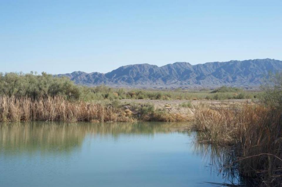
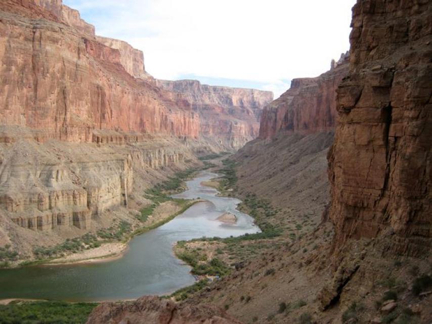
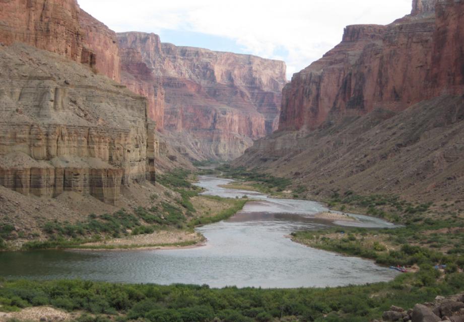
The Colorado River Delta is located at the natural terminus of the Colorado River at the Gulf of California, just south of the U.S.-Mexico border. The desert ecosystem was formed by silt flushed downstream from the Colorado and fresh and brackish water mixing at the Gulf.

The Colorado River Delta once covered 9,650 square miles but has shrunk to less than 1 percent of its original size due to human-made water diversions.

  • Read more
Aquapedia background January 30, 2014

Colorado River 2007 Interim Guidelines And Drought Contingency Plans

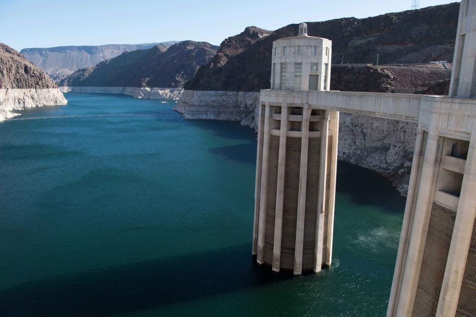
In 2005, after six years of severe drought in the Colorado River Basin, federal officials and representatives of the seven basin states — California, Arizona, Nevada, New Mexico, Colorado, Utah and Wyoming — began building a framework to better respond to drought conditions and coordinate the operations of the basin’s two key reservoirs, Lake Powell and Lake Mead.

The resulting Interim Guidelines for Lower Basin Shortages and the Coordinated Operations for Lake Powell and Lake Mead (Interim Guidelines) identified the conditions for shortage determinations and details of coordinated reservoir operations. The 2007 Interim Guidelines remain in effect through Dec. 31, 2025.

  • Read more
Aquapedia background February 11, 2014 Layperson's Guide to the Colorado River Basin Colorado River Basin Map
Humpback chubThe humpback chub is one of four endangered fish native to the Colorado River. Source: Arizona Game & Fish Department

Lower Colorado River Multispecies Conservation Program

In 2005, the Interior Department launched a program to recover 27 species in the lower Colorado River, including seven the federal government has deemed threatened or endangered or threatened with extinction. The species include fish, birds, bats, mammals, insects, amphibians, reptiles, rodents and plants

The Lower Colorado River Multispecies Conservation Program has a 50-year plan to create at least 8,132 acres of new habitat and restore habitat that has become degraded.

  • Read more
Aquapedia background January 30, 2014

Colorado River Timeline

600 Ancestral Pueblo and Hohokam Indians develop water distribution systems.

1500 Spanish explorers introduce livestock and ditch systems called acequias.

1847 Mormons arrive in the Salt Lake Valley; begin cultivating farmland.

1859 Oliver Wozencraft promotes idea of irrigating the Imperial Valley.

1865 Lower Colorado River lands begin to be set aside for American Indians.

  • Read more
Aquapedia background February 11, 2014

Colorado River Water and Mexico

The Mexican Water Treaty of 1944 committed the U.S. to deliver 1.5 million acre-feet of water to Mexico on an annual basis, plus an additional 200,000 acre-feet under surplus conditions. The treaty is overseen by the International Boundary and Water Commission.

Colorado River water is delivered to Mexico at Morelos Dam, located 1.1 miles downstream from where the California-Baja California land boundary intersects the river between the town of Los Algodones in northwestern Mexico and Yuma County, Ariz.

  • Read more
Aquapedia background January 30, 2014

Colorado River Water Use 4.4 Plan

California’s Colorado River Water Use Plan (known colloquially as the 4.4 Plan) intends to wean the state from its reliance on the surplus flows from the river and return California to its annual 4.4 million acre-feet basic apportionment of the river.

In the past, California has also used more than its basic apportionment.  Consequently, the U.S. Department of Interior urged California to devise a plan to reduce its water consumption to its basic entitlement.

  • Read more
Aquapedia background January 30, 2014

Conjunctive Use

Conjunctive use is a catch-phrase for coordinated use of surface water and groundwater— literally going with the flow to maximize sufficient yield.

  • Read more
Aquapedia background August 15, 2016

Consumptive Water Use

Diversions of water withdrawn upstream and not returned downstream as waste water.

  • Read more
Aquapedia background September 7, 2016

Contaminants

Contaminants exist in water supplies from both natural and manmade sources. Even those chemicals present without human intervention can be mobilized from introduction of certain pollutants from both point and nonpoint sources.  

  • Read more
Aquapedia background January 30, 2014

Contra Costa Canal

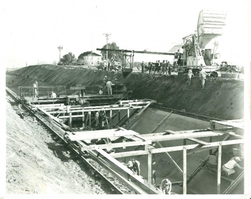
Construction began in 1937 to build the Contra Costa Canal, the first part of the federal Central Valley Project.  The Contra Costa Canal runs from the Sacramento-San Joaquin Delta, where it draws its water near Knightsen, to the eastern and central parts of Contra Costa County. It is about 30 miles from San Francisco.
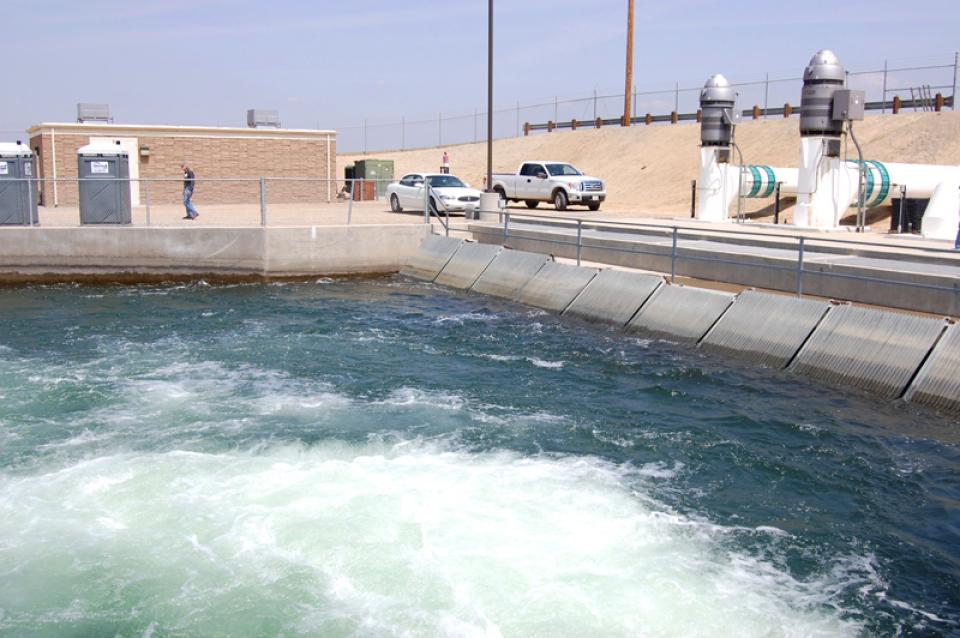
  • Read more
Aquapedia background August 15, 2016

Conveyance

Infrastructure providing for the movement of water. 

  • Read more
Aquapedia background January 30, 2014

C.W. Bill Jones Pumping Plant

The C.W. Bill Jones Pumping Plant (formerly known as the Tracy Pumping Plant) sits at the head of the 117-mile long Delta-Mendota Canal.

Completed in 1951, the canal begins near Tracy, Calif. and follows the Coast Range south, providing irrigation water to the west side of the San Joaquin Valley along its route and terminating at Mendota Pool.

  • Read more
  • « first
  • ‹ previous
  • 1
  • 2

Aquapedia

  • Alphabetical List of Subjects
    • A
    • B
    • C
    • D
    • E
    • F
    • G
    • H
    • I
    • J
    • K
    • L
    • M
    • N
    • O
    • P
    • Q
    • R
    • S
    • T
    • U
    • V
    • W
    • X
    • Y
    • Z
  • Historical Water People
  • Where Does My Water Come From?
  • Timelines
  • Videos
  • Image Gallery
  • Water Directory
  • Online Resources
  • Useful Acronyms
  • About Aquapedia
Footer pod May 20, 2014

Water Education Foundation

Copyright © 2025 Water Education Foundation. All rights reserved.

The Water Education Foundation is a nonprofit, tax-exempt, 501(c)3 organization, federal tax ID #942419885.

Privacy Policy

Donor Privacy Policy

  • Read more
Footer pod May 20, 2014

Contact Information

2151 River Plaza Drive, Suite 205
Sacramento CA 95833

Telephone (916) 444-6240

Contact Us via email

  • Read more

Quicklinks

Footer quicklink May 20, 2014

Contact Us

  • Read more
Footer quicklink May 20, 2014

Donate Today

  • Read more
Footer quicklink May 20, 2014

Tours

  • Read more
Footer quicklink May 20, 2014

Newsletter Signup

  • Read more
Footer quicklink May 20, 2014

Foundation News

  • Read more
Footer quicklink May 20, 2014

Calendar

  • Read more

Commands

  • Support portal
  • Log in
 close

Log in

  • Create new account
  • Request new password