Header link June 22, 2020

LinkedIn

  • Read more
Header link September 15, 2014

Cart

  • Read more
Header link November 3, 2015

Donate Now

  • Read more
Header link May 15, 2014

Twitter

  • Read more
Header link May 15, 2014

Facebook

  • Read more
Instagram
Header link May 15, 2014

Instagram

  • Read more
Header link May 15, 2014

Contact Us

  • Read more
More options
Water Education Foundation
Home

Water Education Foundation

Everything about California water that matters
  • Water Academy
    • Agriculture
      • Agricultural Conservation
      • Agricultural Drainage
    • Background Information
      • Legislation — California and Federal
      • Regulations — California and Federal
      • Water History
      • Water Rights
    • Bay-Delta
      • Bay Delta
      • Bay Delta Conservation Plan
      • Delta Issues
      • Delta Smelt
      • Sacramento San Joaquin Delta
      • San Francisco Bay
      • Suisun Marsh
    • Dams, Reservoirs and Water Projects
      • California Aqueduct
      • Central Valley Project
      • Folsom Dam
      • Friant Dam
      • Hetch Hetchy
      • Hoover Dam
      • Infrastructure
      • Lake Mead
      • Lake Powell
      • Oroville Dam
      • San Luis Dam
      • Shasta Dam
      • State Water Project
    • Environmental Issues
      • Anadromous Fish Restoration
      • Ecosystem
      • Endangered Species Act
      • Invasive species
      • Lake Tahoe
      • Mono Lake
      • Public Trust Doctrine
      • Salmon
      • San Joaquin River Restoration
      • Watershed
      • Wetlands
    • Leaders and Experts
    • Regions
      • Central Coast
      • Central Valley
      • Mexico
      • Nevada
      • North Coast
      • Pyramid Lake
      • Sacramento Valley
      • Salton Sea
      • San Joaquin Valley
      • Sierra Nevada
      • Southern California
      • Tulare Lake Basin
    • Rivers
      • Carson River
      • Colorado River
      • Klamath River
      • New River
      • North Coast Rivers
      • Russian River
      • Sacramento River
      • Truckee River
      • San Joaquin River
    • Water Issues
      • Climate Change
      • Coronavirus
      • Drought
      • Earthquakes
      • Energy and Water
      • Flood Management
      • Fracking
      • Growth
      • Hydropower
      • Levees
      • Tribal Water Issues
      • Water Conservation
      • Water Equity
    • Water Quality
      • Drinking Water
      • Nitrate contamination
      • Pollution
      • Stormwater
      • Wastewater
      • Water Quality
    • Water Supply and Management
      • Acre Foot
      • Aquifers
      • California Water Plan
      • Conjunctive Use
      • Desalination
      • Gray water
      • Groundwater
      • Integrated Regional Water Management
      • Recreation
      • Surface Water
      • Water Marketing and Banking
      • Water Rates
      • Water Recycling
      • Water Supply
      • Water Transfers
  • Tours & Events
    • Water Tours
      • 2022 Tour Sponsors
    • Events
    • Event Calendar
    • Past Tours & Events
      • Anne J. Schneider Fund Lecture Series
  • Specialized Programs
    • Water Leaders
      • Class Rosters
      • Yearly Class Reports
      • Your Alumni Network
      • Alumni Profiles
    • Project WET
      • Workshops
      • Special Workshops & Events
      • Supplementary Materials
      • California Content Standard Correlations
      • Facilitator's Trainings
      • Foundation School Programs
        • Elementary Programs
        • Secondary Programs
      • Water Kids
      • California Project WET Gazette
      • Gazette Archives
    • Colorado River Project
    • GRA Scholastic Fund Program
  • Maps & Guides
    • Maps & Posters
    • Layperson's Guides
    • Map & Guide Bundles
    • Books
    • Colorado River Materials
    • California Runoff Rundown
    • Other Publications
    • Water Awareness Materials
    • Downloadable Publications
    • Videos and DVDs
      • Video Clips
    • School Age Publications
    • Stickers
    • Free Programs and Publications
  • Newsroom
    • Western Water News
    • Aquafornia
      • About Aquafornia
    • Information Desk
    • Western Water Magazine Archive
      • Full Print Edition
      • Print Edition Excerpts
    • River Report Archive
  • Aquapedia
    • Alphabetical List of Subjects
      • A
      • B
      • C
      • D
      • E
      • F
      • G
      • H
      • I
      • J
      • K
      • L
      • M
      • N
      • O
      • P
      • Q
      • R
      • S
      • T
      • U
      • V
      • W
      • X
      • Y
      • Z
    • Historical Water People
    • Where Does My Water Come From?
      • Northern California
      • Sacramento
      • North Bay
      • South Bay
      • Central Valley
      • Los Angeles
      • Inland Empire
      • San Diego
      • All California Water Sources
    • Timelines
    • Videos
    • Image Gallery
    • Water Directory
      • Federal Agencies
      • State Agencies in California
      • Environmental Organizations
      • Other California Organizations
      • State and Federal Legislative Committees
      • Water Associations and Groups
      • Western States Water Agencies and Districts
    • Online Resources
    • Useful Acronyms
    • About Aquapedia
  • About
    • About Us
      • Board of Directors
      • Staff Biographies
      • Job Openings
    • Announcements
    • Support Our Mission
      • Become a Member
      • Donate in Honor/Memory
      • Donate to Aquapedia or Aquafornia
      • Shop Amazon
      • Planned Giving
    • Contact Us
Aquapedia background September 4, 2020 Colorado River Bundle

Colorado River Compact

Signing of the Colorado River Compact in 1922.The Colorado River Compact of 1922 divided the river into two basins: The Upper Basin (Colorado, New Mexico, Utah and Wyoming) and the Lower Basin (Arizona, California and Nevada), established the allotment for each basin and provided a framework for management of the river for years to come.

The Compact was and remains a historic achievement. It was the first time in U.S. history that more than three states negotiated an agreement among themselves to apportion the waters of a stream or river. The Compact is the cornerstone of the “Law of the River,” which refers to the many compacts, federal laws, court decisions and decrees, contracts and regulatory guidelines that regulate use of the Colorado River.

Prior to the Compact, most of the Basin states were anxious about securing their share of the Colorado River but could not agree on how to allocate the river among themselves.
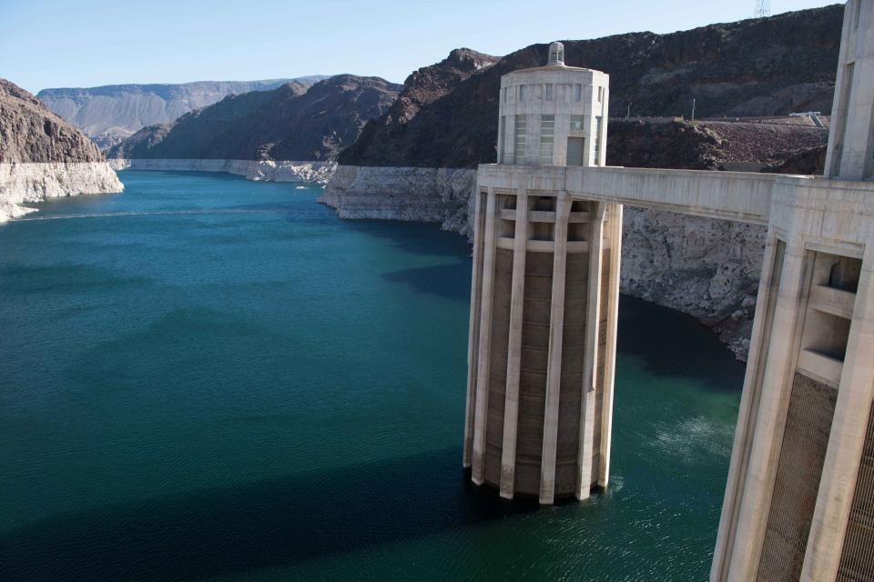
 California’s growth was viewed with concern. The other states in the Basin feared California would establish priority rights to Colorado River water. Those concerns were intensified by a June 1922 U.S. Supreme Court ruling that the law of prior appropriation – meaning whoever used the water first had first right of use in times of shortage — applied regardless of state lines.

The states proceeded to discuss an interstate compact to avert federal government intervention and avoid costly and time-consuming litigation. The Colorado River Commission was convened in January 1922 in Washington, D.C. with Herbert Hoover, then-Secretary of Commerce, as its chairman. The states, however, could not agree during that meeting on how to allocate the waters of the Colorado River Basin.

Delegates from the seven Colorado River Basin states met on Nov. 9, 1922, in New Mexico to discuss and ultimately work out the Compact, which was signed at the Palace of the Governors in Santa Fe on Nov. 24.

Lee Ferry, Arizona, 1923Based on Hoover’s suggestion, the Compact divided the river into Upper and Lower Basins with the division being at Lee Ferry, Arizona. The Compact apportioned the right to exclusive beneficial consumptive use of 7.5 million acre-feet of water from the Colorado River system in perpetuity each to the Upper Basin and the Lower Basin. This approach reserved water for future Upper Basin development and allowed planning and development in the Lower Basin to proceed.

However, the allocations were based on hydrologic data that indicated annual Colorado River flow at Lee Ferry to be 16.4 million acre-feet. The figure was later revised to be about 13.5 million acre-feet. Furthermore, Colorado River flow fluctuates greatly from year to year, between 4.4 million acre-feet to more than 22 million acre-feet.

The Compact provides that the Upper Basin states will not cause the flow of the river at Lee Ferry to be depleted below an aggregate of 75 million acre-feet for any period of 10 consecutive years. The Compact grandfathered irrigated water rights that were already in place on Colorado’s Western Slope. The Compact’s only reference to Native American water rights is a single sentence stating that nothing in the document should be understood to affect the United States government’s obligations to tribal water rights.

Colorado River water for Mexico was addressed in the 1944 treaty between the U.S. and Mexico.

Although the 1922 Compact was signed by each of the seven Basin states, Arizona did not ratify it until 1944. Arizona had faulted the Compact for not allocating water directly to the states, instead of to the basins.

Specific allocations for each state were established later. The Lower Basin states were given their annual allocations in 1928 as part of the Boulder Canyon Project Act, which also  authorized construction of what became known as Hoover Dam. The annual allotments in the Upper Basin were established later by the Upper Colorado River Basin Compact of 1948.

  • Print-friendly

Referring Pages

Share this page

  • Share on Facebook
  • Share on Twitter
  • Share on LinkedIn
  • Sent to a friend.
Print-friendly

Related Links

Aquapedia background September 4, 2020 Colorado River Bundle
Maps & Posters January 8, 2019

Colorado River Bundle
Special discount price for Colorado River Basin map and Layperson’s Guide to the Colorado River

The Colorado River bundle features our beautiful Colorado River poster-size map and our Colorado River Layperson’s Guide, updated in 2018. This bundle gives you the resources you need to understand the importance of the Colorado River to nearly 40 million people in seven Western states and Mexico.

Regularly priced at $22 for the map and $15 for the guide, this bundle allows you to purchase both of these high-quality products for $32. Add the Layperson’s Guide to the Colorado River Delta for an additional $7.50, using the discount code COLORADODELTA. Please note the map ships separately from the guides.

  • Read more
Back
This item appears in:
  • Topic: Colorado River
  • C
  • Topic: Hoover Dam
Footer pod May 20, 2014

Water Education Foundation

Copyright © 2022 Water Education Foundation. All rights reserved.

The Water Education Foundation is a nonprofit, tax-exempt, 501(c)3 organization, federal tax ID #942419885.

Privacy Policy

Donor Privacy Policy

  • Read more
Footer pod May 20, 2014

Contact Information

2151 River Plaza Drive, Suite 205
Sacramento CA 95833

Telephone (916) 444-6240

Contact Us via email

  • Read more

Quicklinks

Footer quicklink May 20, 2014

Contact Us

  • Read more
Footer quicklink May 20, 2014

Donate Today

  • Read more
Footer quicklink May 20, 2014

Tours

  • Read more
Footer quicklink May 20, 2014

Newsletter Signup

  • Read more
Footer quicklink May 20, 2014

Foundation News

  • Read more
Footer quicklink May 20, 2014

Calendar

  • Read more

Log in

  • Create new account
  • Request new password

Commands

  • Support portal
  • Log in