Header link June 22, 2020

LinkedIn

  • Read more
Header link September 15, 2014

Cart

  • Read more
Header link November 3, 2015

Donate Now

  • Read more
Header link May 15, 2014

Twitter

  • Read more
Header link May 15, 2014

Facebook

  • Read more
Instagram
Header link May 15, 2014

Instagram

  • Read more
Header link May 15, 2014

Contact Us

  • Read more
More options
Water Education Foundation
Home

Water Education Foundation

Everything about California water that matters
  • Water Academy
    • Agriculture
      • Agricultural Conservation
      • Agricultural Drainage
    • Background Information
      • Legislation — California and Federal
      • Regulations — California and Federal
      • Water History
      • Water Rights
    • Bay-Delta
      • Bay Delta
      • Bay Delta Conservation Plan
      • Delta Issues
      • Delta Smelt
      • Sacramento San Joaquin Delta
      • San Francisco Bay
      • Suisun Marsh
    • Dams, Reservoirs and Water Projects
      • California Aqueduct
      • Central Valley Project
      • Folsom Dam
      • Friant Dam
      • Hetch Hetchy
      • Hoover Dam
      • Infrastructure
      • Lake Mead
      • Lake Powell
      • Oroville Dam
      • San Luis Dam
      • Shasta Dam
      • State Water Project
    • Environmental Issues
      • Anadromous Fish Restoration
      • Ecosystem
      • Endangered Species Act
      • Invasive species
      • Lake Tahoe
      • Mono Lake
      • Public Trust Doctrine
      • Salmon
      • San Joaquin River Restoration
      • Watershed
      • Wetlands
    • Leaders and Experts
    • Regions
      • Central Coast
      • Central Valley
      • Mexico
      • Nevada
      • North Coast
      • Pyramid Lake
      • Sacramento Valley
      • Salton Sea
      • San Joaquin Valley
      • Sierra Nevada
      • Southern California
      • Tulare Lake Basin
    • Rivers
      • Carson River
      • Colorado River
      • Klamath River
      • New River
      • North Coast Rivers
      • Russian River
      • Sacramento River
      • Truckee River
      • San Joaquin River
    • Water Issues
      • Climate Change
      • Coronavirus
      • Drought
      • Earthquakes
      • Energy and Water
      • Floods
      • Fracking
      • Growth
      • Hydropower
      • Levees
      • Tribal Water Issues
      • Water Conservation
      • Water Equity
    • Water Quality
      • Drinking Water
      • Nitrate contamination
      • Pollution
      • Stormwater
      • Wastewater
      • Water Quality
    • Water Supply and Management
      • Acre Foot
      • Aquifers
      • California Water Plan
      • Conjunctive Use
      • Desalination
      • Grey water
      • Groundwater
      • Integrated Regional Water Management
      • Recreation
      • Surface Water
      • Water Marketing and Banking
      • Water Rates
      • Water Recycling
      • Water Supply
      • Water Transfers
  • Tours & Events
    • Water Tours
      • 2023 Tour Sponsors
    • Events
    • Event Calendar
    • Past Tours & Events
      • Anne J. Schneider Fund Lecture Series
  • Specialized Programs
    • Water Leaders
      • Class Rosters
      • Yearly Class Reports
      • Your Alumni Network
      • Alumni Profiles
    • Project WET
      • Workshops
      • Special Workshops & Events
      • Supplementary Materials
      • California Content Standard Correlations
      • Facilitator's Trainings
      • Foundation School Programs
        • Elementary Programs
        • Secondary Programs
      • Water Kids
      • California Project WET Gazette
      • Gazette Archives
    • Colorado River Project
    • GRA Scholastic Fund Program
  • Maps & Guides
    • Maps & Posters
    • Layperson's Guides
    • Map & Guide Bundles
    • Books
    • Colorado River Materials
    • California Runoff Rundown
    • Other Publications
    • Water Awareness Materials
    • Downloadable Publications
    • Videos and DVDs
      • Video Clips
    • School Age Publications
    • Stickers
    • Free Programs and Publications
  • Newsroom
    • Western Water News
    • Aquafornia
      • About Aquafornia
    • Information Desk
    • Western Water Magazine Archive
      • Full Print Edition
      • Print Edition Excerpts
    • River Report Archive
  • Aquapedia
    • Alphabetical List of Subjects
      • A
      • B
      • C
      • D
      • E
      • F
      • G
      • H
      • I
      • J
      • K
      • L
      • M
      • N
      • O
      • P
      • Q
      • R
      • S
      • T
      • U
      • V
      • W
      • X
      • Y
      • Z
    • Historical Water People
    • Where Does My Water Come From?
      • Northern California
      • Sacramento
      • North Bay
      • South Bay
      • Central Valley
      • Los Angeles
      • Inland Empire
      • San Diego
      • All California Water Sources
    • Timelines
    • Videos
    • Image Gallery
    • Water Directory
      • Federal Agencies
      • State Agencies in California
      • Environmental Organizations
      • Other California Organizations
      • State and Federal Legislative Committees
      • Water Associations and Groups
      • Western States Water Agencies and Districts
    • Online Resources
    • Useful Acronyms
    • About Aquapedia
  • About
    • About Us
      • Board of Directors
      • Staff Biographies
      • Job Openings
    • Announcements
    • Support Our Mission
      • Become a Member
      • Donate in Honor/Memory
      • Donate to Aquapedia or Aquafornia
      • Shop Amazon
      • Planned Giving
    • Contact Us
Aquapedia background February 11, 2014 Dams Layperson's Guide to the Central Valley Project California Water Map

Shasta Dam

Image shows Shasta Dam from a distance, with the reservoir largely filled.Shasta Dam forms California’s largest storage reservoir, Shasta Lake, which can hold about 4.5 million acre-feet.

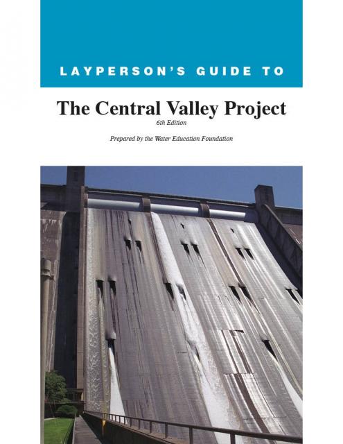
As the keystone of the federal Central Valley Project, Shasta stands among the world’s largest dams. Construction on the dam began in 1938 and was completed in 1945, with flood control as the highest priority.

Located 12 miles north of Redding, Shasta traps the cold waters of the Pit and McCloud rivers and the headwaters of the Sacramento River behind its 602-foot curved, concrete face. Roughly 90 percent of the water stored in Shasta Lake comes from rainfall. The reservoir accounts for about 41 percent of the stored water in the Central Valley Project. 

In years of normal precipitation, the Central Valley Project stores and distributes about 20 percent of the state’s developed water — about 7 million acre-feet —through its massive system of reservoirs and canals. Water is transported 450 miles from Lake Shasta in Northern California to Bakersfield in the southern San Joaquin Valley. Along the way, the Central Valley Project has long-term agreements with more than 250 contractors in 29 of California’s 58 counties.

Shasta Dam and Operations

Associated facilities include Shasta Powerplant, located just below the dam, with a generating capacity of 710,000 kilowatts, or enough power to meet the needs of between 355,000 and 710,000 homes.

Ten miles downstream is Keswick Dam, reservoir and power plant. Keswick Dam creates an afterbay for Shasta Dam and the Trinity River diversion facilities, stabilizing uneven water releases from the power plants.

As with most multipurpose projects, the CVP’s operational priorities change with the seasons. From November to April, flood control is the top priority and reservoirs are filled to store winter runoff. From May to October, releases are timed to satisfy a variety of water-supply needs and create room for flood flows. At Shasta, the reservoir typically is drawn down to a flood reservation volume by early December, and maximum storage is normally reached in late May or June.

Similar to the Oroville Dam, construction of Shasta Dam blocked access to 187 miles of cold water streams, about half the available spawning and rearing habitat in the upper Sacramento River system.

Watch a video about the history of Shasta Dam and the Central Valley Project.

During Shasta’s construction, the U.S. Fish and Wildlife Service worked with the Bureau of Reclamation to mitigate this habitat loss. Coleman National Fish Hatchery, located near the mouth of Battle Creek where it joins the Sacramento River, was built in 1943 to offset the loss of anadromous fish that could no longer reach their spawning grounds upstream of Shasta.

Livingston Stone National Fish Hatchery at the base of Shasta Dam was established in 1997. It is the only hatchery in the world that raises winter-run chinook salmon and is one of two captive brood stock programs for Delta smelt in California.

Today, there are three types of migratory barriers to anadromous fish within Battle Creek: natural waterfalls, hydroelectric diversion dams, and the Coleman Hatchery weir.

There are efforts underway to restore and enhance the endangered winter-run chinook salmon.

Reclamation made numerous operational changes. A temperature control device on the upstream face of Shasta Dam releases varying amounts of water from three depths (to a maximum depth of 350 feet) to maintain favorable downstream temperatures for spawning fish. Other actions include closing the Delta Cross Channel gates for several months to keep migrating salmon in the river channel.

Shasta Dam and the Future

The photo shows the Sacramento River as it flows beyond Shasta Dam and its powerhouse. According to Reclamation, enlarging the reservoir would improve water supply reliability, reduce flood damages and improve water temperatures in the Sacramento River below the dam for anadromous fish survival.

Raising the dam 18.5 feet, for example, would mean an additional 636,000 acre-feet a year, enough water to sustain 2 million people a year. Opponents say the amount of water made available by raising the dam is not worth the ecosystem costs —flooding of canyons and endangering wildlife and habitat —and further loss of sacred tribal ground (an issue unresolved from the original construction).

Congress in 2018 set aside $20 million for design and preconstruction work on the project. The state of California went to court in 2019 to block CVP contractor Westlands Water District from assisting in the planning and construction of a dam raise. A subsequent ruling granted a preliminary injunction halting Westlands’ participation in the project. California opposes the project because it would inundate a reach of the McCloud River, which is designated as a California wild and scenic river.

Meanwhile, the Bureau of Reclamation is conducting the Shasta Lake Water Resources Investigation to evaluate enlarging Shasta Dam and Reservoir. As the investigation progresses, Reclamation plans to continue related work on environment, water rights and Native American and cultural resources.

  • Print-friendly

Referring Pages

Aquapedia background February 11, 2014 Dams Shasta Dam

Trinity Dam and Trinity River

Though seemingly a long-way from California’s Central Valley, the Trinity Dam helps supply irrigation water for Valley farmers and for hydropower production.

Constructed in the far northwest of California in the 1950s, Trinity Dam and Lewiston Dam, just downstream, increased the storage capacity of the federal Central Valley Project by more than 2.5 million acre-feet.

  • Read more
Aquapedia background February 3, 2014 Oroville Dam Shasta Dam Hoover Dam Layperson's Guide to the Central Valley Project Layperson's Guide to the State Water Project

Dams

Folsom Dam on the American River east of Sacramento

Dams have allowed Californians and others across the West to harness and control water dating back to pre-European settlement days when Native Americans had erected simple dams for catching salmon.

  • Read more

Share this page

  • Share on Facebook
  • Share on Twitter
  • Share on LinkedIn
  • Sent to a friend.
Print-friendly

Related Links

Aquapedia background February 11, 2014 Dams Layperson's Guide to the Central Valley Project California Water Map
Folsom Dam on the American River east of Sacramento
Aquapedia background February 3, 2014 Oroville Dam Shasta Dam Hoover Dam Layperson's Guide to the Central Valley Project Layperson's Guide to the State Water Project

Dams

Dams have allowed Californians and others across the West to harness and control water dating back to pre-European settlement days when Native Americans had erected simple dams for catching salmon.

  • Read more
Publication May 20, 2014

Layperson’s Guide to the Central Valley Project
Updated 2021

The 24-page Layperson’s Guide to the Central Valley Project explores the history and development of the federal Central Valley Project (CVP), California’s largest surface water delivery system. In addition to the project’s history, the guide describes the various CVP facilities, CVP operations, the benefits the CVP brought to the state and the CVP Improvement Act (CVPIA).

  • Read more
Maps & Posters April 17, 2014 California Water Bundle

California Water Map
Updated December 2016

A new look for our most popular product! And it’s the perfect gift for the water wonk in your life.

Our 24×36 inch California Water Map is widely known for being the definitive poster that shows the integral role water plays in the state. On this updated version, it is easier to see California’s natural waterways and man-made reservoirs and aqueducts – including federally, state and locally funded projects – the wild and scenic rivers system, and natural lakes. The map features beautiful photos of California’s natural environment, rivers, water projects, wildlife, and urban and agricultural uses and the text focuses on key issues: water supply, water use, water projects, the Delta, wild and scenic rivers and the Colorado River.

  • Read more
Back
This item appears in:
  • Topic: Shasta Dam
  • S
Footer pod May 20, 2014

Water Education Foundation

Copyright © 2023 Water Education Foundation. All rights reserved.

The Water Education Foundation is a nonprofit, tax-exempt, 501(c)3 organization, federal tax ID #942419885.

Privacy Policy

Donor Privacy Policy

  • Read more
Footer pod May 20, 2014

Contact Information

2151 River Plaza Drive, Suite 205
Sacramento CA 95833

Telephone (916) 444-6240

Contact Us via email

  • Read more

Quicklinks

Footer quicklink May 20, 2014

Contact Us

  • Read more
Footer quicklink May 20, 2014

Donate Today

  • Read more
Footer quicklink May 20, 2014

Tours

  • Read more
Footer quicklink May 20, 2014

Newsletter Signup

  • Read more
Footer quicklink May 20, 2014

Foundation News

  • Read more
Footer quicklink May 20, 2014

Calendar

  • Read more

Log in

  • Create new account
  • Request new password

Commands

  • Support portal
  • Log in