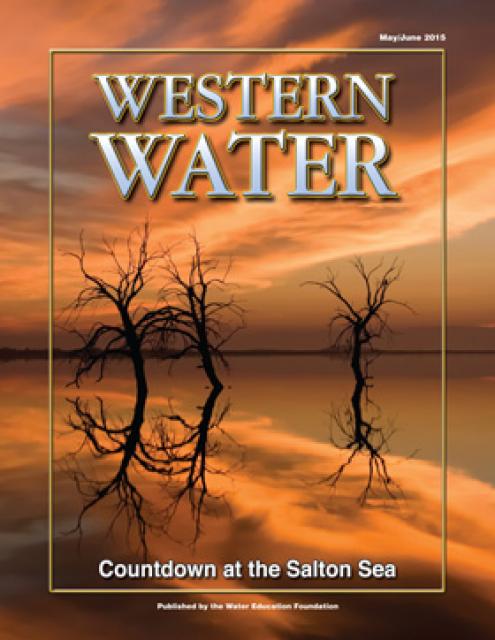
The prevailing goal in Southern California has been to get
water that falls from the sky away from our roads and buildings
as quickly as possible. Much of the rain washes out to the
ocean — often carrying trash and other pollutants. The L.A.
Times reported up to 10 billion gallons poured into the Los
Angeles Basin in recent storms and only about 20% will be
captured. L.A. County has plans to double the amount
of rainwater currently captured every year and use it
to provide nearly two-thirds of the county’s drinking
water. Voters approved a new property tax in 2018
meant to raise up to $300 million a year to fund the capture
and treatment of stormwater.
My umbrella was wide and sturdy, my rain slicker insulated and
as yellow as a Minion. I wore thick Dickies and my good pair of
Doc Martens. It didn’t matter. Just minutes after I stepped out
of my Yukon to walk around Parque de los Niños in Placentia’s
Atwood barrio last week, I was thoroughly soaked. A strong wind
made the rain whip at a 45-degree angle. Drops hit the baseball
diamond with such force that mud leaped into the air.
… Eighty-five years ago this March, this historic
Mexican American neighborhood took the brunt of the deadliest
flood in Southern California history. Five days of heavy storms
caused all of the region’s major rivers — the Los Angeles, the
San Gabriel and especially the Santa Ana — to overflow their
banks. -Written by Gustavo Arellano, columnist for the
Los Angeles Times.
As a series of storms continues to pummel California, officials
say the havoc is a testament to the unexpected ferocity of
extreme weather. By Tuesday evening, at least 17 people have
been killed in circumstances directly related to a train of
atmospheric rivers that has inundated the state since New
Year’s Eve, bringing the death toll from the storms higher than
the last two wildfire seasons combined….The deadly weather is
foiling evacuation plans and straining the state’s aging
infrastructure as strong winds topple power lines and fast
rising waters overtop levees. Officials say the storms
highlight the way in which climate change is increasingly
catching people off guard as the state swings from one extreme
weather event to another, leaving little time to prepare.
California’s vulnerability to destructive flooding is anything
but a secret. Meteorologists and climatologists have been
warning of the enhanced risk for years, as climate change
drives the state through cycles of extreme drought and then
warms the winter air to produce violent downpours like the bomb
cyclone and atmospheric river events of the past few weeks. The
effects are felt up and down the map, including in key
agricultural areas and low-lying rural patches. But they are
not felt equally—another reality experts have been speaking
about for some time. The worst of California’s flood woes, both
this month and into the long future, will be visited upon the
state’s poorest residents.
It wasn’t so long ago that California prayed for rain.
Something to quench the climate-change-fueled drought — the
worst in at least 1,200 years — that has caused farm fields to
wither and wells to run dry…. Now, the water that
Californians so desperately wanted is pummeling them like a
curse….The recent onslaught of atmospheric rivers has
underscored the perils of California’s climate paradox: Rising
global temperatures are making the region drier, hotter and
more fire-prone, but they also increase the likelihood of
sudden, severe rainfall. Experts say the state is not prepared
for periods of too much water, even as it struggles to make do
without enough.
Adán Ortega, Jr. took the helm today of Metropolitan Water
District’s Board of Directors as the 20th chair and first
Latino to lead the board in the district’s 95-year
history. In addition to his installation, Ortega welcomed
three new directors who took their seats to represent the
Calleguas, Central Basin and Eastern municipal water districts
on the 38-member board. Ortega, who has represented the city of
San Fernando on the board since March 2021, took his oath of
office in a boardroom filled with family, elected officials,
community leaders, mentors and friends.
Downpours from an atmospheric river storm triggered landslides
in the Santa Cruz Mountains Monday, burying highways in heaps
of mud and trapping residents in place. The damage is the
consequence of weeks of rain fueled by atmospheric rivers.
… Rain is one of the primary forces that trigger
landslides. As water trickles into the tiny gaps between soil
and rocks, it adds pressure, which makes soils more
unstable. … The New Year’s Eve storm produced
hundreds of landslides across the Bay Area, with a focus in the
East Bay, Collins said. This week in the Santa Cruz
Mountains, waterlogged soil from weeks of frequent rain is
breaking free from deeper layers of earth and slipping down
slopes onto roads.
One apparently is hiding under the driveway of a million-dollar
home in Placentia. Another lurks beneath a parking lot at
Ontario International Airport. And another is under a
commercial building in Culver City — much to the surprise of
the upscale window company doing business there. Thanks to its
once expansive, 150-year-old oil and gas industry, Southern
California has one of the nation’s highest concentrations of
so-called “orphan wells,” or wells that companies abandoned
without first plugging them up for safety. The state has
documented nearly 2,000 orphan wells in Los Angeles, Orange,
San Bernardino and Riverside counties alone, while estimating
that thousands more could be paved over, unrecorded, and
waiting to be rediscovered.
The Imperial Irrigation District is pleased to announce
director Gina Dockstader’s appointment to the California Farm
Water Coalition (CFWC). According to a press release from the
IID, Director Dockstader was selected by her fellow IID board
members to serve as a liaison between IID and the California
Farm Water Coalition. The CFWC is a 501(c)(3) nonprofit
directed by a volunteer board of directors, representing
agriculture across the state. Its mission is to increase public
awareness of agriculture’s use of water and provide a common,
unifying voice for agricultural water users by serving as the
voice for agricultural water users, representing irrigated
agriculture in the media and educating the public about the
benefits of irrigated agriculture, the release states.
NOAA’s hurricane hunters might be just as busy now as they were
during hurricane season. However, it’s not hurricanes they are
flying through, but the atmospheric river systems plaguing
California since Christmas week. Atmospheric rivers may not
make headlines in the same way hurricanes do, but they can have
extreme consequences. “Atmospheric rivers can span the whole
Pacific. They are long and narrow, but they’re way larger than
hurricanes,” Atmospheric River Reconnaissance Coordinator Anna
Wilson said. They are crucial to the West Coast. Half the rain
and snow the West gets comes from atmospheric rivers, which are
plumes of moisture coming in from the Pacific Ocean. And they
cross an area with very few observation sites, making them
challenging to forecast.
A powerful winter storm barreled into Southern California on
Monday, forcing the mass evacuation of Montecito and other
communities exactly five years after mudslides in the same area
left 23 people dead. Pounding rain wreaked havoc throughout the
coastal counties north of Los Angeles, bringing flooding, road
closures and tragedy, including the death of a motorist who
entered a flooded roadway and the presumed death of a
5-year-old boy who was swept away by flood waters in San Luis
Obispo County. The storm, which was expected to move through
Los Angeles, Orange and other southern counties through
Tuesday, dumped more than 16 inches of rain in some mountain
areas Monday and prompted pleas for people to stay indoors.
The U.S. and Mexico share underground water basins that span
more than 121,500 square miles of the Borderlands. But the two
countries have no regulations for managing those common
aquifers, in part, because historically very little was known
about them. That’s changing. On Dec. 28,
researchers released the first complete map of the
groundwater basins that span the U.S.-Mexico
boundary…. With water becoming an increasingly precious
resource in the southwestern U.S. and northern Mexico, the
researchers hope the new map will provide a basis for
developing a binational legal framework to regulate the
underground waters’ management…. It shows five shared
aquifers between Baja California and California, 26 between
Sonora and Arizona, and 33 between Texas and the Mexican states
of Chihuahua, Coahuila, Nuevo León, and Tamaulipas.
Following three consecutive atmospheric rivers, much of
California’s drought-ridden landscape is now drenched. Although
these storms resulted in flooded highways and downed trees, one
silver lining is the possibility of a “superbloom” that may hit
California’s arid interior this spring. Superblooms
are a relatively rare occurrence, even in a state renowned for
colorful wildflowers and diverse plant ecosystems. Following
heavy winter rains, annual or short-lived perennial flowers
will bloom briefly—and all at once—in the spring. The event,
which last happened in 2019, creates cascades of native flowers
in regions across California, turning rolling hills and valleys
rainbow-colored.
As rain has deluged our parched state since New Year’s Eve,
many Californians have found themselves asking a familiar
question: Is this somehow because of El Niño? In the California
imagination, the climate pattern known as El Niño has an almost
mythological status as a harbinger of prolonged wet spells,
while its counterpart, La Niña, is associated with drought. The
past three years have been La Niña years. The continuing
procession of storms this winter has drawn comparisons to the
famed wet winter of 1997-98, when rain driven by El Niño
drenched the Golden State. Californians are bracing for one of
the season’s most intense storms to date on Monday and Tuesday.
But Daniel L. Swain, a climate scientist at the University of
California, Los Angeles, said that El Niño hasn’t taken over —
yet.
The torrential rainfall across much of central and northern
California may have helped to pull a tiny piece of the state
out of drought. Data from the U.S. Drought Monitor shows that
while 97.93 percent of California is experiencing some degree
of drought, the remaining 2.07 percent is only classified as
“abnormally dry.” … However, a lot more rain would be
needed to drag California out of its
decades-long megadrought, as short-term fluctuations in
how dry an area is at a given time is drastically different to
the long-term trend of dryness across the state.
Big waves – some topping 18 feet in Los Angeles County –
wreaked havoc on Friday, Jan. 6, as high tides and a winter
swell continued to work over the Southern California coastline
leading to beach erosion, pier closures, crumbled asphalt
parking lots and boats torn from their docks. In the South Bay,
piers at three west-facing beaches remained closed Friday as
waves more than 15 feet tall pummeled the structures.
… Additionally, the high surf and tide surge swamped a
block jetty at Cabrillo Beach in San Pedro, flooding and
closing the nearby parking lot. Mounds of sand buried a bike
path that runs from Torrance Beach to Avenue H in Redondo Beach
and sea water flooded into a parking lot and public bathroom
facility.
The Los Angeles River roared to life this week as a series of
powerful storms moved through the Southland. In Long Beach, 3
feet of water shut down the 710 Freeway in both directions,
while flooding in the San Fernando Valley forced the closure of
the Sepulveda Basin. It was by all accounts a washout, but
despite heaps of water pouring into the area, drought-weary Los
Angeles won’t be able to save even half of it. The region’s
system of engineered waterways is designed to whisk L.A.’s
stormwater out to sea — a strategy intended to reduce flooding
that nonetheless sacrifices countless precious gallons.
The atmospheric river storm hitting California this week
presents a test for an experimental waste-capturing system
that’s intended to keep plastic bottles, diapers and other
trash from flowing into the Pacific. It has even captured a
couch. The solar-powered system, designed to work mostly
autonomously, was introduced in October at the mouth of Ballona
Creek near Playa del Rey.
Philip Robert Williams, 62, of Lake Elsinore passed away on
November 20, 2022, in Temecula CA. Phil was born September 9,
1960, to Robert Golden and Marica Lynne (Strickland) Williams.
Phil married Tammy Simon on December 18, 1982. Phil was a
lifelong resident of the Lake Elsinore Valley. … Phil
was a Special District Member of Riverside LAFCO, he served on
the Lake Elsinore and San Jacinto Watersheds Authority JPA,
Bedford-Coldwater Groundwater Sustainability Agency JPA,
Countywide RDA Oversight Board, and the Association of
California Water Agencies Joint Powers Insurance Authority
JPIA.
Not building the controversial Delta tunnel means Southern
California and Bay Area cities would need to invest in
desalination plants and groundwater recharge of brackish water
that could impact the visual pleasantries of coastal scenery.
That is the bottom line buried in the no-project alternative of
the Army Corps of Engineers’ latest 691-page Environmental
Impact Study on the proposed Delta tunnel study released in
late December. The report determined building the tunnel will
have major impacts on San Joaquín County as well as the
Northern San Joaquin Valley including agricultural, local water
supply, air quality, endangered species, and essential fish
habitat…. The Army Corps of Engineers has declined to
hold any in-person hearings for feedback on the study whose
comment period ends Feb. 14, 2002. That fact has drawn a sharp
rebuke from Congressman Josh Harder.