Header link June 22, 2020

LinkedIn

  • Read more
Header link September 15, 2014

Cart

  • Read more
Header link November 3, 2015

Donate Now

  • Read more
Header link May 15, 2014

Twitter

  • Read more
Header link May 15, 2014

Facebook

  • Read more
Instagram
Header link May 15, 2014

Instagram

  • Read more
Header link May 15, 2014

Contact Us

  • Read more
More options
Water Education Foundation
Home

Water Education Foundation

Everything about California water that matters
  • Water Academy
    • Agriculture
      • Agricultural Conservation
      • Agricultural Drainage
    • Background Information
      • Legislation — California and Federal
      • Regulations — California and Federal
      • Water History
      • Water Rights
    • Bay-Delta
      • Bay Delta
      • Bay Delta Conservation Plan
      • Delta Issues
      • Delta Smelt
      • Sacramento San Joaquin Delta
      • San Francisco Bay
      • Suisun Marsh
    • Dams, Reservoirs and Water Projects
      • California Aqueduct
      • Central Valley Project
      • Folsom Dam
      • Friant Dam
      • Hetch Hetchy
      • Hoover Dam
      • Infrastructure
      • Lake Mead
      • Lake Powell
      • Oroville Dam
      • San Luis Dam
      • Shasta Dam
      • State Water Project
    • Environmental Issues
      • Anadromous Fish Restoration
      • Ecosystem
      • Endangered Species Act
      • Invasive species
      • Lake Tahoe
      • Mono Lake
      • Public Trust Doctrine
      • Salmon
      • San Joaquin River Restoration
      • Watershed
      • Wetlands
    • Leaders and Experts
    • Regions
      • Central Coast
      • Central Valley
      • Mexico
      • Nevada
      • North Coast
      • Pyramid Lake
      • Sacramento Valley
      • Salton Sea
      • San Joaquin Valley
      • Sierra Nevada
      • Southern California
      • Tulare Lake Basin
    • Rivers
      • Carson River
      • Colorado River
      • Klamath River
      • New River
      • North Coast Rivers
      • Russian River
      • Sacramento River
      • Truckee River
      • San Joaquin River
    • Water Issues
      • Climate Change
      • Coronavirus
      • Drought
      • Earthquakes
      • Energy and Water
      • Flood Management
      • Fracking
      • Growth
      • Hydropower
      • Levees
      • Tribal Water Issues
      • Water Conservation
      • Water Equity
    • Water Quality
      • Drinking Water
      • Nitrate contamination
      • Pollution
      • Stormwater
      • Wastewater
      • Water Quality
    • Water Supply and Management
      • Acre Foot
      • Aquifers
      • California Water Plan
      • Conjunctive Use
      • Desalination
      • Grey water
      • Groundwater
      • Integrated Regional Water Management
      • Recreation
      • Surface Water
      • Water Marketing and Banking
      • Water Rates
      • Water Recycling
      • Water Supply
      • Water Transfers
  • Tours & Events
    • Water Tours
      • 2023 Tour Sponsors
    • Events
    • Event Calendar
    • Past Tours & Events
      • Anne J. Schneider Fund Lecture Series
  • Specialized Programs
    • Water Leaders
      • Class Rosters
      • Yearly Class Reports
      • Your Alumni Network
      • Alumni Profiles
    • Project WET
      • Workshops
      • Special Workshops & Events
      • Supplementary Materials
      • California Content Standard Correlations
      • Facilitator's Trainings
      • Foundation School Programs
        • Elementary Programs
        • Secondary Programs
      • Water Kids
      • California Project WET Gazette
      • Gazette Archives
    • Colorado River Project
    • GRA Scholastic Fund Program
  • Maps & Guides
    • Maps & Posters
    • Layperson's Guides
    • Map & Guide Bundles
    • Books
    • Colorado River Materials
    • California Runoff Rundown
    • Other Publications
    • Water Awareness Materials
    • Downloadable Publications
    • Videos and DVDs
      • Video Clips
    • School Age Publications
    • Stickers
    • Free Programs and Publications
  • Newsroom
    • Western Water News
    • Aquafornia
      • About Aquafornia
    • Information Desk
    • Western Water Magazine Archive
      • Full Print Edition
      • Print Edition Excerpts
    • River Report Archive
  • Aquapedia
    • Alphabetical List of Subjects
      • A
      • B
      • C
      • D
      • E
      • F
      • G
      • H
      • I
      • J
      • K
      • L
      • M
      • N
      • O
      • P
      • Q
      • R
      • S
      • T
      • U
      • V
      • W
      • X
      • Y
      • Z
    • Historical Water People
    • Where Does My Water Come From?
      • Northern California
      • Sacramento
      • North Bay
      • South Bay
      • Central Valley
      • Los Angeles
      • Inland Empire
      • San Diego
      • All California Water Sources
    • Timelines
    • Videos
    • Image Gallery
    • Water Directory
      • Federal Agencies
      • State Agencies in California
      • Environmental Organizations
      • Other California Organizations
      • State and Federal Legislative Committees
      • Water Associations and Groups
      • Western States Water Agencies and Districts
    • Online Resources
    • Useful Acronyms
    • About Aquapedia
  • About
    • About Us
      • Board of Directors
      • Staff Biographies
      • Job Openings
    • Announcements
    • Support Our Mission
      • Become a Member
      • Donate in Honor/Memory
      • Donate to Aquapedia or Aquafornia
      • Shop Amazon
      • Planned Giving
    • Contact Us
Aquapedia background February 11, 2014

Seawater Intrusion

Seawater intrusion can harm groundwater quality in a variety of places, both coastal and inland, throughout California.

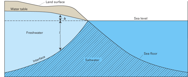
Along the coast, seawater intrusion into aquifers is connected to overdrafting of groundwater. Additionally, in the interior, groundwater pumping can draw up salty water from ancient seawater isolated in subsurface sediments.

As pumps draw up freshwater from the aquifer, seawater flows inland into the aquifer by the force of the ocean. The flow of salty water can in turn create water quality problems.

Seawater Intrusion Overview

Along the coast, seawater intrusion began to occur in the 1920s in Ventura, Los Angeles and Orange counties in Southern California, where well water was the only available supply for many communities.

Since the 1920s, water managers in those areas have taken steps to push the salty water back toward the Pacific, and to restore and expand the ability of coastal aquifers to meet water needs.

In the 1950s and 1960s, for instance, water managers in Southern California began recharging the groundwater with water imported from the Colorado River and Northern California. The recharge water creates a hydraulic barrier between the fresh water aquifer and the intruding seawater. As water demands increased, managers in Orange County took the next step of using highly treated recycled water to maintain the barrier.

And in Los Angeles County, the West and Central Basin water districts oversee a series of seawater intrusion recharge wells that provide a hydraulic barrier of fresh water along the coast. The barrier water, which undergoes an extensive treatment process, meets or exceeds California and U.S. Environmental Protection Agency standards for drinking water. 

Meanwhile, in the 1990s, the Orange County Water District and the Orange County Sanitation District joined efforts to ensure water reliability by developing a water purification program. The program takes highly treated wastewater that would have previously been discharged into the Pacific Ocean and purifies it to near-distilled-quality water.

The Salinas and Pajaro river valleys of Central California’s coast have also struggled with a serious seawater intrusion problem.

Fifty years of overdraft in the Salinas Valley have allowed the seawater to move five miles inland contaminating coastal groundwater aquifers and threatening the water supply for a $4 billion agricultural economy and the public water source for communities around Salinas.

Decades ago, Nacimiento and San Antonio reservoirs were constructed high in the Salinas River watershed to capture runoff, release it slowly and encourage groundwater recharge throughout the Salinas Valley. But irrigated agriculture in the upper valley increased, and recharge to the confined aquifers near the coast was too slow to be effective. To address the problem, the Monterey County Water Resources Agency began delivering recycled water to agricultural water users near the coast in 1998. And in 2010, the Salinas Valley Water Project completed an inflatable rubber dam near Salinas to capture more water while allowing fish to pass during wet periods.

Additionally, the northern San Joaquin Valley near Stockton has problems with pockets of seawater that pumps have drawn into the fresh water aquifers. In the northern Sacramento Valley, some pumpers are at risk of tapping into ancient deposits of seawater, which can degrade the quality of the groundwater.

And in one case, overpumping resulted in land subsidence and seawater intrusion – only the seawater was not about to invade the aquifer, but the city streets in Santa Clara County.

Santa Clara County grew by tapping the groundwater under the valley south of San Francisco Bay for agricultural irrigation, domestic and municipal supply. By the 1930s, the ground underneath the city of San Jose began to sink – raising the possibility that tidal water could inundate the community.

Since then, through the conjunctive management of surface water and groundwater, subsidence in the area has largely been halted at 13 feet. The district can adjust the water rates for surface water and groundwater to ensure the groundwater basin is protected from overdraft.

Seawater Intrusion Going Forward

A chief concern for the future is sea level rise as a result of climate change.

The California Department of Water Resources estimates that the sea levels near San Francisco rose by more than 0.6 feet in the 20th century. Based on 12 future climate scenarios, as air temperatures increase in the future, projections for global sea level rise are 0.4 feet to 1.2 feet at mid-21st century and 1.4 feet to 3.9 feet by the end of the century.  Consequently, rising sea levels will bring more saline ocean water into the Sacramento-San Joaquin Delta. Additional fresh water will need to be released from upstream reservoirs to maintain water quality.

A sea level rise of only a few feet would inundate hundreds of square miles of land. San Francisco Bay and San Pablo Bay would enlarge, covering industry, residences and infrastructure. More surprising would be the enormous area of flooding that would occur in the Sacramento Valley. Hundreds of square miles would be underwater there and the intrusion of this salt water would have major environmental impacts.

  • Print-friendly

Referring Pages

Share this page

  • Share on Facebook
  • Share on Twitter
  • Share on LinkedIn
  • Sent to a friend.
Print-friendly

Related Links

Aquapedia background February 11, 2014
Back
This item appears in:
  • Topic: Groundwater
  • S
Footer pod May 20, 2014

Water Education Foundation

Copyright © 2023 Water Education Foundation. All rights reserved.

The Water Education Foundation is a nonprofit, tax-exempt, 501(c)3 organization, federal tax ID #942419885.

Privacy Policy

Donor Privacy Policy

  • Read more
Footer pod May 20, 2014

Contact Information

2151 River Plaza Drive, Suite 205
Sacramento CA 95833

Telephone (916) 444-6240

Contact Us via email

  • Read more

Quicklinks

Footer quicklink May 20, 2014

Contact Us

  • Read more
Footer quicklink May 20, 2014

Donate Today

  • Read more
Footer quicklink May 20, 2014

Tours

  • Read more
Footer quicklink May 20, 2014

Newsletter Signup

  • Read more
Footer quicklink May 20, 2014

Foundation News

  • Read more
Footer quicklink May 20, 2014

Calendar

  • Read more

Log in

  • Create new account
  • Request new password

Commands

  • Support portal
  • Log in