Header link June 22, 2020

LinkedIn

  • Read more
Header link September 15, 2014

Cart

  • Read more
Header link November 3, 2015

Donate Now

  • Read more
Header link May 15, 2014

Twitter

  • Read more
Header link May 15, 2014

Facebook

  • Read more
Instagram
Header link May 15, 2014

Instagram

  • Read more
Header link May 15, 2014

Contact Us

  • Read more
More options
Water Education Foundation
Home

Water Education Foundation

Everything about California water that matters
  • Water Academy
    • Agriculture
      • Agricultural Conservation
      • Agricultural Drainage
    • Background Information
      • Legislation — California and Federal
      • Regulations — California and Federal
      • Water History
      • Water Rights
    • Bay-Delta
      • Bay Delta
      • Bay Delta Conservation Plan
      • Delta Issues
      • Delta Smelt
      • Sacramento San Joaquin Delta
      • San Francisco Bay
      • Suisun Marsh
    • Dams, Reservoirs and Water Projects
      • California Aqueduct
      • Central Valley Project
      • Folsom Dam
      • Friant Dam
      • Hetch Hetchy
      • Hoover Dam
      • Infrastructure
      • Lake Mead
      • Lake Powell
      • Oroville Dam
      • San Luis Dam
      • Shasta Dam
      • State Water Project
    • Environmental Issues
      • Anadromous Fish Restoration
      • Ecosystem
      • Endangered Species Act
      • Invasive species
      • Lake Tahoe
      • Mono Lake
      • Public Trust Doctrine
      • Salmon
      • San Joaquin River Restoration
      • Watershed
      • Wetlands
    • Leaders and Experts
    • Regions
      • Central Coast
      • Central Valley
      • Mexico
      • Nevada
      • North Coast
      • Pyramid Lake
      • Sacramento Valley
      • Salton Sea
      • San Joaquin Valley
      • Sierra Nevada
      • Southern California
      • Tulare Lake Basin
    • Rivers
      • Carson River
      • Colorado River
      • Klamath River
      • New River
      • North Coast Rivers
      • Russian River
      • Sacramento River
      • Truckee River
      • San Joaquin River
    • Water Issues
      • Climate Change
      • Coronavirus
      • Drought
      • Earthquakes
      • Energy and Water
      • Floods
      • Fracking
      • Growth
      • Hydropower
      • Levees
      • Tribal Water Issues
      • Water Conservation
      • Water Equity
    • Water Quality
      • Drinking Water
      • Nitrate contamination
      • Pollution
      • Stormwater
      • Wastewater
      • Water Quality
    • Water Supply and Management
      • Acre Foot
      • Aquifers
      • California Water Plan
      • Conjunctive Use
      • Desalination
      • Grey water
      • Groundwater
      • Integrated Regional Water Management
      • Recreation
      • Surface Water
      • Water Marketing and Banking
      • Water Rates
      • Water Recycling
      • Water Supply
      • Water Transfers
  • Tours & Events
    • Water Tours
      • 2023 Tour Sponsors
    • Events
    • Event Calendar
    • Past Tours & Events
      • Anne J. Schneider Fund Lecture Series
  • Specialized Programs
    • Water Leaders
      • Class Rosters
      • Yearly Class Reports
      • Your Alumni Network
      • Alumni Profiles
    • Project WET
      • Workshops
      • Special Workshops & Events
      • Supplementary Materials
      • California Content Standard Correlations
      • Facilitator's Trainings
      • Foundation School Programs
        • Elementary Programs
        • Secondary Programs
      • Water Kids
      • California Project WET Gazette
      • Gazette Archives
    • Colorado River Project
    • GRA Scholastic Fund Program
  • Maps & Guides
    • Maps & Posters
    • Layperson's Guides
    • Map & Guide Bundles
    • Books
    • Colorado River Materials
    • California Runoff Rundown
    • Other Publications
    • Water Awareness Materials
    • Downloadable Publications
    • Videos and DVDs
      • Video Clips
    • School Age Publications
    • Stickers
    • Free Programs and Publications
  • Newsroom
    • Western Water News
    • Aquafornia
      • About Aquafornia
    • Information Desk
    • Western Water Magazine Archive
      • Full Print Edition
      • Print Edition Excerpts
    • River Report Archive
  • Aquapedia
    • Alphabetical List of Subjects
      • A
      • B
      • C
      • D
      • E
      • F
      • G
      • H
      • I
      • J
      • K
      • L
      • M
      • N
      • O
      • P
      • Q
      • R
      • S
      • T
      • U
      • V
      • W
      • X
      • Y
      • Z
    • Historical Water People
    • Where Does My Water Come From?
      • Northern California
      • Sacramento
      • North Bay
      • South Bay
      • Central Valley
      • Los Angeles
      • Inland Empire
      • San Diego
      • All California Water Sources
    • Timelines
    • Videos
    • Image Gallery
    • Water Directory
      • Federal Agencies
      • State Agencies in California
      • Environmental Organizations
      • Other California Organizations
      • State and Federal Legislative Committees
      • Water Associations and Groups
      • Western States Water Agencies and Districts
    • Online Resources
    • Useful Acronyms
    • About Aquapedia
  • About
    • About Us
      • Board of Directors
      • Staff Biographies
      • Job Openings
    • Announcements
    • Support Our Mission
      • Become a Member
      • Donate in Honor/Memory
      • Donate to Aquapedia or Aquafornia
      • Shop Amazon
      • Planned Giving
    • Contact Us
Aquapedia background January 30, 2014

Aquifers

Graphic: California DWR

Aquifers are an unseen but critical resource in California’s water supply system.

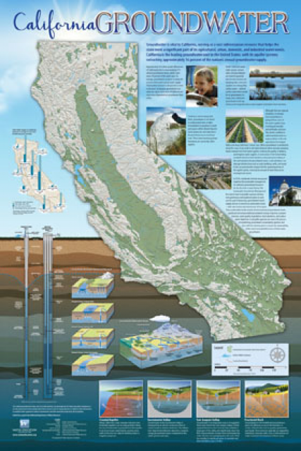
These natural basins that sit below the surface are found underneath 40 percent of California’s land area.

Aquifers come in two types. Some are formed in the space between porous materials such as sand, gravel, silt or clay and are known as alluvial aquifers (sediments deposited by flowing water) or unconfined aquifers. However, in many places across California, there are aquifers beneath a rock layer that does not allow water to permeate in measurable amounts. These are known as confined aquifers.

Confined aquifers that are under pressure are known as artesian aquifers. This pressure can push water to the surface, which when drilled are called artesian wells.  Aquifers can also be several feet deep or several thousand feet deep and can be found across California, from the brackish coast to the Central Valley to the desert interior.

This diverse geography brings with it a range of challenges. Adding to those challenges, California uses more groundwater — the main water source for aquifers — than can be replaced naturally or artificially.

Aquifers Overview

Aquifers play an important role as a source of freshwater for urban areas and agricultural irrigation. Unlike surface water, which is mostly found in the northern and eastern parts of the state, aquifers are widely distributed throughout California. Additionally, they are also often found in places where freshwater is most needed, for instance, in the Central Valley and Los Angeles.

Similar to a below-ground sponge, aquifers are the natural accumulation of runoff and precipitation. Below the surface, this runoff then percolates into crevices between rocks, silt and other material.

Generally, water purveyors prefer to tap aquifers closest to the surface because it is more practical and cheaper to pump. Alluvial aquifers, confined by looser material, are also favorable sources of groundwater rather than the tougher confined aquifers. However, some confined aquifers, if drilled, can contain enough pressure to drive water to the surface without a pump. 

Overall, aquifers — as a subsurface natural reservoir — also help meet California’s increasing demand for groundwater. About 40 percent of the state’s water needs are met by groundwater in normal years and as much as 60 percent during a drought. Groundwater dependence varies, from as little as 5 percent in the San Francisco Bay Area to 83 percent in the Central Coast region. Water officials also view depleted aquifers as good places to store water for use in the future, a process known as groundwater banking.

As California’s population continues to grow, new challenges confront aquifer use as the state tries to balance groundwater sustainability with demand for water.

Aquifer Challenges

Surging demand for water, and such related practices as overdrafting, have burdened aquifers and connected ecosystems in recent decades. In 2014, California’s Sustainable Groundwater Management Act was enacted, requiring governments and water agencies to halt overdraft and bring the most affected groundwater basins into balanced levels of pumping and recharge.

In consequence, depleted aquifers are vulnerable to both natural and man-made contamination.

With nature, elements such as radon and arsenic can leach into aquifers that have been drawn down. Meanwhile, lowered levels of freshwater in the top layers of aquifers can also expose heavier salt water sitting at the bottom, degrading water quality. At the same time, along the coast, particularly in the highly agricultural Pajaro and Salinas valleys of Central California, seawater can also intrude into depleted aquifers.

Similarly, in some cases, salty groundwater can come from ancient seawater that was isolated in the subsurface sediments until pumping began. The northern San Joaquin Valley near Stockton has problems with pockets of seawater that are drawn via pumps into the freshwater aquifers. In the northern Sacramento Valley, some pumpers are at risk of tapping into ancient deposits of sea water, which can degrade the quality of the groundwater.

Man-made pollutants, once thought to be filtered out by the soil, are now known to harm water quality as well. These contaminants include industrial solvents and pesticides.

In some cases, the challenges to aquifer sustainability are being addressed by recharging aquifers with surface water (rather than waiting for them to refill naturally) through a process called conjunctive use.

In other situations, proper management of aquifers is still in development, particularly as courts have established that groundwater may be pumped and used on land far from the original source.

  • Print-friendly

Referring Pages

Share this page

  • Share on Facebook
  • Share on Twitter
  • Share on LinkedIn
  • Sent to a friend.
Print-friendly

Related Links

Aquapedia background January 30, 2014
Back
This item appears in:
  • A
Footer pod May 20, 2014

Water Education Foundation

Copyright © 2023 Water Education Foundation. All rights reserved.

The Water Education Foundation is a nonprofit, tax-exempt, 501(c)3 organization, federal tax ID #942419885.

Privacy Policy

Donor Privacy Policy

  • Read more
Footer pod May 20, 2014

Contact Information

2151 River Plaza Drive, Suite 205
Sacramento CA 95833

Telephone (916) 444-6240

Contact Us via email

  • Read more

Quicklinks

Footer quicklink May 20, 2014

Contact Us

  • Read more
Footer quicklink May 20, 2014

Donate Today

  • Read more
Footer quicklink May 20, 2014

Tours

  • Read more
Footer quicklink May 20, 2014

Newsletter Signup

  • Read more
Footer quicklink May 20, 2014

Foundation News

  • Read more
Footer quicklink May 20, 2014

Calendar

  • Read more

Log in

  • Create new account
  • Request new password

Commands

  • Support portal
  • Log in