Header link June 22, 2020

LinkedIn

  • Read more
Header link September 15, 2014

Cart

  • Read more
Header link November 3, 2015

Donate Now

  • Read more
Header link May 15, 2014

Twitter

  • Read more
Header link May 15, 2014

Facebook

  • Read more
Instagram
Header link May 15, 2014

Instagram

  • Read more
Header link May 15, 2014

Contact Us

  • Read more
More options
Water Education Foundation
Home

Water Education Foundation

Everything about California water that matters
  • Water Academy
    • Agriculture
      • Agricultural Conservation
      • Agricultural Drainage
    • Background Information
      • Legislation — California and Federal
      • Regulations — California and Federal
      • Water History
      • Water Rights
    • Bay-Delta
      • Bay Delta
      • Bay Delta Conservation Plan
      • Delta Issues
      • Delta Smelt
      • Sacramento San Joaquin Delta
      • San Francisco Bay
      • Suisun Marsh
    • Dams, Reservoirs and Water Projects
      • California Aqueduct
      • Central Valley Project
      • Folsom Dam
      • Friant Dam
      • Hetch Hetchy
      • Hoover Dam
      • Infrastructure
      • Lake Mead
      • Lake Powell
      • Oroville Dam
      • San Luis Dam
      • Shasta Dam
      • State Water Project
    • Environmental Issues
      • Anadromous Fish Restoration
      • Ecosystem
      • Endangered Species Act
      • Invasive species
      • Lake Tahoe
      • Mono Lake
      • Public Trust Doctrine
      • Salmon
      • San Joaquin River Restoration
      • Watershed
      • Wetlands
    • Leaders and Experts
    • Regions
      • Central Coast
      • Central Valley
      • Mexico
      • Nevada
      • North Coast
      • Pyramid Lake
      • Sacramento Valley
      • Salton Sea
      • San Joaquin Valley
      • Sierra Nevada
      • Southern California
      • Tulare Lake Basin
    • Rivers
      • Carson River
      • Colorado River
      • Klamath River
      • New River
      • North Coast Rivers
      • Russian River
      • Sacramento River
      • Truckee River
      • San Joaquin River
    • Water Issues
      • Climate Change
      • Coronavirus
      • Drought
      • Earthquakes
      • Energy and Water
      • Floods
      • Fracking
      • Growth
      • Hydropower
      • Levees
      • Tribal Water Issues
      • Water Conservation
    • Water Quality
      • Drinking Water
      • Nitrate contamination
      • Pollution
      • Stormwater
      • Wastewater
      • Water Quality
    • Water Supply and Management
      • Acre Foot
      • Aquifers
      • California Water Plan
      • Conjunctive Use
      • Desalination
      • Grey water
      • Groundwater
      • Integrated Regional Water Management
      • Recreation
      • Surface Water
      • Water Marketing and Banking
      • Water Rates
      • Water Recycling
      • Water Supply
      • Water Transfers
  • Tours & Events
    • Water Tours
      • 2024 Tour Sponsors
    • Events
    • Event Calendar
    • Past Tours & Events
      • Anne J. Schneider Fund Lecture Series
  • Specialized Programs
    • Water Leaders
      • Cohort Rosters
      • Yearly Class Reports
      • Your Alumni Network
      • Alumni Profiles
    • Project WET
      • Workshops
      • Special Workshops & Events
      • Supplementary Materials
      • California Content Standard Correlations
      • Facilitator's Trainings
      • Foundation School Programs
        • Elementary Programs
        • Secondary Programs
      • Water Kids
      • California Project WET Gazette
      • Gazette Archives
    • Colorado River Project
    • GRA Scholastic Fund Program
  • Maps & Guides
    • Maps & Posters
    • Layperson's Guides
    • Map & Guide Bundles
    • Books
    • Colorado River Materials
    • California Runoff Rundown
    • Other Publications
    • Water Awareness Materials
    • Downloadable Publications
    • Videos and DVDs
      • Video Clips
    • School Age Publications
    • Stickers
    • Free Programs and Publications
  • Newsroom
    • Western Water News
    • Aquafornia
      • About Aquafornia
    • Information Desk
    • Western Water Magazine Archive
      • Full Print Edition
      • Print Edition Excerpts
    • River Report Archive
  • Aquapedia
    • Alphabetical List of Subjects
      • A
      • B
      • C
      • D
      • E
      • F
      • G
      • H
      • I
      • J
      • K
      • L
      • M
      • N
      • O
      • P
      • Q
      • R
      • S
      • T
      • U
      • V
      • W
      • X
      • Y
      • Z
    • Historical Water People
    • Where Does My Water Come From?
      • Northern California
      • Sacramento
      • North Bay
      • South Bay
      • Central Valley
      • Los Angeles
      • Inland Empire
      • San Diego
      • All California Water Sources
    • Timelines
    • Videos
    • Image Gallery
    • Water Directory
      • Federal Agencies
      • State Agencies in California
      • Environmental Organizations
      • Other California Organizations
      • State and Federal Legislative Committees
      • Water Associations and Groups
      • Western States Water Agencies and Districts
    • Online Resources
    • Useful Acronyms
    • About Aquapedia
  • About
    • About Us
      • Board of Directors
      • Staff Biographies
      • Job Openings
    • Announcements
    • Support Our Mission
      • Become a Member
      • Donate in Honor/Memory
      • Planned Giving
    • Contact Us
Aquapedia background February 11, 2014 Dams Layperson's Guide to the Central Valley Project Layperson's Guide to the State Water Project

San Luis Reservoir

Aerial view of San Luis Reservoir

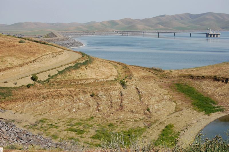
The San Luis Reservoir is the nation’s largest off-stream reservoir, serving as a key water facility for both the State Water Project (SWP) and the federal Central Valley Project (CVP).

Impounded by the 382-foot-high, 3-mile long B.F. Sisk Dam, the reservoir 12 miles west of Los Banos can hold 2 million acre-feet of water. The federal Bureau of Reclamation built the dam and the California Department of Water Resources operates it. The state’s share of the reservoir water is about 55 percent.

Authorized in 1960 as part of the federal San Luis Unit project, the reservoir began operating in 1969, providing a variety of recreational activities and benefits to ish and wildlife.

The reservoir stores water that has traveled south from the Sacramento-San Joaquin Delta to the O’Neill Forebay via the California Aqueduct and CVP’s Delta-Mendota Canal.

The San Luis Canal, the federally built section of the California Aqueduct, starts at the forebay and runs 102 miles south to Kettleman City in Kings County. There, it connects with the state-built southern portion of the California Aqueduct, continuing to Southern California.

San Luis Reservoir provides additional flexibility to the state and federal water delivery systems by allowing for storage of excess winter and spring flows diverted from the Delta until the water is needed later in the year by SWP and CVP contractors.

About 30 percent of SWP water is delivered to San Joaquin Valley farms and cities via the California Aqueduct. The largest single customer in this area is the Kern County Water Agency, which buys up to 1 million acre-feet of water a year. Just south of Kettleman City, the Coastal Branch diverges from the main aqueduct to deliver water to Kern, Santa Barbara and San Luis Obispo counties.

San Luis Reservoir provides flexibility for both water projects. For instance, during periods of high runoff, usually in winter and spring, SWP operators pump water into storage at the reservoir for use during drier periods or may release water from Northern California’s Lake Oroville to make room for anticipated flood flows. Likewise, Reclamation stores excess water in San Luis for later use by farms, cities and wildlife refuges.

In 2023, the Department of the Interior and San Luis & Delta-Mendota Water Authority approved plans to raise Sisk Dam by 10 feet to create 130,000 acre-feet of additional water storage. The additional space created in San Luis Reservoir will be used to store water for delivery to south-of-Delta water contractors and wildlife refuges. The water will be used to meet existing contractual obligations and not serve any new demands.

An accompanying dam safety project is also underway to protect Sisk Dam from future earthquakes. Reclamation is adding stability berms and other safety features to the dam, which was built on an active fault.

In November 2024, the Interior Department’s Bureau of Reclamation announced it had completed its negotiations with the Water Authority on the dam-raising project. The $1 billion expansion is expected to be completed by 2032.

Updated November 2024

  • Print-friendly

Referring Pages

Share this page

  • Share on Facebook
  • Share on Twitter
  • Share on LinkedIn
  • Sent to a friend.
Print-friendly

Related Links

Aquapedia background February 11, 2014 Dams Layperson's Guide to the Central Valley Project Layperson's Guide to the State Water Project
Folsom Dam on the American River east of Sacramento
Aquapedia background February 3, 2014 Layperson's Guide to the Central Valley Project Layperson's Guide to the State Water Project Oroville Dam Shasta Dam Hoover Dam

Dams

Dams have allowed Californians and others across the West to harness and control water dating back to pre-European settlement days when Native Americans had erected simple dams for catching salmon.

  • Read more
Publication May 20, 2014

Layperson’s Guide to the Central Valley Project
Updated 2021

The 24-page Layperson’s Guide to the Central Valley Project explores the history and development of the federal Central Valley Project (CVP), California’s largest surface water delivery system. In addition to the project’s history, the guide describes the various facilities, operations and benefits the water project brings to the state along with the CVP Improvement Act (CVPIA).

  • Read more
Publication May 20, 2014

Layperson’s Guide to the State Water Project
Updated 2013

The 24-page Layperson’s Guide to the State Water Project provides an overview of the California-funded and constructed State Water Project.

The State Water Project is best known for the 444-mile-long aqueduct that provides water from the Delta to San Joaquin Valley agriculture and southern California cities. The guide contains information about the project’s history and facilities.

  • Read more
Back
This item appears in:
  • Topic: Sacramento San Joaquin Delta
  • Topic: San Luis Dam
  • Topic: Water Supply
  • S
Footer pod May 20, 2014

Water Education Foundation

Copyright © 2025 Water Education Foundation. All rights reserved.

The Water Education Foundation is a nonprofit, tax-exempt, 501(c)3 organization, federal tax ID #942419885.

Privacy Policy

Donor Privacy Policy

  • Read more
Footer pod May 20, 2014

Contact Information

2151 River Plaza Drive, Suite 205
Sacramento CA 95833

Telephone (916) 444-6240

Contact Us via email

  • Read more

Quicklinks

Footer quicklink May 20, 2014

Contact Us

  • Read more
Footer quicklink May 20, 2014

Donate Today

  • Read more
Footer quicklink May 20, 2014

Tours

  • Read more
Footer quicklink May 20, 2014

Newsletter Signup

  • Read more
Footer quicklink May 20, 2014

Foundation News

  • Read more
Footer quicklink May 20, 2014

Calendar

  • Read more

Log in

  • Create new account
  • Request new password

Commands

  • Support portal
  • Log in