Header link June 22, 2020

LinkedIn

  • Read more
Header link September 15, 2014

Cart

  • Read more
Header link November 3, 2015

Donate Now

  • Read more
Header link May 15, 2014

Twitter

  • Read more
Header link May 15, 2014

Facebook

  • Read more
Instagram
Header link May 15, 2014

Instagram

  • Read more
Header link May 15, 2014

Contact Us

  • Read more
More options
Water Education Foundation
Home

Water Education Foundation

Everything about California water that matters
  • Water Academy
    • Agriculture
      • Agricultural Conservation
      • Agricultural Drainage
    • Background Information
      • Legislation — California and Federal
      • Regulations — California and Federal
      • Water History
      • Water Rights
    • Bay-Delta
      • Bay Delta
      • Bay Delta Conservation Plan
      • Delta Issues
      • Delta Smelt
      • Sacramento San Joaquin Delta
      • San Francisco Bay
      • Suisun Marsh
    • Dams, Reservoirs and Water Projects
      • California Aqueduct
      • Central Valley Project
      • Folsom Dam
      • Friant Dam
      • Hetch Hetchy
      • Hoover Dam
      • Infrastructure
      • Lake Mead
      • Lake Powell
      • Oroville Dam
      • San Luis Dam
      • Shasta Dam
      • State Water Project
    • Environmental Issues
      • Anadromous Fish Restoration
      • Ecosystem
      • Endangered Species Act
      • Invasive species
      • Lake Tahoe
      • Mono Lake
      • Public Trust Doctrine
      • Salmon
      • San Joaquin River Restoration
      • Watershed
      • Wetlands
    • Leaders and Experts
    • Regions
      • Central Coast
      • Central Valley
      • Mexico
      • Nevada
      • North Coast
      • Pyramid Lake
      • Sacramento Valley
      • Salton Sea
      • San Joaquin Valley
      • Sierra Nevada
      • Southern California
      • Tulare Lake Basin
    • Rivers
      • Carson River
      • Colorado River
      • Klamath River
      • New River
      • North Coast Rivers
      • Russian River
      • Sacramento River
      • Truckee River
      • San Joaquin River
    • Water Issues
      • Climate Change
      • Coronavirus
      • Drought
      • Earthquakes
      • Energy and Water
      • Floods
      • Fracking
      • Growth
      • Hydropower
      • Levees
      • Tribal Water Issues
      • Water Conservation
    • Water Quality
      • Drinking Water
      • Nitrate contamination
      • Pollution
      • Stormwater
      • Wastewater
      • Water Quality
    • Water Supply and Management
      • Acre Foot
      • Aquifers
      • California Water Plan
      • Conjunctive Use
      • Desalination
      • Grey water
      • Groundwater
      • Integrated Regional Water Management
      • Recreation
      • Surface Water
      • Water Marketing and Banking
      • Water Rates
      • Water Recycling
      • Water Supply
      • Water Transfers
  • Tours & Events
    • Water Tours
      • 2025 Tour Sponsors
    • Events
    • Event Calendar
    • Past Tours & Events
      • Anne J. Schneider Fund Lecture Series
  • Specialized Programs
    • Water Leaders
      • Cohort Rosters
      • Yearly Class Reports
      • Your Alumni Network
      • Alumni Profiles
    • Project WET
      • Workshops
      • Supplementary Materials
      • California Content Standard Correlations
      • Foundation School Programs
        • Elementary Programs
        • Secondary Programs
      • Water Kids
      • California Project WET Gazette
      • Gazette Archives
    • Colorado River Project
    • GRA Scholastic Fund Program
  • Maps & Guides
    • Maps & Posters
    • Layperson's Guides
    • Map & Guide Bundles
    • Books
    • Colorado River Materials
    • California Runoff Rundown
    • Other Publications
    • Water Awareness Materials
    • Downloadable Publications
    • Videos and DVDs
      • Video Clips
    • School Age Publications
    • Stickers
    • Free Programs and Publications
  • Newsroom
    • Western Water News
    • Aquafornia
      • About Aquafornia
    • Information Desk
    • Western Water Magazine Archive
      • Full Print Edition
      • Print Edition Excerpts
    • River Report Archive
  • Aquapedia
    • Alphabetical List of Subjects
      • A
      • B
      • C
      • D
      • E
      • F
      • G
      • H
      • I
      • J
      • K
      • L
      • M
      • N
      • O
      • P
      • Q
      • R
      • S
      • T
      • U
      • V
      • W
      • X
      • Y
      • Z
    • Historical Water People
    • Where Does My Water Come From?
      • Northern California
      • Sacramento
      • North Bay
      • South Bay
      • Central Valley
      • Los Angeles
      • Inland Empire
      • San Diego
      • All California Water Sources
    • Timelines
    • Videos
    • Image Gallery
    • Water Directory
      • Federal Agencies
      • State Agencies in California
      • Environmental Organizations
      • Other California Organizations
      • State and Federal Legislative Committees
      • Water Associations and Groups
      • Western States Water Agencies and Districts
    • Online Resources
    • Useful Acronyms
    • About Aquapedia
  • About
    • About Us
      • Board of Directors
      • Staff Biographies
      • Job Openings
    • Announcements
    • Support Our Mission
      • Become a Member
      • Donate in Honor/Memory
      • Planned Giving
    • Contact Us
Aquapedia background February 11, 2014 The Lower Yuba Accord: From Controversy to Consensus How Volunteer ‘Streamkeepers’ Influence Water Policy Across the West SPOTLIGHT: Putah Creek, Yuba River and environmental water for fish

Yuba River and Yuba Accord

Lower Yuba RiverThe Yuba River is a major tributary to the Feather River and the larger Sacramento River watershed with an average annual runoff of about 2.4 million acre-feet. The river originates high in the snow-capped Sierra Nevada and flows through granitic canyons and rolling foothills before joining the Feather River at Yuba City. The river is an important source of hydroelectric power, water supply for Sacramento Valley farms and a spawning ground for salmon. It is also notoriously flood-prone, with at least 10 significant floods since California statehood in 1850.

BACKGROUND

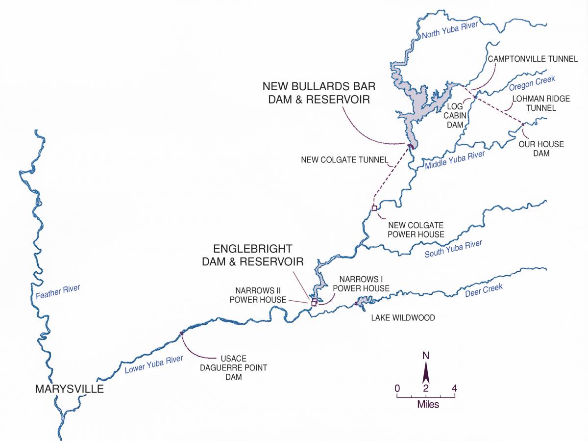
The Yuba River is the fourth-largest river in the Sacramento River watershed. The Yuba River is comprised of three river forks cutting their way down through the northern Sierra Nevada. The North Fork begins near the eastern border of Tahoe National Forest; the Middle Fork starts in Moscove Meadow; and the South Fork originates near Donner Pass. A portion of the South Fork is listed as a state Wild and Scenic River.

Native American tribes lived in the watershed and made use of its resources before the discovery of gold in 1848. The gold discovery drew thousands of miners to the Yuba River watershed and many soon started digging ditches to divert water from the river for their mining operations. Eventually, large-scale hydraulic mining took hold, blasting the hillsides with pressurized streams of water to unearth the gold. Much of the resulting mud and rocks filled downstream river channels, raising water levels and flooding farms and communities. Legal challenges finally ended hydraulic mining, but the flood risk remained.

As farming eclipsed mining, the Yuba River began being dammed in the late 1800s and early 1900s for agricultural irrigation and hydroelectricity. Some of California’s earliest hydroelectric power plants were developed in the 1,339-square-mile Yuba River watershed.

Even with dams upstream, dangerous flooding downstream remained a threat. In 1955 the Yuba River came within feet of flooding Marysville, forcing 30,000 people to evacuate. Forty people lost their lives. Then in 1986, a section of levee along the Yuba River near Marysville gave way, flooding about 30 square miles and forcing more than 26,000 people to evacuate.

Mining’s legacy has continued to be felt long after the last hydraulic nozzle shut down. Mercury from hydraulic mining is present in streambeds and reservoirs. In 1941, the Army Corps of Engineers completed Englebright Dam to capture debris from hydraulic mining that threatened to cause downstream flooding. New Bullards Bar Dam, California’s second-tallest dam at 645-feet-tall, was completed in 1970 on the North Yuba River in part to improve flood control.

CHALLENGES AND CONTROVERSIES

New Bullards Bar Dam was built by the Yuba County Water Agency (later renamed Yuba Water Agency) to generate hydropower and provide water to local growers in addition to improving flood control. However, it also put native chinook salmon and steelhead at risk.

Yuba River mapIn response, environmental groups started filing lawsuits in the 1980s. The Yuba Water Agency and its water users, along with state and federal water agencies, reached a landmark multi-agency agreement known as the Lower Yuba River Accord. It took effect in 2008 after two years as a pilot project.

The Yuba Accord balances the interests of environmental groups, agriculture, water agencies and hydroelectric operators relying on water from the Yuba River.

Pieced together after two decades of lawsuits, the Yuba Accord allows for freshwater flows to support native fish while also providing water for hydropower, transfers and irrigation.

The accord has three separate but related agreements:

The Fisheries Agreement set significantly higher minimum instream flow requirements during certain times of the year to benefit wild fish in the lower Yuba, the 24-mile stretch between Englebright Dam and the Feather River near Marysville.

The Water Purchases Agreement established a long-term water transfer program in which Yuba Water Agency sells water it already released from New Bullards Bar Reservoir for the benefit of fish to others in the state who need it. The agency must also release 60,000 acre-feet annually for the Sacramento-San Joaquin Delta. Water transfers are capped at 200,000 acre-feet a year.

The Conjunctive Use Agreements provide groundwater for irrigating local farmland during dry years to ensure the Yuba River has enough water to sustain fish.

In 2026, the State Water Resources Control Board approved extension of the Yuba Accord’s water transfer program until 2050.

LOOKING AHEAD

Improving habitat and access for threatened fish and reducing downstream flood risk remain ongoing concerns.

A collaborative effort launched in 2025 among local, state and federal agencies is aimed at improving habitat and access to upstream spawning grounds for salmon and other threatened fish that are impeded by Daguerre Point Dam, an Army Corps of Engineers dam on the lower Yuba River 10 miles east of Marysville. 

Climate change is expected to bring more extended droughts and more intense storms with huge amounts of rain, a worry in a flood-prone watershed like the Yuba River. At New Bullards Bar Dam, Yuba Water Agency has changed its reservoir practices to incorporate weather forecasts in its winter flood-management decisions rather than rely on static flood-management rules. The agency also is constructing a lower, secondary spillway to enhance its flexibility to release water sooner when extreme storms approach.

Updated June 2026

  • Print-friendly

Referring Pages

Share this page

  • Share on Facebook
  • Share on Twitter
  • Share on LinkedIn
  • Sent to a friend.
Print-friendly

Related Links

Aquapedia background February 11, 2014 The Lower Yuba Accord: From Controversy to Consensus How Volunteer ‘Streamkeepers’ Influence Water Policy Across the West SPOTLIGHT: Putah Creek, Yuba River and environmental water for fish
Publication August 18, 2014

The Lower Yuba Accord: From Controversy to Consensus
Published 2009

This 24-page booklet details the conflict between environmentalists, fish organizations and the Yuba County Water Agency and how it was resolved through the Lower Yuba River Accord – a unique agreement supported by 18 agencies and non-governmental organizations. The publication details the history and hydrology of the Yuba River, past and present environmental concerns, and conflicts over dam operations and protecting endangered fish is included.

  • Read more
Western Water February 29, 2024 California Water Map Western Water News: How Volunteer ‘streamkeepers’ influence water policy across the West Nick Cahill

How Volunteer ‘Streamkeepers’ Influence Water Policy Across the West
WESTERN WATER NOTEBOOK: Meticulous Data Collection, Local Expertise Aid Environmental Regulators

Water sampling on South Yuba RiverWhen residents of the Yuba River watershed northeast of Sacramento saw a stretch of the emerald-green river suddenly turn an alarming reddish-brown on a recent winter day, they knew immediately who to call.

Though water quality concerns are the purview of federal, state and county environmental agencies, they alerted the local South Yuba River Citizens League, confident its volunteers could get to the scene quicker and investigate the discoloration faster than any regulator.

  • Read more
Western Water February 23, 2018 Gary Pitzer

SPOTLIGHT: Putah Creek, Yuba River and environmental water for fish
Two legal settlements are cited as examples where water was set aside for environmental needs

Lower Yuba RiverDespite the heat that often accompanies debates over setting aside water for the environment, there are instances where California stakeholders have forged agreements to provide guaranteed water for fish. Here are two examples cited by the Public Policy Institute of California in its report arguing for an environmental water right.

  • Read more
Back
This item appears in:
  • Topic: Hydropower
  • Topic: Water Transfers
  • Y
Footer pod May 20, 2014

Water Education Foundation

Copyright © 2026 Water Education Foundation. All rights reserved.

The Water Education Foundation is a nonprofit, tax-exempt, 501(c)3 organization, federal tax ID #942419885.

Privacy Policy

Donor Privacy Policy

  • Read more
Footer pod May 20, 2014

Contact Information

2151 River Plaza Drive, Suite 205
Sacramento CA 95833

Telephone (916) 444-6240

Contact Us via email

  • Read more

Quicklinks

Footer quicklink May 20, 2014

Contact Us

  • Read more
Footer quicklink May 20, 2014

Donate Today

  • Read more
Footer quicklink May 20, 2014

Tours

  • Read more
Footer quicklink May 20, 2014

Newsletter Signup

  • Read more
Footer quicklink May 20, 2014

Foundation News

  • Read more
Footer quicklink May 20, 2014

Calendar

  • Read more

Log in

  • Create new account
  • Request new password

Commands

  • Support portal
  • Log in