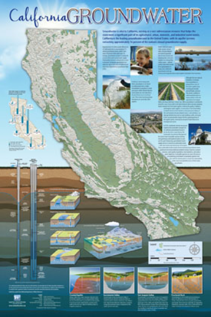
High-Tech Mapping of Central Valley’s Underground Blazes Path to Drought Resilience
WESTERN WATER NOTEBOOK: Aerial Surveillance Reveals Best Spots to Store Floodwater for Dry Times but Delivering the Surplus Remains Thorny
") A new underground mapping technology
that reveals the best spots for storing surplus water in
California’s Central Valley is providing a big boost to the
state’s most groundwater-dependent communities.
A new underground mapping technology
that reveals the best spots for storing surplus water in
California’s Central Valley is providing a big boost to the
state’s most groundwater-dependent communities.
The maps provided by the California Department of Water Resources for the first time pinpoint paleo valleys and similar prime underground storage zones traditionally found with some guesswork by drilling exploratory wells and other more time-consuming manual methods. The new maps are drawn from data on the composition of underlying rock and soil gathered by low-flying helicopters towing giant magnets.
The unique peeks below ground are saving water agencies’ resources and allowing them to accurately devise ways to capture water from extreme storms and soak or inject the surplus underground for use during the next drought.
“Understanding where you’re putting and taking water from really helps, versus trying to make multimillion-dollar decisions based on a thumb and which way the wind is blowing,” said Aaron Fukuda, general manager of the Tulare Irrigation District, an early adopter of the airborne electromagnetic or AEM technology in California.
“AEM is making the invisible visible, but it’s not a panacea,” said Graham Fogg, a professor emeritus of hydrogeology at UC Davis
State and local water managers are already putting the maps to work in the flooded Tulare Lake Basin and elsewhere, funneling some of the flows into areas tagged by the aerial surveys as having the right underground composition for swiftly absorbing runoff.
Peeling back the layers of Central Valley aquifers, AEM technology could help local water managers execute state-required groundwater sustainability plans for their basins. But knowing the best areas to deposit surplus water underground is just a start: Local agencies still must buy land, build recharge basins, add infrastructure to pump and deliver the water, and in some cases acquire new water rights.
“AEM is making the invisible visible, but it’s not a panacea,” said Graham Fogg, a professor emeritus of hydrogeology at the University of California, Davis. “But I regard it as an important catalyst.”
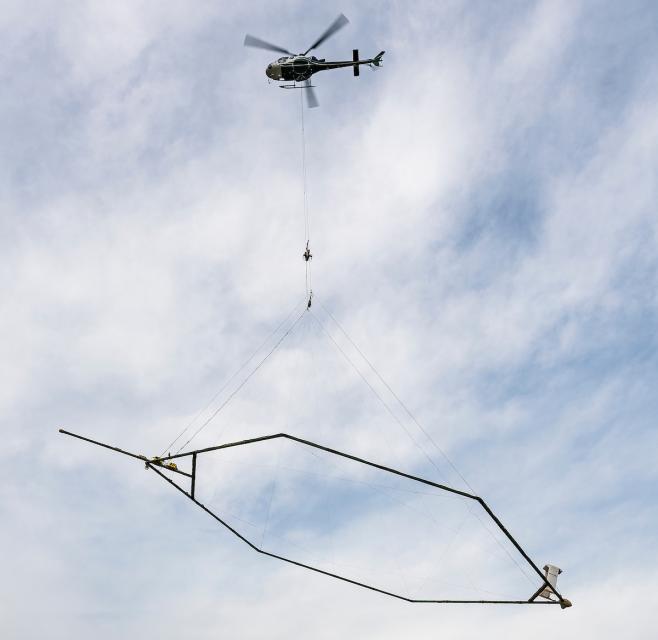
Helicopters Map the Underground
Boosting depleted aquifers is especially important in the agricultural-rich San Joaquin Valley, where some researchers have pegged the region’s annual groundwater deficit at about 2 million acre-feet, enough to supply 4 to 6 million households for a year.
In dry years, farms and cities often receive less surface water and dip into their groundwater savings accounts. California’s overreliance on groundwater has led to overpumping – mining groundwater faster than it is replenished.
") Overpumping has caused water tables
to decline, lands to sink or subside, and depleted some wells,
leaving some communities without clean sources of drinking water.
In response, California lawmakers in 2014 passed the landmark
Sustainable Groundwater Management Act that for the first
time regulated groundwater use statewide. Local agencies in the
most critically overpumped basins must achieve their
sustainability goals by 2040.
Overpumping has caused water tables
to decline, lands to sink or subside, and depleted some wells,
leaving some communities without clean sources of drinking water.
In response, California lawmakers in 2014 passed the landmark
Sustainable Groundwater Management Act that for the first
time regulated groundwater use statewide. Local agencies in the
most critically overpumped basins must achieve their
sustainability goals by 2040.
Beginning in early 2021, the state directed the helicopter reconnaissance flights over depleted groundwater basins in search of underground sponge-like channels called paleo valleys where surface water can quickly percolate and refill aquifers.
The surveillance is intended to fill in data gaps and help local agencies comply with the state’s groundwater law. The helicopters have surveyed more than 11,000 miles across the Central Valley, Salinas Valley, Monterey Bay and parts of Northern California.
The mapping technique is like magnetic resonance imaging (MRI), which uses a magnetic field and computer-generated radio waves to create detailed images of bodily organs and tissues.
The magnets in giant hexagon-shaped frames suspended from helicopters send an electromagnetic signal into the ground and a return signal bounces back, revealing the type of materials in the subsurface. Gravel, sand and other coarse grains known to promote the flow of water produce a distinctly different signal than those from the far less permeable clays and silt. The return signals are recorded and used to assemble color-coded 3-D maps that cover depths of around 1,000 feet.
Katherine Dlubac, who manages the state’s surveillance project, said the maps are giving remarkably detailed snapshots of aquifers that will help groundwater managers prepare for California’s extremely variable weather.
“The [AEM data] is really going to help us forgo drought and flood emergencies and make us think about the most efficient ways to get water back into aquifers,” Dlubac said.
") To complement the airborne surveys,
the state or local agencies often comb over areas of interest
again with all-terrain vehicles equipped with similar technology
known as the transient electromagnetic method. This provides an
even higher-resolution picture of the underground and can also
help identify areas susceptible to subsidence.
To complement the airborne surveys,
the state or local agencies often comb over areas of interest
again with all-terrain vehicles equipped with similar technology
known as the transient electromagnetic method. This provides an
even higher-resolution picture of the underground and can also
help identify areas susceptible to subsidence.
The Department of Water Resources released the full set of Central Valley maps in February and expects to have the 3-D diagrams of the state’s lower-priority groundwater basins available in 2024.
The agency hired two Denmark-based companies, Ramboll and SkyTEM, to interpret and process the data. The $12 million program is funded partly through Proposition 68, a $4 billion bond voters approved in 2018 for water infrastructure projects, flood protection and other uses.
Aerial mapping of groundwater basins has been done in Nebraska, Denmark, Australia and other countries. The catalyst for California was a groundbreaking study showing AEM could detect the subterranean paleo valleys that can absorb as much as 60 percent more water than the clay areas that dominate the San Joaquin Valley, according to Fogg, who co-authored the study led by Stanford geophysicist Rosemary Knight.
Fogg helped discover a paleo valley in the Kings River watershed in Fresno County decades ago through borehole data and soil samples. He and Knight wanted to see if there was an easier way to find these zones. Their study proved that AEM mapping from above ground could help unlock other recharge zones hidden below.
Putting the Data to Work
Aquifer mapping has been a boon to resource-strapped local agencies trying to comply with the state groundwater law and rectify their longstanding groundwater imbalances.
“AEM is literally helping us identify the needle in the haystack.” ~Kassy Chauhan, executive director of the North Kings Groundwater Sustainability Agency
Before AEM, many important groundwater management decisions were primarily based on data from well logs that can be inaccurate or become outdated. Some San Joaquin Valley water managers contend the AEM data is fundamentally changing how they decide where to build expensive recharge basins or restrict pumping.
For example, Fukuda said the AEM data revealed that the aquifers on the eastern edge of the Kaweah Subbasin, which covers Visalia and parts of Tulare County, were shallower than originally thought. The data also showed that there was more recharge potential on the western side of the basin.
As a result, Fukuda said groundwater pumping is limited or more closely monitored on the east while new recharge projects have been built or planned for the western side. In the neighboring Kings Subbasin, water managers are looking to take advantage of a paleo valley northeast of Fresno discovered in the aerial surveillance data.
“AEM is literally helping us identify the needle in the haystack,” said Kassy Chauhan, executive director of the North Kings Groundwater Sustainability Agency.
Local and state groundwater managers said AEM data helped this spring in determining the best areas to spread floodwater from the winter storms and Sierra snowmelt.
Recharge Hurdles Remain
The ultimate success of the AEM program depends on local water managers getting the land, the money and the permits to divert floodwater into depleted aquifers.
") Finding willing sellers and convincing
elected officials or ratepayers to approve deals can be thorny
and protracted, let alone securing funds to build recharge
basins, wells, pumps and canals to deliver the banked water to
communities and farmland that could be miles away.
Finding willing sellers and convincing
elected officials or ratepayers to approve deals can be thorny
and protracted, let alone securing funds to build recharge
basins, wells, pumps and canals to deliver the banked water to
communities and farmland that could be miles away.
“On a statewide level, we’ve got to get more infrastructure in place to move [flood] water,” Fukuda said.
UC Davis’ Fogg pointed to a situation in Sacramento County where local agencies have the infrastructure and water supply needed to spread American River water over paleo valleys discovered in 2017. However, the prime recharge sites that extend from the American River southeast to the Cosumnes River, are slated for major housing and commercial developments and local officials don’t seem likely to intervene, Fogg said.
Though the State Water Resources Control Board is trying to streamline the process for diverting flood flows – and Gov. Gavin Newsom temporarily suspended regulations this year to boost recharge – the state’s water rights system still makes it tough for agencies to take water from streams already fully appropriated, as is the case for many Central Valley waterways, Fogg said.
AEM technology is giving California water managers an up-close view of their aquifers and accelerating the planning process for recharge projects. The blueprints are available and there is plenty of space to store the water underground – at least three times more additional water than California’s existing surface reservoirs. Now, water managers must figure out how to leverage the underground maps, fill the state’s massive underground reservoirs and reverse decades of groundwater depletion.
Reach Writer Nick Cahill at ncahill@watereducation.org.
Know someone else who wants to stay connected with water in the West? Encourage them to sign up for Western Water, and follow us on Facebook , Twitter, LinkedIn and Instagram.