Header link June 22, 2020

LinkedIn

  • Read more
Header link September 15, 2014

Cart

  • Read more
Header link November 3, 2015

Donate Now

  • Read more
Header link May 15, 2014

Twitter

  • Read more
Header link May 15, 2014

Facebook

  • Read more
Instagram
Header link May 15, 2014

Instagram

  • Read more
Header link May 15, 2014

Contact Us

  • Read more
More options
Water Education Foundation
Home

Water Education Foundation

Everything about California water that matters
  • Water Academy
    • Agriculture
      • Agricultural Conservation
      • Agricultural Drainage
    • Background Information
      • Legislation — California and Federal
      • Regulations — California and Federal
      • Water History
      • Water Rights
    • Bay-Delta
      • Bay Delta
      • Bay Delta Conservation Plan
      • Delta Issues
      • Delta Smelt
      • Sacramento San Joaquin Delta
      • San Francisco Bay
      • Suisun Marsh
    • Dams, Reservoirs and Water Projects
      • California Aqueduct
      • Central Valley Project
      • Folsom Dam
      • Friant Dam
      • Hetch Hetchy
      • Hoover Dam
      • Infrastructure
      • Lake Mead
      • Lake Powell
      • Oroville Dam
      • San Luis Dam
      • Shasta Dam
      • State Water Project
    • Environmental Issues
      • Anadromous Fish Restoration
      • Ecosystem
      • Endangered Species Act
      • Invasive species
      • Lake Tahoe
      • Mono Lake
      • Public Trust Doctrine
      • Salmon
      • San Joaquin River Restoration
      • Watershed
      • Wetlands
    • Leaders and Experts
    • Regions
      • Central Coast
      • Central Valley
      • Mexico
      • Nevada
      • North Coast
      • Pyramid Lake
      • Sacramento Valley
      • Salton Sea
      • San Joaquin Valley
      • Sierra Nevada
      • Southern California
      • Tulare Lake Basin
    • Rivers
      • Carson River
      • Colorado River
      • Klamath River
      • New River
      • North Coast Rivers
      • Russian River
      • Sacramento River
      • Truckee River
      • San Joaquin River
    • Water Issues
      • Climate Change
      • Coronavirus
      • Drought
      • Earthquakes
      • Energy and Water
      • Floods
      • Fracking
      • Growth
      • Hydropower
      • Levees
      • Tribal Water Issues
      • Water Conservation
    • Water Quality
      • Drinking Water
      • Nitrate contamination
      • Pollution
      • Stormwater
      • Wastewater
      • Water Quality
    • Water Supply and Management
      • Acre Foot
      • Aquifers
      • California Water Plan
      • Conjunctive Use
      • Desalination
      • Grey water
      • Groundwater
      • Integrated Regional Water Management
      • Recreation
      • Surface Water
      • Water Marketing and Banking
      • Water Rates
      • Water Recycling
      • Water Supply
      • Water Transfers
  • Tours & Events
    • Water Tours
      • 2024 Tour Sponsors
    • Events
    • Event Calendar
    • Past Tours & Events
      • Anne J. Schneider Fund Lecture Series
  • Specialized Programs
    • Water Leaders
      • Cohort Rosters
      • Yearly Class Reports
      • Your Alumni Network
      • Alumni Profiles
    • Project WET
      • Workshops
      • Special Workshops & Events
      • Supplementary Materials
      • California Content Standard Correlations
      • Facilitator's Trainings
      • Foundation School Programs
        • Elementary Programs
        • Secondary Programs
      • Water Kids
      • California Project WET Gazette
      • Gazette Archives
    • Colorado River Project
    • GRA Scholastic Fund Program
  • Maps & Guides
    • Maps & Posters
    • Layperson's Guides
    • Map & Guide Bundles
    • Books
    • Colorado River Materials
    • California Runoff Rundown
    • Other Publications
    • Water Awareness Materials
    • Downloadable Publications
    • Videos and DVDs
      • Video Clips
    • School Age Publications
    • Stickers
    • Free Programs and Publications
  • Newsroom
    • Western Water News
    • Aquafornia
      • About Aquafornia
    • Information Desk
    • Western Water Magazine Archive
      • Full Print Edition
      • Print Edition Excerpts
    • River Report Archive
  • Aquapedia
    • Alphabetical List of Subjects
      • A
      • B
      • C
      • D
      • E
      • F
      • G
      • H
      • I
      • J
      • K
      • L
      • M
      • N
      • O
      • P
      • Q
      • R
      • S
      • T
      • U
      • V
      • W
      • X
      • Y
      • Z
    • Historical Water People
    • Where Does My Water Come From?
      • Northern California
      • Sacramento
      • North Bay
      • South Bay
      • Central Valley
      • Los Angeles
      • Inland Empire
      • San Diego
      • All California Water Sources
    • Timelines
    • Videos
    • Image Gallery
    • Water Directory
      • Federal Agencies
      • State Agencies in California
      • Environmental Organizations
      • Other California Organizations
      • State and Federal Legislative Committees
      • Water Associations and Groups
      • Western States Water Agencies and Districts
    • Online Resources
    • Useful Acronyms
    • About Aquapedia
  • About
    • About Us
      • Board of Directors
      • Staff Biographies
      • Job Openings
    • Announcements
    • Support Our Mission
      • Become a Member
      • Donate in Honor/Memory
      • Planned Giving
    • Contact Us
Maps & Posters May 20, 2014

Klamath River Watershed Map
Published 2011

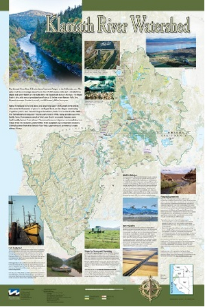
This beautiful 24×36-inch poster, suitable for framing, displays the rivers, lakes and reservoirs, irrigated farmland, urban areas and Indian reservations within the Klamath River Watershed. The map text explains the many issues facing this vast, 15,000-square-mile watershed, including fish restoration; agricultural water use; and wetlands. Also included are descriptions of the separate, but linked, Klamath Basin Restoration Agreement and the Klamath Hydroelectric Agreement, and the next steps associated with those agreements. Development of the map was funded by a grant from the U.S. Fish and Wildlife Service.

To order 10 or more copies at a discounted fee, contact the Foundation at 916-444-6240 for more information.

  • Print-friendly

Referring Pages

Western Water August 3, 2023 Layperson's Guide to the Klamath River Basin Klamath River Watershed Map WESTERN WATER: Solar-Paneled Canopies over Canals Catching on in Southwest By Nick Cahill

‘If You Unbuild It, They Will Come’
WESTERN WATER IN-DEPTH: Scientists Chart Transformation of Klamath River and Its Salmon Amid Nation’s Largest Dam Removal Project

The Copco No. 1 dam on the Klamath RiverThe Klamath River Basin was once one of the world’s most ecologically magnificent regions, a watershed teeming with salmon, migratory birds and wildlife that thrived alongside Native American communities. The river flowed rapidly from its headwaters in southern Oregon’s high deserts into Upper Klamath Lake, collected snowmelt along a narrow gorge through the Cascades, then raced downhill to the California coast in a misty, redwood-lined finish.

  • Read more
Western Water October 19, 2018 Klamath River Watershed Map Layperson's Guide to Groundwater Gary Pitzer

California Leans Heavily on its Groundwater, But Will a Court Decision Tip the Scales Against More Pumping?
WESTERN WATER NOTEBOOK: Pumping near the Scott River in Siskiyou County sparks appellate court ruling extending public trust doctrine to groundwater connected to rivers

Scott River, in Siskiyou County. In 1983, a landmark California Supreme Court ruling extended the public trust doctrine to tributary creeks that feed Mono Lake, which is a navigable water body even though the creeks themselves were not. The ruling marked a dramatic shift in water law and forced Los Angeles to cut back its take of water from those creeks in the Eastern Sierra to preserve the lake.

Now, a state appellate court has for the first time extended that same public trust doctrine to groundwater that feeds a navigable river, in this case the Scott River flowing through a picturesque valley of farms and alfalfa in Siskiyou County in the northern reaches of California.

  • Read more
Aquapedia background February 10, 2014 Layperson's Guide to the Klamath River Basin Klamath River Watershed Map

Klamath River Basin

Cropland around Upper Klamath Lake in Oregon

The Klamath River Basin is one of the West’s most important and contentious watersheds.

The watershed is known for its peculiar geography straddling California and Oregon. Unlike many western rivers, the Klamath does not originate in snowcapped mountains but rather on a volcanic plateau. 

A broad patchwork of spring-fed streams and rivers in south-central Oregon drains into Upper Klamath Lake and down into Lake Ewauna in the city of Klamath Falls. The outflow from Ewauna marks the beginning of the 263-mile Klamath River.

The Klamath courses south through the steep Cascade Range and west along the rugged Siskiyou Mountains to a redwood-lined estuary on the Pacific Ocean just south of Crescent City, draining a watershed of 10 million acres. 

A bounty of resources – water, salmon, timber and minerals – and a wide range of users turned the remote region into a hotspot for economic development and multiparty water disputes (See Klamath River timeline).

Though the basin has only 115,000 residents, there is seldom enough water to go around. Droughts are common. The water scarcity inflames tensions between agricultural, environmental and tribal interests, namely the basin’s four major tribes: the Klamath Tribes, the Karuk, Hoopa Valley and Yurok. Klamath water-use conflicts routinely spill into courtrooms, state legislatures and Congress. 

In 2023, a historic removal of four powers dams on the river began, signaling hope for restoration of the river and its fish and easing tensions between competing water interests. In February 2024, Interior Secretary Deb Haaland announced a “historic” agreement between tribes and farmers in the basin over chronic water shortages. The deal called for a wide range of river and creek restoration work and modernization of agricultural water supply infrastructure. 

Water Development

Farmers and ranchers have drawn irrigation water from basin rivers and lakes since the late 1900s. Vast wetlands around Upper Klamath Lake and upstream were drained to grow crops. Some wetlands have been restored, primarily for migratory birds.

In 1905, the federal government authorized construction of the Klamath Project, a network of irrigation canals, storage reservoirs and hydroelectric dams to grow an agricultural economy in the mostly dry Upper Basin. The Project managed by the U.S. Bureau of Reclamation irrigates about 240,000 acres and supplies the Lower Klamath Lake and Tule Lake national wildlife refuges managed by the U.S. Fish and Wildlife Service.

Klamath River Basin

Water Management

Since 1992, federal mandates to restore populations of fish protected by the Endangered Species Act have led in some dry years to drastic cuts in water deliveries to Klamath Project irrigators.

Water in Upper Klamath Lake must be kept above certain levels for the endangered shortnose and Lost River suckers. Lake levels and Klamath River flows below Iron Gate Dam also must be regulated for the benefit of threatened coho salmon (See Klamath Basin Chinook and Coho Salmon).

Conflict

In 2001, Reclamation all but cut off irrigation water to hundreds of basin farmers and ranchers, citing a severe drought and legal obligations to protect imperiled fish. In response, thousands of farmers, ranchers and residents flocked to downtown Klamath Falls to form a “bucket brigade” protest, emptying buckets of water into the closed irrigation canal. The demonstrations stretched into the summer, with protestors forcing open the irrigation headgates on multiple occasions. Reclamation later released some water to help farmers.

Karuk fisheries workers netting salmon in Klamath River.In September 2002, a catastrophic disease outbreak in the lower Klamath River killed tens of thousands of ocean-going salmon. The Pacific Coast Federation of Fishermen’s Associations sued Reclamation, alleging the Klamath Project’s irrigation deliveries had violated the Endangered Species Act. The fishing industry eventually prevailed, and a federal court ordered an increase to minimum flows in the lower Klamath.

Compromise

The massive salmon kill and dramatic water shut-off set in motion a sweeping compromise between the basin’s many competing water interests: the Klamath Basin Restoration Agreement and the Klamath Hydroelectric Settlement Agreement. The 2010 agreements included:

  • Removal of four hydroelectric dams
  • $92.5 million over 10 years to pay farmers to use less water, increase reservoir storage and help pay for water conservation and groundwater management projects.
  • $47 million over 10 years to buy or lease water rights to increase flows for salmon recovery.

Dam Removals

Congress never funded the two agreements, allowing the key provisions to expire. The restoration accord dissolved in 2016. The hydroelectric pact, however, was revived in an amended version that did not require federal legislation.

The new deal led to the nation’s largest dam removal project ever undertaken.

The Klamath's Copco No. 2 DamCalifornia and Oregon formed a nonprofit organization called the Klamath River Renewal Corporation to take control of the four essentially obsolete power dams – J.C. Boyle, Copco No. 1, Copco No. 2 and Iron Gate – and oversee a $450 million dam demolition and river restoration project.

Taking out the dams will open more than 420 miles of river and spawning streams that had been blocked for more than a century, including cold water pools salmon and trout need to survive the warming climate.  

Demolition crews took out the smallest dam in 2023 and the others were scheduled to come down by the end of 2024.

The images of yellow heavy machinery tearing into the dam’s spillway gates prompted a cathartic release for many who have been fighting for decades to open this stretch of the Klamath.

“I’m still in a little bit of shock,” said Toz Soto, the Karuk fisheries program manager. “This is actually happening…It’s kind of like the dog that finally caught the car, except we’re chasing dam removal.”

  • Read more
Print-friendly

Related Links

Maps & Posters May 20, 2014
Back
This item appears in:
  • Topic List: Agriculture
  • Topic: Anadromous Fish Restoration
  • Maps & Posters
  • Topic: Ecosystem
  • Topic: Regulations — California and Federal
  • Topic: Endangered Species Act
  • Topic: Klamath River
  • Topic: Pollution
  • Topic: Water History
  • Topic: Water Rights
  • Topic: Energy and Water
  • Topic: Water Quality
  • Topic: Hydropower
  • Topic: Surface Water
  • Topic: Watershed
  • Topic: Tribal Water Issues
  • Topic: Wetlands
  • Topic: Water Supply
  • Topic: Water Transfers
Footer pod May 20, 2014

Water Education Foundation

Copyright © 2025 Water Education Foundation. All rights reserved.

The Water Education Foundation is a nonprofit, tax-exempt, 501(c)3 organization, federal tax ID #942419885.

Privacy Policy

Donor Privacy Policy

  • Read more
Footer pod May 20, 2014

Contact Information

2151 River Plaza Drive, Suite 205
Sacramento CA 95833

Telephone (916) 444-6240

Contact Us via email

  • Read more

Quicklinks

Footer quicklink May 20, 2014

Contact Us

  • Read more
Footer quicklink May 20, 2014

Donate Today

  • Read more
Footer quicklink May 20, 2014

Tours

  • Read more
Footer quicklink May 20, 2014

Newsletter Signup

  • Read more
Footer quicklink May 20, 2014

Foundation News

  • Read more
Footer quicklink May 20, 2014

Calendar

  • Read more

Log in

  • Create new account
  • Request new password

Commands

  • Support portal
  • Log in