Header link June 22, 2020

LinkedIn

  • Read more
Header link September 15, 2014

Cart

  • Read more
Header link November 3, 2015

Donate Now

  • Read more
Header link May 15, 2014

Twitter

  • Read more
Header link May 15, 2014

Facebook

  • Read more
Instagram
Header link May 15, 2014

Instagram

  • Read more
Header link May 15, 2014

Contact Us

  • Read more
More options
Water Education Foundation
Home

Water Education Foundation

Everything about California water that matters
  • Water Academy
    • Agriculture
      • Agricultural Conservation
      • Agricultural Drainage
    • Background Information
      • Legislation — California and Federal
      • Regulations — California and Federal
      • Water History
      • Water Rights
    • Bay-Delta
      • Bay Delta
      • Bay Delta Conservation Plan
      • Delta Issues
      • Delta Smelt
      • Sacramento San Joaquin Delta
      • San Francisco Bay
      • Suisun Marsh
    • Dams, Reservoirs and Water Projects
      • California Aqueduct
      • Central Valley Project
      • Folsom Dam
      • Friant Dam
      • Hetch Hetchy
      • Hoover Dam
      • Infrastructure
      • Lake Mead
      • Lake Powell
      • Oroville Dam
      • San Luis Dam
      • Shasta Dam
      • State Water Project
    • Environmental Issues
      • Anadromous Fish Restoration
      • Ecosystem
      • Endangered Species Act
      • Invasive species
      • Lake Tahoe
      • Mono Lake
      • Public Trust Doctrine
      • Salmon
      • San Joaquin River Restoration
      • Watershed
      • Wetlands
    • Leaders and Experts
    • Regions
      • Central Coast
      • Central Valley
      • Mexico
      • Nevada
      • North Coast
      • Pyramid Lake
      • Sacramento Valley
      • Salton Sea
      • San Joaquin Valley
      • Sierra Nevada
      • Southern California
      • Tulare Lake Basin
    • Rivers
      • Carson River
      • Colorado River
      • Klamath River
      • New River
      • North Coast Rivers
      • Russian River
      • Sacramento River
      • Truckee River
      • San Joaquin River
    • Water Issues
      • Climate Change
      • Coronavirus
      • Drought
      • Earthquakes
      • Energy and Water
      • Floods
      • Fracking
      • Growth
      • Hydropower
      • Levees
      • Tribal Water Issues
      • Water Conservation
    • Water Quality
      • Drinking Water
      • Nitrate contamination
      • Pollution
      • Stormwater
      • Wastewater
      • Water Quality
    • Water Supply and Management
      • Acre Foot
      • Aquifers
      • California Water Plan
      • Conjunctive Use
      • Desalination
      • Grey water
      • Groundwater
      • Integrated Regional Water Management
      • Recreation
      • Surface Water
      • Water Marketing and Banking
      • Water Rates
      • Water Recycling
      • Water Supply
      • Water Transfers
  • Tours & Events
    • Water Tours
      • 2024 Tour Sponsors
    • Events
    • Event Calendar
    • Past Tours & Events
      • Anne J. Schneider Fund Lecture Series
  • Specialized Programs
    • Water Leaders
      • Cohort Rosters
      • Yearly Class Reports
      • Your Alumni Network
      • Alumni Profiles
    • Project WET
      • Workshops
      • Special Workshops & Events
      • Supplementary Materials
      • California Content Standard Correlations
      • Facilitator's Trainings
      • Foundation School Programs
        • Elementary Programs
        • Secondary Programs
      • Water Kids
      • California Project WET Gazette
      • Gazette Archives
    • Colorado River Project
    • GRA Scholastic Fund Program
  • Maps & Guides
    • Maps & Posters
    • Layperson's Guides
    • Map & Guide Bundles
    • Books
    • Colorado River Materials
    • California Runoff Rundown
    • Other Publications
    • Water Awareness Materials
    • Downloadable Publications
    • Videos and DVDs
      • Video Clips
    • School Age Publications
    • Stickers
    • Free Programs and Publications
  • Newsroom
    • Western Water News
    • Aquafornia
      • About Aquafornia
    • Information Desk
    • Western Water Magazine Archive
      • Full Print Edition
      • Print Edition Excerpts
    • River Report Archive
  • Aquapedia
    • Alphabetical List of Subjects
      • A
      • B
      • C
      • D
      • E
      • F
      • G
      • H
      • I
      • J
      • K
      • L
      • M
      • N
      • O
      • P
      • Q
      • R
      • S
      • T
      • U
      • V
      • W
      • X
      • Y
      • Z
    • Historical Water People
    • Where Does My Water Come From?
      • Northern California
      • Sacramento
      • North Bay
      • South Bay
      • Central Valley
      • Los Angeles
      • Inland Empire
      • San Diego
      • All California Water Sources
    • Timelines
    • Videos
    • Image Gallery
    • Water Directory
      • Federal Agencies
      • State Agencies in California
      • Environmental Organizations
      • Other California Organizations
      • State and Federal Legislative Committees
      • Water Associations and Groups
      • Western States Water Agencies and Districts
    • Online Resources
    • Useful Acronyms
    • About Aquapedia
  • About
    • About Us
      • Board of Directors
      • Staff Biographies
      • Job Openings
    • Announcements
    • Support Our Mission
      • Become a Member
      • Donate in Honor/Memory
      • Planned Giving
    • Contact Us
Aquapedia background September 8, 2016 California Water Map Layperson's Guide to California Water

Algal Blooms

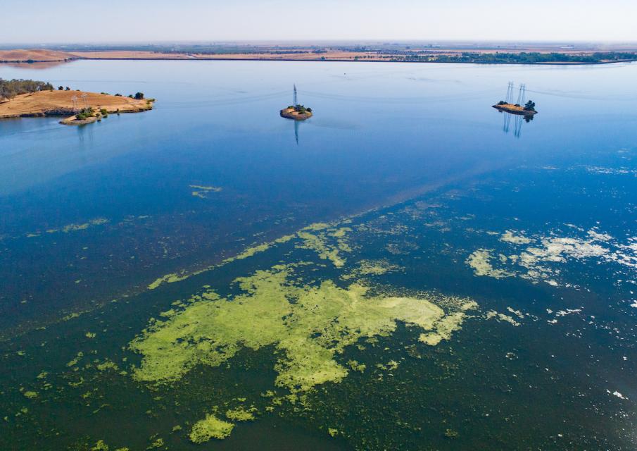
Aerial photo of algal blooms in O'Neill Forebay in Merced County.y

Algal blooms are sudden overgrowths of algae. Their occurrence is increasing in California’s rivers, creeks and lakes and along the coast, threatening the lives of people, pets and fisheries.

Only a few types of algae can produce poisons, but even nontoxic blooms hurt the environment and local economies. When masses of algae die, the decaying can deplete oxygen in the water to the point of causing devastating fish kills.

The blooms typically occur in the summer when hot temperatures and plentiful sunlight coincide with low water levels and excessive nutrients, particularly phosphorous and nitrogen, often caused by stormwater runoff of fertilizers, sewage and manure from the land. 

What’s the danger?

Blue-green algae known as cyanobacteria cause most freshwater blooms of public health concern, according to the federal Centers for Disease Control and Prevention (CDC).

Exposure to cyanobacteria can cause eye irritation, allergic skin rash, mouth ulcers, vomiting, diarrhea and cold- and flu-like symptoms. Young children are most likely to be affected because of their small body size and tendency to play longer in the water.

Dogs also are vulnerable and can die from exposure because they tend to drink while in the water and lick their fur afterward. Even livestock and other animals can get sick or die, sometimes within minutes, from swallowing toxins from cyanobacterial blooms.

Some marine algae produce dangerous levels of domoic acid. While commercial seafood is generally regulated for safe consumption, recreationally caught fish and crustaceans are unregulated and could carry dangerous levels of the neurotoxin.

What are algae?

Organisms that photosynthesize but lack the formal water circulation structure of land plants are placed in the broad category of “algae.” These can grow in fresh water or salt water as single cells, often in colonies, or multicellular organisms such as giant kelp.

Algae are so prolific that their photosynthesis produces approximately half of the planet’s oxygen, making them essential to our survival. Old algae deposits also make up a portion of petroleum products and living or recently dead algae serve as food and shelter for innumerable species

How can I determine if an algal bloom is harmful?

You can’t tell whether a bloom is harmful just by looking at it. Even when you can’t see a bloom, the toxins can still be in the water, the CDC says.

Despite their name, blue-green algae are not restricted to blue-green colors and can appear green, yellowish-brown or red.

Nontoxic algae are also green, so the colors of blooms are not always reliable indicators of toxicity. Harmful blooms in salt water are often referred to as “red tides,” because their density can cause the color of the water to turn red, as well as green or brown.

Harmful algal blooms in fresh water are more difficult to detect than colorful red tides on coastlines but have characteristic patterns that can be recognized from the surface. Grouping in parallel streaks or clumped dots usually indicates toxicity, as does the semblance of spilled green paint or thick pea soup. Alternatively, nontoxic algae generally appear as floating rafts, scum or tangled hair.

How is California responding?

California has a Harmful Algal Bloom Monitoring and Alert Program to mitigate, predict and prevent harmful algal blooms. It also provides updates on current algal blooms. The state Department of Fish and Wildlife posts health advisories and fishing restrictions to protect the public from harmful algae.

State health officials advise swimmers and pets exposed water with blooms to rinse immediately with tap water. People should not drink, cook or wash dishes with untreated surface water from these areas. Common water purification techniques such as camping filters, tablets and boiling do not remove toxins.

  • Print-friendly

Referring Pages

Share this page

  • Share on Facebook
  • Share on Twitter
  • Share on LinkedIn
  • Sent to a friend.
Print-friendly

Related Links

Aquapedia background September 8, 2016 California Water Map Layperson's Guide to California Water
Maps & Posters April 17, 2014 California Water Bundle

California Water Map
Updated December 2016

A new look for our most popular product! And it’s the perfect gift for the water wonk in your life.

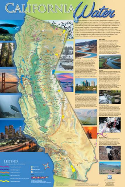
Our 24×36-inch California Water Map is widely known for being the definitive poster that shows the integral role water plays in the state. On this updated version, it is easier to see California’s natural waterways and man-made reservoirs and aqueducts – including federally, state and locally funded projects – the wild and scenic rivers system, and natural lakes. The map features beautiful photos of California’s natural environment, rivers, water projects, wildlife, and urban and agricultural uses and the text focuses on key issues: water supply, water use, water projects, the Delta, wild and scenic rivers and the Colorado River.

  • Read more
Publication May 20, 2014 California Water Map

Layperson’s Guide to California Water
Updated 2021

The 24-page Layperson’s Guide to California Water provides an excellent overview of the history of water development and use in California. It includes sections on flood management; the state, federal and Colorado River delivery systems; Delta issues; water rights; environmental issues; water quality; and options for stretching the water supply such as water marketing and conjunctive use. New in this 10th edition of the guide is a section on the human need for water. 

  • Read more
Back
This item appears in:
  • A
  • Topic List: Environmental Issues
  • Topic: Water Quality
  • Topic List: Water Quality
Footer pod May 20, 2014

Water Education Foundation

Copyright © 2025 Water Education Foundation. All rights reserved.

The Water Education Foundation is a nonprofit, tax-exempt, 501(c)3 organization, federal tax ID #942419885.

Privacy Policy

Donor Privacy Policy

  • Read more
Footer pod May 20, 2014

Contact Information

2151 River Plaza Drive, Suite 205
Sacramento CA 95833

Telephone (916) 444-6240

Contact Us via email

  • Read more

Quicklinks

Footer quicklink May 20, 2014

Contact Us

  • Read more
Footer quicklink May 20, 2014

Donate Today

  • Read more
Footer quicklink May 20, 2014

Tours

  • Read more
Footer quicklink May 20, 2014

Newsletter Signup

  • Read more
Footer quicklink May 20, 2014

Foundation News

  • Read more
Footer quicklink May 20, 2014

Calendar

  • Read more

Log in

  • Create new account
  • Request new password

Commands

  • Support portal
  • Log in