Finding the Right Balance: Managing Delta Salinity in Drought
September/October 2014
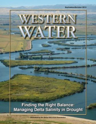
In wet years, dry years and every type of water year in between, the daily intrusion and retreat of salinity in the Sacramento-San Joaquin Delta is a constant pattern.
The cycle of ebb and flood is the defining nature of an estuary and prior to its transformation into an agricultural tract in the mid-19th century, the Delta was a freshwater marsh with plants, birds, fish and wildlife that thrived on the edge of the saltwater/freshwater interface.
Later, after the construction of the Central Valley Project and the State Water Project, the Delta became the critical juncture of the state’s water delivery system. In dry years, that system requires a carefully orchestrated manipulation of reservoir releases to maintain the balance between salty and freshwater conditions. That task has been challenging the past few years with a string of dry winters.
“The Delta drains roughly 40 percent of California,” says the 2014 Central Valley Project and State Water Project Drought Operations Plan and Operational Forecast. “Enough fresh water must flow into the Delta throughout dry months to repel saltwater that pushes inland on ocean-driven tides from San Francisco Bay. If there is not enough water in upstream reservoirs to release to rivers to repel the saltwater, it can contaminate the channels from which water supplies are drawn, not just for the SWP and CVP, but also for Delta farmers and water districts in nearby Contra Costa, Alameda, and San Joaquin counties. Maintaining enough reservoir storage to control Delta salinity this spring through the fall is critical.”
Introduction
As 2014 dawned, California was falling deeper into the depths of a dry season that was rewriting the history books. State and federal officials in charge of Delta water quality and wildlife habitat were forced to take urgent actions to keep saltwater out of the Delta.
“The bigger overarching challenge to salinity management this year was the lack of water in storage,” John Leahigh, chief of water operations for the Department of Water Resources (DWR), told the Delta Stewardship Council in July. “As of late January, we had the driest precipitation level on record for Northern California. We were losing storage.”
Things were getting so perilous that the Delta Cross Channel Gates were opened to maintain salinity standards in the southern and central Delta. Storms in February and March offered some reprieve but it was clear the severity of the drought meant there would be an ongoing task to maintain salinity control.
Because of the need to hold on to what little water was in the rim reservoirs, the State Water Resources Control Board (State Water Board) relaxed water quality standards for Delta salinity to allow more water to remain upstream.
“Given how dry it was, the agencies really came together and it shows that the management is effective,” said Les Grober, assistant deputy director with the State Water Board.
From an environmental perspective, the drought and resulting water quality conditions have been hard on an ecosystem that struggles under the weight of many adverse conditions.
“It’s more salty in the Delta this year than it had been or should be and that affects a lot of fish and a lot of wildlife that are adapted to conditions that arise from greater flow of freshwater into and through the Delta,” said Jon Rosenfield, conservation biologist with The Bay Institute. “In years like this, when water quality protections are eliminated to allow for more storage and diversion of water than would usually be allowed, the flows are so negligible that the estuary begins to not function like an estuary anymore.”
Conditions in the Delta were altered first by diversions of water for agriculture followed by the construction of Shasta, Oroville, Folsom and Friant dams.
“Before the major dams were built, the upper edge of the salinity gradient moved deep into the Delta during drier years,” DWR’s Water Plan Update 2013 says. “The salinity reached as far as Stockton on the San Joaquin River and beyond Courtland on the Sacramento River.” The Plan notes that “some evidence indicates the current (less variable) salinity regime may favor invasive species to the detriment of native species.”
Paul Marshall, who heads DWR’s Bay-Delta office, said “the battle line is at every station that we have to meet a standard whether that standard is given to us like the one for the North Delta Water Agency or the State Water Board’s Decision 1641 or a biological opinion.
“Wherever something is written down, that becomes a battleground,” he said.
The battleground shifted earlier this year after reservoir releases were slowed to preserve water for later. As a result, the edge of the low salinity zone moved upstream to Collinsvillle from its regulated location west of Chipps Island.
The discussion of Delta salinity often invokes “X2,” the point identified by its distance from the Golden Gate Bridge where salinity at the river’s bottom is about 2 parts per thousand (ppt) and is the basis for standards to protect aquatic life (seawater salinity is about 35 ppt).
X2 differs from other standards designed to protect agricultural, municipal and industrial uses. It is a more broadly based standard designed to protect estuarine habitat and the aquatic organisms and food web relationships that are dependent on the quality and quantity of that habitat. It is also specifically designed to incorporate the natural variability of the Bay-Delta’s hydrology, with salinity requirements changing based on monthly changes in natural runoff in the watershed.
X2 “moves several kilometers every few hours twice per day – so we average it out,” Leahigh said.
Rosenfield said X2 “is a good unit for management because it is a metric that captures many different biological and physical effects,” and that as the annual spring value of X2 moves towards the Golden Gate, “numerous fish and plankton populations increase abundance or survival.”
He acknowledged that “it is not clear, for most of the fish or zooplankton populations studied, what the mechanisms are that drive the relationship — is it ‘flow’ or the position of the salinity field that results from flow – and that the mechanism likely differs for different species and even different life stages of those species.”
Salinity management is a key component of the Bay Delta Conservation Plan (BDCP), the controversial proposal that would re-route water under the Delta through twin tunnels while completing 145,000 acres of habitat restoration for 57 species of plants and wildlife.
The BDCP aims to “improve habitat conditions for covered fish in the Delta and downstream in the low-salinity zone of the estuary in Suisun Bay through the integration of water operations with physical habitat enhancement and restoration.”
However, in an Aug. 26 letter to the National Marine Fisheries Service, the U.S. Environmental Protection Agency’s (EPA) San Francisco office wrote that salinity is “expected to increase due to changes in hydrodynamics” of the BDCP and that because “the feasibility of mitigation actions for [salinity] is uncertain … the net effect to overall salinity levels is unclear.”
Southern Delta salinity is often largely influenced by the flow of concentrated salt build-up into the Delta from the San Joaquin River system. This is critical to Delta farmers, who rely on adequate water to irrigate their crops. Salt negatively affects the quality of the soil itself as well as the plants grown in it. Salt in the root zone means the plant has to exert more energy to get water, stunting its growth and limiting the crop yield.
The situation was not always thus, according to John Herrick, manager of the South Delta Water Agency. “When dry times resulted in ocean salts intruding significantly, the San Joaquin River was still fresh and provided protection for the area,” he wrote in an email to Western Water. “Now, the river flow is strangled off by upstream development and the only water left is polluted with CVP salts. Thus, it’s the river salts and not the ocean that threatens us.”
In a 2014 paper called “Agricultural Losses from Salinity in California’s Sacramento-San Joaquin Delta,” several authors with the University of California, Davis wrote that increasing salinity may not be that harmful for Delta agriculture.
“Because locations likely to experience the largest salinity increases already have a lower-value crop mix, the worst-case losses are less than 1 percent of total Delta crop revenues,” according to the paper, published in the journal, San Francisco Estuary and Watershed Science.
“This result also holds for salinity increases from permanent flooding of western islands that serve as a salinity barrier,” according to the paper. “Our results suggest that salinity increases could have much smaller economic effects on Delta farming than other likely changes in the Delta such as retirement of agricultural lands after large-scale flooding and habitat development.”
The drought has magnified the concern by urban water providers that their precious supply is being used inequitably to satisfy Delta water needs such as salinity control.
“I don’t think they spread the pain evenly,” said Tom Gohring, executive director of the Sacramento Water Forum. “Programmed into the National Marine Fisheries Service biological opinion is a bias toward water quality in the Sacramento River over the American River. That’s because they have five endangered species and we have one. I think the imbalance is too much frankly. The American is asked to give more.”
Gohring told Western Water in early August that he believed too much water was being released from Nimbus Dam for downstream temperature control.
“It’s running higher than it should be right now,” he said.
The Water Forum is developing what it calls “a carryover storage alternative” for Folsom Lake to ensure an equitable allocation of water on the lower American River.
“The storage in Shasta has a carryover storage target – they have real restrictions on what they can release and that puts more pressure on Folsom and that’s exactly the situation we are in this year,” Gohring said.
In an email to Western Water, the Bureau of Reclamation’s Mid-Pacific Region wrote that releases on the Sacramento River “are being carefully balanced with Folsom releases considering the projected conditions and various downstream requirements through the remainder of the year.”
“The releases to the American River this year were consistent with the requirements of the current biological opinions both in-stream flows for the American River as well as meeting fishery objectives in the Sacramento-San Joaquin Delta,” Reclamation officials wrote. “In addition, stored water from Folsom Reservoir, and flow releases to the American River, were used to meet water supply needs to both senior water rights holders and to CVP water service customers, and to meet various permit terms and conditions related to Reclamation’s water rights permits.”
Salinity is of such importance because of the need to keep Delta water quality balanced for the needs of people and the environment. “It always takes less water to maintain salinity control then to regain it once it’s lost,” Grober said. “Once you let that salt into the Delta, it takes a much larger quantity of fresh water to push it back out.”
Delta water sometimes contains relatively high concentrations of bromide, organic carbon, nutrients and dissolved solids. “These drinking water constituents of concern are not directly harmful in drinking water, but they lead to formation of harmful chemicals during drinking water treatment, or contribute to taste, odor, or other municipal water supply problems,” the Delta Plan says, adding that salt in municipal water supplies increases corrosion of pipes and appliances.
In its general plan, the city of Antioch, which relies exclusively on the Delta for its drinking water supply, notes that water quality in the San greatly during the course of a year,” and that “generally, the water quality is best during the spring when winter snows have thawed and the salinity of the River is at a minimum.”
The city is investigating the possibility of pursuing a desalination plant to make the brackish river water more suitable for drinking. Elsewhere, the Contra Costa Water District (CCWD), East Bay Municipal Utility District, Santa Clara Valley Water District, San Francisco Public Utilities Commission and Zone 7 Water Agency have identified a $175 million regional desalination plant as a potential new investment in water supply reliability.
The CCWD, which relies on the Delta, believes its source water “has become far more saline in the past 100 years because of human activity,” with salinity intrusion today “typically 3 to 15 miles farther into the Delta compared to the early 20th century, when much less fresh water was diverted.”
The district is concerned that “without seasonal freshening, contaminants and toxics can accumulate in the system.”
The situation reflects the complexities that arose with the development of the SWP and the CVP, Delta users say.
“The projects have been operating for 50 years or more,” Herrick told the Delta Stewardship Council. “The salt issue has been known from the very beginning and people have struggled with how to solve it and there’s not an easy answer.”
This issue of Western Water examines the challenges associated with maintaining Delta salinity – especially in a drought year.
By Gary Pitzer
Click here to find out how to purchase a digital subscription so you can read the complete digital issue.
Editor’s Note
I’m an eternal optimist but when it comes to this drought that has a stranglehold on California, it is getting harder and harder to be so.
Earlier this year, the state appeared headed to an El Niño weather pattern that would bring additional rain to parts of the state this winter. But it has lost so much steam that Bill Patzert, a well-known climatologist from NASA’s Jet Propulsion Laboratory, dubbed it “El Wimpo” as he showed satellite images reflecting a much weaker El Niño pattern in the Pacific Ocean to those gathered at the San Bernardino County Water Conference.
The images left by the drought are daunting; water in once healthy reservoirs across the state is retreating farther and farther from shore, revealing dry, cracked lakebeds. Residential rationing is happening in cities like Santa Cruz. Satellite images are showing a shocking loss of groundwater in California. The drought has moved fast and furious across the state this past year, leaving 82 percent in an “extreme drought” and more than half, at 58 percent, in the worst category known as an “exceptional drought,” according to the latest U.S. Drought Monitor released Oct 9.
Thus, even though, I’m quite conscious of the water I use on a daily basis, I’m going to participate in the 4Liters Challenge, which was launched Oct. 6 by the Los Angeles-based human rights nonprofit DIGDEEP. Much like the ALS ice bucket challenge, this one challenges people to use only four liters to wash, drink and bathe for 24 hours, and then they can challenge four more people. According to the U.S. Geological Survey and others, the average American uses more than 400 liters of water at home.
Just the thought of living on 4 liters has got me thinking about how I’m using my water on a daily basis. It’s already pretty good, but could it be better? To know that I’m living within exactly 4 liters I will parcel out my daily water into four recycled, one-liter bottles. I’ll mark them for drinking, washing, bathing, brushing teeth, and other uses. I already use dry shampoo every other day so I’ll be sure to do that. I hope readers of Western Water will join me in taking the challenge. If so, you can check out the details at 4liters.org. And, you can find more tips on conserving water in and outside your home on our website: www.watereducation.org.
The drought can also do more than shrink reservoirs; it can cause salinity to creep further into the Delta, the hub of the state’s water supply. This issue of Western Water, which often looks at issues not highlighted in the general media, explores in-depth what is going on this year with salinity in the Delta. Be sure to let us know what you think after reading it.