Header link June 22, 2020

LinkedIn

  • Read more
Header link September 15, 2014

Cart

  • Read more
Header link November 3, 2015

Donate Now

  • Read more
Header link May 15, 2014

Twitter

  • Read more
Header link May 15, 2014

Facebook

  • Read more
Instagram
Header link May 15, 2014

Instagram

  • Read more
Header link May 15, 2014

Contact Us

  • Read more
More options
Water Education Foundation
Home

Water Education Foundation

Everything about California water that matters
  • Water Academy
    • Agriculture
      • Agricultural Conservation
      • Agricultural Drainage
    • Background Information
      • Legislation — California and Federal
      • Regulations — California and Federal
      • Water History
      • Water Rights
    • Bay-Delta
      • Bay Delta
      • Bay Delta Conservation Plan
      • Delta Issues
      • Delta Smelt
      • Sacramento San Joaquin Delta
      • San Francisco Bay
      • Suisun Marsh
    • Dams, Reservoirs and Water Projects
      • California Aqueduct
      • Central Valley Project
      • Folsom Dam
      • Friant Dam
      • Hetch Hetchy
      • Hoover Dam
      • Infrastructure
      • Lake Mead
      • Lake Powell
      • Oroville Dam
      • San Luis Dam
      • Shasta Dam
      • State Water Project
    • Environmental Issues
      • Anadromous Fish Restoration
      • Ecosystem
      • Endangered Species Act
      • Invasive species
      • Lake Tahoe
      • Mono Lake
      • Public Trust Doctrine
      • Salmon
      • San Joaquin River Restoration
      • Watershed
      • Wetlands
    • Leaders and Experts
    • Regions
      • Central Coast
      • Central Valley
      • Mexico
      • Nevada
      • North Coast
      • Pyramid Lake
      • Sacramento Valley
      • Salton Sea
      • San Joaquin Valley
      • Sierra Nevada
      • Southern California
      • Tulare Lake Basin
    • Rivers
      • Carson River
      • Colorado River
      • Klamath River
      • New River
      • North Coast Rivers
      • Russian River
      • Sacramento River
      • Truckee River
      • San Joaquin River
    • Water Issues
      • Climate Change
      • Coronavirus
      • Drought
      • Earthquakes
      • Energy and Water
      • Floods
      • Fracking
      • Growth
      • Hydropower
      • Levees
      • Tribal Water Issues
      • Water Conservation
      • Water Equity
    • Water Quality
      • Drinking Water
      • Nitrate contamination
      • Pollution
      • Stormwater
      • Wastewater
      • Water Quality
    • Water Supply and Management
      • Acre Foot
      • Aquifers
      • California Water Plan
      • Conjunctive Use
      • Desalination
      • Grey water
      • Groundwater
      • Integrated Regional Water Management
      • Recreation
      • Surface Water
      • Water Marketing and Banking
      • Water Rates
      • Water Recycling
      • Water Supply
      • Water Transfers
  • Tours & Events
    • Water Tours
      • 2023 Tour Sponsors
    • Events
    • Event Calendar
    • Past Tours & Events
      • Anne J. Schneider Fund Lecture Series
  • Specialized Programs
    • Water Leaders
      • Class Rosters
      • Yearly Class Reports
      • Your Alumni Network
      • Alumni Profiles
    • Project WET
      • Workshops
      • Special Workshops & Events
      • Supplementary Materials
      • California Content Standard Correlations
      • Facilitator's Trainings
      • Foundation School Programs
        • Elementary Programs
        • Secondary Programs
      • Water Kids
      • California Project WET Gazette
      • Gazette Archives
    • Colorado River Project
    • GRA Scholastic Fund Program
  • Maps & Guides
    • Maps & Posters
    • Layperson's Guides
    • Map & Guide Bundles
    • Books
    • Colorado River Materials
    • California Runoff Rundown
    • Other Publications
    • Water Awareness Materials
    • Downloadable Publications
    • Videos and DVDs
      • Video Clips
    • School Age Publications
    • Stickers
    • Free Programs and Publications
  • Newsroom
    • Western Water News
    • Aquafornia
      • About Aquafornia
    • Information Desk
    • Western Water Magazine Archive
      • Full Print Edition
      • Print Edition Excerpts
    • River Report Archive
  • Aquapedia
    • Alphabetical List of Subjects
      • A
      • B
      • C
      • D
      • E
      • F
      • G
      • H
      • I
      • J
      • K
      • L
      • M
      • N
      • O
      • P
      • Q
      • R
      • S
      • T
      • U
      • V
      • W
      • X
      • Y
      • Z
    • Historical Water People
    • Where Does My Water Come From?
      • Northern California
      • Sacramento
      • North Bay
      • South Bay
      • Central Valley
      • Los Angeles
      • Inland Empire
      • San Diego
      • All California Water Sources
    • Timelines
    • Videos
    • Image Gallery
    • Water Directory
      • Federal Agencies
      • State Agencies in California
      • Environmental Organizations
      • Other California Organizations
      • State and Federal Legislative Committees
      • Water Associations and Groups
      • Western States Water Agencies and Districts
    • Online Resources
    • Useful Acronyms
    • About Aquapedia
  • About
    • About Us
      • Board of Directors
      • Staff Biographies
      • Job Openings
    • Announcements
    • Support Our Mission
      • Become a Member
      • Donate in Honor/Memory
      • Donate to Aquapedia or Aquafornia
      • Shop Amazon
      • Planned Giving
    • Contact Us
Aquapedia background February 11, 2014

Sacramento-San Joaquin Delta Levees

Sacramento-San Joaquin Delta Levees

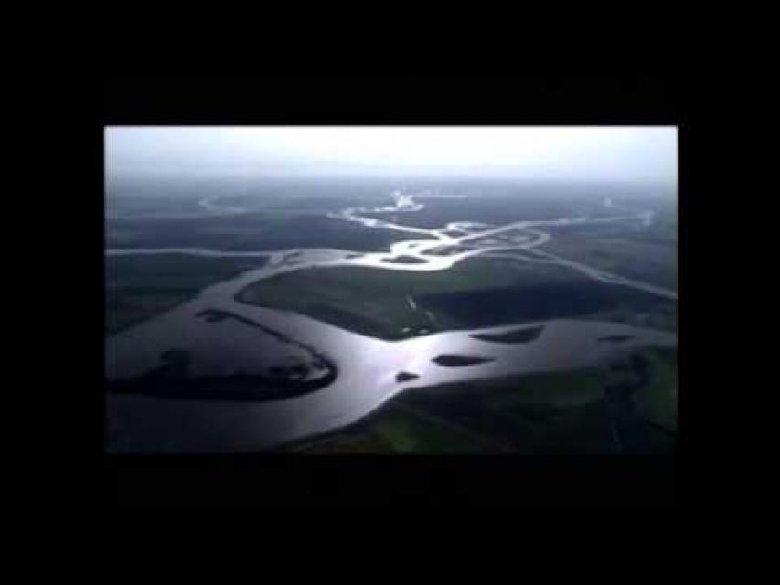
Roughly 1,115 miles of levees protect farms, cities, schools and people in and around the Sacramento-San Joaquin Delta, a crucial conduit for California’s overall water supply. But the Delta’s levees are vulnerable to failure due to floods, earthquakes and rising sea levels brought about by climate change. A widespread failure could imperil the state’s water supply.

Since the 19th century, levees — from the French word ‘lever’, or ‘to raise’ — have been erected to protect “reclaimed” marshland, popularly referred to as Delta islands. The levees were built to prevent flooding and allow cultivation of the rich soil while protecting public infrastructure such as highways and pipelines.

Farmers first thought levees 4 feet high and 12 feet at the base would protect Delta lands from tides and river overflow, but that proved inadequate for Delta peat soils.

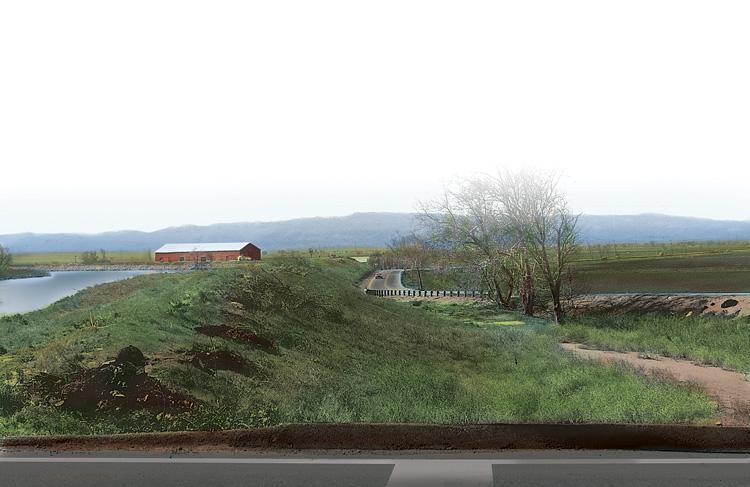
Progressively higher levees were built to keep the surrounding waters out, the lands were pumped dry and the marsh was transformed into productive island farms, mostly below sea level.

Today, some islands are 25 feet or more below sea level and beneath the water level in the surrounding channels. Climate change also portends more drastic rises in water levels, adding even more pressure on critical levees.

Sacramento-San Joaquin Delta Levees Overview

Delta levees are classified as project or non-project levees. Project levees are part of the Federal Flood Control Project and are built to higher standards that comply with U.S. Army Corps of Engineers guidelines.

Delta levees are distinguished from river levees in that they are constantly holding back water, making them more comparable to dams. Unlike dams, however, Delta levees were not constructed with strict engineering standards to withstand the constant pressure of water from the daily cycle of tides, wind and boat wakes.

Once complete, the levees are maintained by local agencies and periodically inspected by the Corps. Non-project levees, comprising 65 percent of Delta levees, are those constructed and maintained by island landowners or local reclamation districts. These levees are generally built to an agricultural standard and are typically less stable than project levees. 

On many Delta islands, the levee foundations are composed of the same peat soil formed by the marsh’s original vegetation. This organic soil is rich in nutrients, but it oxidizes (vaporizes quickly), resulting in as much as 1.5 inches of soil loss per year. Oxidation, combined with compaction and settling, is known as subsidence—a critical problem because the process puts additional stress on levees.

When levees fail, water rushes into the lower-than-sea level islands, pulling in saltwater from San Francisco Bay and reducing water quality. Widespread flooding due to levee failure could force a long-term shutdown of the State Water Project and federal Central Valley Project pumps in the south Delta near Tracy that supply much of California with water. Delta levees also protect an extensive network of public utilities (pipelines, highways, rail lines), preserve extensive farmland and facilitate significant recreational opportunities.

Since 1980, 27 Delta islands have been partially or completely flooded, including a 2004 levee break at Upper Jones Tract that cost about $90 million to repair. As with all working structures, the Delta levees are continually deteriorating and must be regularly maintained, something that costs millions of dollars annually.

In some cases, allowing some Delta islands such as Little Holland Tract and Liberty Island to flood can be helpful as a release valve for excess water. Similarly, farmland set aside for deliberate flooding is also being explored. These flooded spaces can also provide ecosystem benefits.

Sacramento-San Joaquin Delta Levees Protection

The Sacramento-San Joaquin Delta’s vulnerability to natural disaster has been highlighted by scientific analyses calculating the probability of levee failure from floods or earthquakes.

Hurricane Katrina in 2005, for instance, demonstrated the level of destruction that could be unleashed by a series of breached levees. Although levee vulnerability in California’s Delta is not easy to quantify, it is estimated that multiple levee breaches are very likely in the event of a large earthquake. Similarly, California’s capital, Sacramento, is one of the most at-risk cities for a major flood in the United States.

Following significant floods in 1986, California’s legislature enacted the Delta Flood Control Protection Act to improve funding for levee maintenance and repair. The flood protection act provided $12 million a year for 10 years for levee improvements, and developed flood control plans for eight western Delta islands and the communities of Thornton and Walnut Grove.

Since then, the flood control protection plan has been extended and has significantly improved levee maintenance, repair, and emergency response in the Delta.

Additionally, two bond measures passed in November 2006 allocated more funds for flood control in the Delta. And in 2018, yet another bond measure allocated $1.27 billion for levee repairs.

  • Print-friendly

Referring Pages

Share this page

  • Share on Facebook
  • Share on Twitter
  • Share on LinkedIn
  • Sent to a friend.
Print-friendly

Related Links

Aquapedia background February 11, 2014
Back
This item appears in:
  • Topic: Sacramento San Joaquin Delta
  • Topic: Levees
  • S
Footer pod May 20, 2014

Water Education Foundation

Copyright © 2023 Water Education Foundation. All rights reserved.

The Water Education Foundation is a nonprofit, tax-exempt, 501(c)3 organization, federal tax ID #942419885.

Privacy Policy

Donor Privacy Policy

  • Read more
Footer pod May 20, 2014

Contact Information

2151 River Plaza Drive, Suite 205
Sacramento CA 95833

Telephone (916) 444-6240

Contact Us via email

  • Read more

Quicklinks

Footer quicklink May 20, 2014

Contact Us

  • Read more
Footer quicklink May 20, 2014

Donate Today

  • Read more
Footer quicklink May 20, 2014

Tours

  • Read more
Footer quicklink May 20, 2014

Newsletter Signup

  • Read more
Footer quicklink May 20, 2014

Foundation News

  • Read more
Footer quicklink May 20, 2014

Calendar

  • Read more

Log in

  • Create new account
  • Request new password

Commands

  • Support portal
  • Log in