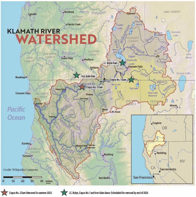
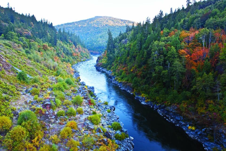
The Klamath River flows 253 miles
from Southern Oregon to the California coast, draining a basin of
more than 15,000 square miles. The watershed and its fisheries
have been the subject of negotiation since the 1860s negotiations
that have intensified and continue to this day.
The river has provided irrigation to ag lands since the late 19th
century. Agricultural development drained vast areas of
wetlands on the periphery of Upper Klamath Lake and in
upstream watersheds. Some of this drained acreage has been
restored and is now managed primarily for wetland benefits.
The watershed is divided geographically into two basins, upper
and lower, divided by Iron Gate Dam, the lower most dam on the
river. The Upper Basin is dry, with annual precipitation of about
13 inches at the river’s origin near Klamath Falls, Ore.
Downstream, the climate grows wetter.
Native Americans have a significant presence in the Klamath
Basin. Four major tribes have been influential in water
negotiations: the Klamath Tribes, the Karuk Tribe, the Hoopa
Valley Tribe and the Yurok Tribe.
Get ready for the latest scoop on the Klamath River dam removal
and restoration project! In the newest episode of the Fish
Water People Podcast, Mark Bransom, CEO of the Klamath River
Renewal Corporation, is welcomed back to discuss exciting
updates on the once-in-a-lifetime restoration effort. In recent
months, significant milestones have been achieved, with
successful dam breaching at Iron Gate, Copco 1, and J.C. Boyle
in Southern Oregon – signifying a monumental leap forward in
the journey to restoring river vitality. Despite expected
challenges such as sediment management and ecological
adjustments, the project remains steadfast on its course.
Native vegetation is already beginning to sprout, breathing new
life into the ecosystem. Curious what lies ahead on this
monumental journey of renewal?
For the past two years, Mt. Shasta has emerged from winter
covered in thick blankets of white snow that conceal what
decades of drought have done to the Northern California
mountain’s ancient glaciers. The seasonal snows come and go on
the 14,179-foot peak. For hundreds of years, the glaciers have
clung to the mountain’s steep slopes, slowly changing and
moving over time. But for the past few decades, droughts and
periods of abnormally warm weather have caused the glaciers to
shrink. Scientists have studied the glaciers and documented
their demise as climate change — with its warmer temperatures
and dearth of snow — has slowly caused Mt. Shasta’s glacial
masses to dwindle, especially during the 2020-22 drought.
While work crews continued dismantling dams on the Klamath
River, leaders of four tribes gathered on a riverbank last week
to watch and offer prayers as a valve on a tanker truck was
opened. Over two days, workers from the California
Department of Fish and Wildlife released 16 truckloads of
juvenile salmon that were raised in a newly built
hatchery. … The last time state workers released
Chinook salmon in February, they let loose more than 800,000
fish in a tributary upstream of Iron Gate Dam, which is slated
to be removed, and the fish were later found dead in the
river. Biologists determined the salmon died as they passed
through a tunnel beneath the dam. To prevent that from
happening again, state officials selected another location just
downstream of Iron Gate Dam.
… The main reason is the decline of the salmon population in
the Sacramento River to such an unsustainable level that
there’s reason to fear that it may not recover for years, if
ever — unless government policies are radically reconsidered.
… The crisis underscores the utter failure of the state’s
political leaders to balance the needs of stakeholders in its
water supply. In this case, the conflict is between large-scale
farms on one side and environmental and fishery interests on
the other. For decades, agribusiness has had the upper
hand in this conflict. -Written by Michael Hiltzik, LA Times columnist.
The Bureau of Reclamation today announced the initial 2024
water supply allocations for the Klamath Project along with
$8.5 million in immediate funding for the Klamath Basin
communities to support drought resiliency and $5 million for
Klamath Basin tribes impacted by drought. In partnership with
the Klamath Project Drought Response Agency, Reclamation has
secured $8.5 million for administration of specifically
authorized drought resiliency programs targeted for project
contractors who receive a reduced water allocation. Reclamation
is announcing this funding together with an additional $5
million from separate program sources which will be disbursed
through technical assistance agreements with Klamath Basin
Tribal Nations for drought and ecosystem activities.
For the second year in a row, there will be no commercial or
recreational salmon fishing in California. … The Golden
State Salmon Association supports the recommendation of the
[Pacific Fishery Management Council], which works closely with
federally recognized West Coast tribes, many who define
themselves as “salmon people” and hold annual ceremonies to
honor their return each year. Bates said $20.6 million has
been allocated from the U.S. Department of Commerce to
compensate for some of the losses caused by last year’s closure
to charter fleets and commercial fleets, buyers and processors.
But the fisheries are calling on the state to allocate water,
not cash. Scott Artis, executive director of the Golden
State Salmon Association, said big agriculture is not limited
in their water use, but fisheries get hit with constraints.
The California Department of Fish and Wildlife will be joined
by Tribal leaders and fisheries experts to release over 500,000
salmon into the Klamath River Tuesday. According to CDFW, this
will be the first major release of Coho Salmon into the river
since the drawdown of Klamath River reservoirs as part of the
dam removal currently underway.
California fishermen spoke out against state water management
policies Thursday after federal fishing officials canceled
ocean salmon fishing season in the state for the second
consecutive year, delivering a major blow to the fishing
industry. … Salmon stocks have been impacted by the
state’s multi-year drought and climate disruptions, including
wildfires, algal blooms and ocean forage shifts, according to
the California Department of Fish and Wildlife. The salmon
population has also been impacted by rising river water
temperatures in addition to a rollback of federal
protections for waterways by the Trump administration.
In a devastating blow to California’s fishing industry, federal
fishery managers unanimously voted today to cancel all
commercial and recreational salmon fishing off the coast of
California for the second year in a row. The decision is
designed to protect California’s dwindling salmon populations
after drought and water diversions left river flows too warm
and sluggish for the state’s iconic Chinook salmon to
thrive. … Many in the fishing industry say they
support the closure, but urged state and federal officials to
do more to improve conditions in the rivers salmon rely on.
Fishing advocates and environmentalists have lambasted Gov.
Gavin Newsom’s administration for failing to prioritize
water quality and flows to protect salmon in the
vital Bay-Delta watershed.
Klamath, Modoc and Siskiyou County leaders are asking for an
“adequate water supply” on behalf of local irrigation. A news
release from Klamath Water Users Association this week said a
letter has been sent to the Bureau of Reclamation requesting
the full water allocations on behalf of Klamath Project
irrigators. The letter, sent to Reclamation Commissioner
Camille Calimlim Touton, bases the request for increase water
flows in congruence with “favorably hydrology” this year in the
Klamath Basin.
The Klamath River in southern Oregon and northern California is
now running freer. In late 2023 and early 2024, four of the six
dams along the river were breached and reservoirs drained.
These actions were part of an effort to restore hundreds of
miles of riparian habitat. It is thought to be the largest dam
removal project in history. The four dams—Iron Gate, Copco No.
1, Copco No. 2, and J.C. Boyle—were built between 1918 and 1962
to generate electricity. Facing steep costs to modernize them
in the early 2000s, the utility that owned the dams opted for
deconstruction instead. In addition to removing aging
infrastructure, the project is expected to eliminate the
ecosystem and human health risks posed by toxic algae, which
has regularly reached harmful levels in the reservoirs since
2005.
After years of heated debates and delays, the world’s largest
dam removal is currently underway on the Klamath River across
the California-Oregon border. … removing structures of
this size come with negative side effects—from droves of dead
fish to muddy waters. As a result, critics have recently spoken
out against the project, deeming it an “environmental
disaster.” But scientists say that they expected many of these
short-term impacts before the effort began and they will soon
fade. For today’s newsletter, I decided to dig into the science
behind dam removal, and how the rocky start to the Klamath
River project could yield a healthier river system overall.
In late March the Siskiyou County Board of Supervisors
proclaimed a local emergency related to concerns about heavy
metals like arsenic and lead being present in the Klamath
River. It was prompted by the ongoing removal of four
hydroelectric dams on the river. … Matt St. John, an
environmental program manager with the North Coast Regional
Water Quality Control Board, said it was expected that you’d
also have high metals concentrations. “Those metals
concentrations are not a threat to public health. It’s okay to
touch the water with those type of concentrations. And no water
in the state of California should be drunk without any without
treatment. And so, the Klamath River isn’t a source of drinking
water without treatment of that water.”
Federal salmon overseers say Oregon Coast Chinook face a low
risk of extinction, according to a recently concluded deep dive
into the health of runs stretching from the Necanicum in the
north to the Elk and Sixes in the south. It’s not the
final word on whether an Endangered Species Act listing is
needed or not, but the 195-page status review does
represent an assessment by the National Marine Fisheries
Service’s Northwest Science Center in response to a petition
filed in 2022 to list the stock and will be a relief to
fishermen and salmon managers. … However, the news
wasn’t as good for Chinook in the Southern Oregon and Northern
California ESU, which stretches from Bandon to the Klamath
River. Even as the overall population is also at low risk of
extinction, key components aren’t doing as well, raising the
risk for the entire stock.
… The season typically runs from May to October, but
California Chinook salmon populations have declined so severely
in recent years that fishery authorities are considering
whether to adopt severe restrictions this season or impose a
ban on fishing altogether for the second consecutive year.
… [Many salmon fishers lay] much of the blame on
California water managers, who [they say] send too much
water to farms and cities and deprive rivers of the cold flows
salmon need to survive.
For the first time in four years, water is being pumped from
Tulelake to the Lower Klamath National Wildlife Refuge. The
historic Pumping Plant D in Tulelake Irrigation District (TID)
was constructed at the base of Sheepy Ridge in 1942. TID
Manager Brad Kirby said the five massive pumps ran year-round
for nearly 70 years. … In 2020, drought conditions and
federal regulations rendered the plant inoperative. As of
Monday morning, the D-Plant is up and running again, pumping
water from the Tulelake National Wildlife Refuge through Sheepy
Ridge to the Lower Klamath refuge thanks to the efforts of TID,
Ducks Unlimited and U.S. Fish and Wildlife.
Near the California-Oregon border, reservoirs that once
submerged valleys have been drained, revealing a stark
landscape that had been underwater for generations. A thick
layer of muddy sediment covers the sloping ground, where
workers have been scattering seeds and leaving meandering
trails of footprints. In the cracked mud, seeds are sprouting
and tiny green shoots are appearing. With water passing freely
through tunnels in three dams, the Klamath River has returned
to its ancient channel and is flowing unhindered for the first
time in more than a century through miles of waterlogged lands.
Klamath Project irrigation districts are preparing to move
water as concerns grow about potential flood releases on Upper
Klamath Lake in the coming weeks. The Klamath Water Users
Association says its members have been concerned over water
management in Upper Klamath Lake. The Klamath irrigation
district says given the possibility of flood conditions in the
coming weeks, it could pose a risk for everyone along the
Klamath River, including those working on dam removals.
Irrigation District Executive Director Gene Souza says their
request to discuss these concerns with the Bureau of
Reclamation has gone unanswered.
The deconstruction of Copco Dam Number One is going to get
underway in the next few weeks, and the Klamath River Renewal
Corporation says it’s all going ahead of schedule. Klamath
River Renewal Corporation (KRRC) CEO Mark Bransom says things
are going exceptionally in the progress of undamming the river.
Sharing, with approval to move forward on Copco Dam Number 1,
they’re now looking at a finish by the end of summer, and only
better days for the Klamath River from there. “They will begin
a series of drilling into the top of Copco Number One, packing
those holes with explosives, detonating those explosives and
the idea is to break up that large concrete dam into more
manageable chunks of concrete,” Bransom said.
After decades of advocating, tribal members cheered as a blast
at JC Boyle Dam this year kicked off the process of drawing
down the reservoirs behind three Klamath River dams. The
removal is expected to restore the river and reopen spawning
habitat that salmon haven’t been able to reach for more than a
century. OPB science reporter and editor Cassandra Profita
brings us the perspective of the tribes living along the
Klamath River: what the country’s largest dam removal project
means to them and their hopes for the future.
The Pacific Fishery Management Council is considering three
options for the ocean salmon season, set to begin May 16. The
federal council that manages water from California, Oregon and
Washington state came up with two options that would entail a
short salmon season, and it’ll come with small harvest limits
for both commercial and sport fishing. The last option includes
closing off the ocean fisheries for the second consecutive
year. Last year, commercial and recreation salmon fleets in
California were left anchored following the PFMC’s decision to
cancel the 2023 fishing season due to years of drought, low
river level and dry conditions affecting the Chinook salmon
populations in the Klamath and Sacramento rivers.
The dam removal projects- aimed at sustaining the salmon
population, are underway, with the latest drawdown being three
reservoirs on the Klamath River. The removal process has
already dramatically changed the landscape in Southern Oregon
and far Northern California, along the course of the river. The
lowest of the three remaining dams- Iron Gate, was initially
breached on January 9, followed by the J.C. Boyle reservoir on
January 16. A concrete plug in the tunnel at the base of Copco
1 was blasted away on January 23, with the reservoirs draining
quickly, leaving vast expanses of fissured mud that was the
consistency and color of chocolate cake batter. Shaping its new
course, the Klamath River is winding through the bare
landscape, but the transformation has had some unintended
consequences and saddened some residents.
…Tuesday, the State Water Resources Control Board took
action to protect the salmon,
unanimously extending the region’s
expired emergency drought measures. Ground and surface
water for farms will be restricted for another year if flows in
the Shasta and Scott rivers dip below minimum thresholds. State
officials say these measures are likely to kick in next
year. Water board chair Joaquin Esquivel said action
is needed because “a fish emergency” remains on the rivers.
“Time isn’t our friend,” he said at a previous meeting in
August. “There is an urgency.” The water board also
is investigating the possibility of permanent requirements to
keep more water in the rivers, after the Karuk Tribe and the
fishing industry petitioned the state for stronger protections.
That decision, however, could take years.
The Klamath River Basin was once one
of the world’s most ecologically magnificent regions, a watershed
teeming with salmon, migratory birds and wildlife that thrived
alongside Native American communities. The river flowed rapidly
from its headwaters in southern Oregon’s high deserts into Upper
Klamath Lake, collected snowmelt along a narrow gorge through the
Cascades, then raced downhill to the California coast in a misty,
redwood-lined finish.
California is chock full of rivers and creeks, yet the state’s network of stream gauges has significant gaps that limit real-time tracking of how much water is flowing downstream, information that is vital for flood protection, forecasting water supplies and knowing what the future might bring.
That network of stream gauges got a big boost Sept. 30 with the signing of SB 19. Authored by Sen. Bill Dodd (D-Napa), the law requires the state to develop a stream gauge deployment plan, focusing on reactivating existing gauges that have been offline for lack of funding and other reasons. Nearly half of California’s stream gauges are dormant.
In 1983, a landmark California Supreme Court ruling extended the public trust doctrine to tributary creeks that feed Mono Lake, which is a navigable water body even though the creeks themselves were not. The ruling marked a dramatic shift in water law and forced Los Angeles to cut back its take of water from those creeks in the Eastern Sierra to preserve the lake.
Now, a state appellate court has for the first time extended that same public trust doctrine to groundwater that feeds a navigable river, in this case the Scott River flowing through a picturesque valley of farms and alfalfa in Siskiyou County in the northern reaches of California.
Headwaters are the source of a
stream or river. They are located at the furthest point from
where the water body empties or merges with
another. Two-thirds of California’s surface water supply
originates in these mountainous and typically forested regions.
Mired in drought, expectations are high that new storage funded
by Prop. 1 will be constructed to help California weather the
adverse conditions and keep water flowing to homes and farms.
At the same time, there are some dams in the state eyed for
removal because they are obsolete – choked by accumulated
sediment, seismically vulnerable and out of compliance with
federal regulations that require environmental balance.
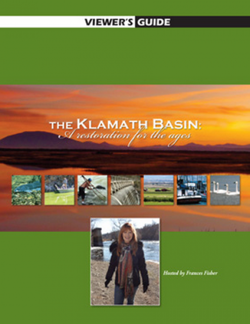
20-minute version of the 2012 documentary The Klamath Basin: A
Restoration for the Ages. This DVD is ideal for showing at
community forums and speaking engagements to help the public
understand the complex issues related to complex water management
disputes in the Klamath River Basin. Narrated by actress Frances
Fisher.
For over a century, the Klamath River Basin along the Oregon and
California border has faced complex water management disputes. As
relayed in this 2012, 60-minute public television documentary
narrated by actress Frances Fisher, the water interests range
from the Tribes near the river, to energy producer PacifiCorp,
farmers, municipalities, commercial fishermen, environmentalists
– all bearing legitimate arguments for how to manage the water.
After years of fighting, a groundbreaking compromise may soon
settle the battles with two epic agreements that hold the promise
of peace and fish for the watershed. View an excerpt from the
documentary here.
This 25-minute documentary-style DVD, developed in partnership
with the California Department of Water Resources, provides an
excellent overview of climate change and how it is already
affecting California. The DVD also explains what scientists
anticipate in the future related to sea level rise and
precipitation/runoff changes and explores the efforts that are
underway to plan and adapt to climate.
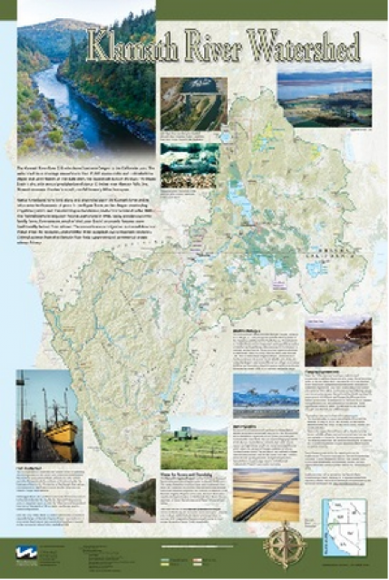
This beautiful 24×36 inch poster, suitable for framing, displays
the rivers, lakes and reservoirs, irrigated farmland, urban areas
and Indian reservations within the Klamath River Watershed. The
map text explains the many issues facing this vast,
15,000-square-mile watershed, including fish restoration;
agricultural water use; and wetlands. Also included are
descriptions of the separate, but linked, Klamath Basin
Restoration Agreement and the Klamath Hydroelectric Agreement,
and the next steps associated with those agreements. Development
of the map was funded by a grant from the U.S. Fish and Wildlife
Service.
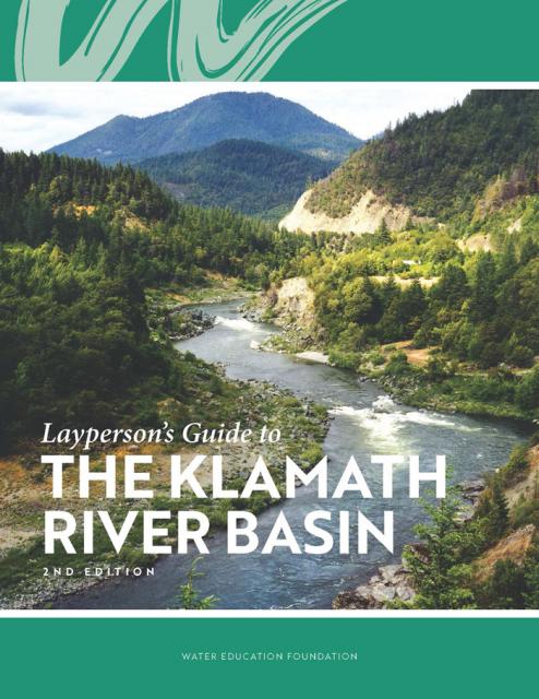
The Water Education Foundation’s second edition of
the Layperson’s Guide to The Klamath River Basin is
hot off the press and available for purchase.
Updated and redesigned, the easy-to-read overview covers the
history of the region’s tribal, agricultural and environmental
relationships with one of the West’s largest rivers — and a
vast watershed that hosts one of the nation’s oldest and
largest reclamation projects.
A new look for our most popular product! And it’s the perfect
gift for the water wonk in your life.
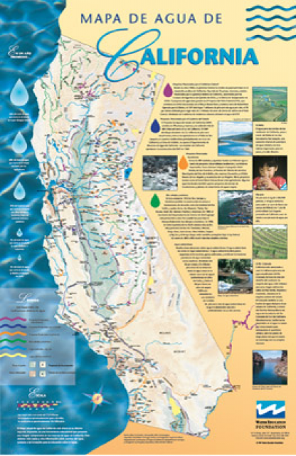
Our 24×36 inch California Water Map is widely known for being the
definitive poster that shows the integral role water plays in the
state. On this updated version, it is easier to see California’s
natural waterways and man-made reservoirs and aqueducts
– including federally, state and locally funded
projects – the wild and scenic rivers system, and
natural lakes. The map features beautiful photos of
California’s natural environment, rivers, water projects,
wildlife, and urban and agricultural uses and the
text focuses on key issues: water supply, water use, water
projects, the Delta, wild and scenic rivers and the Colorado
River.
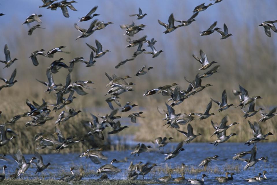
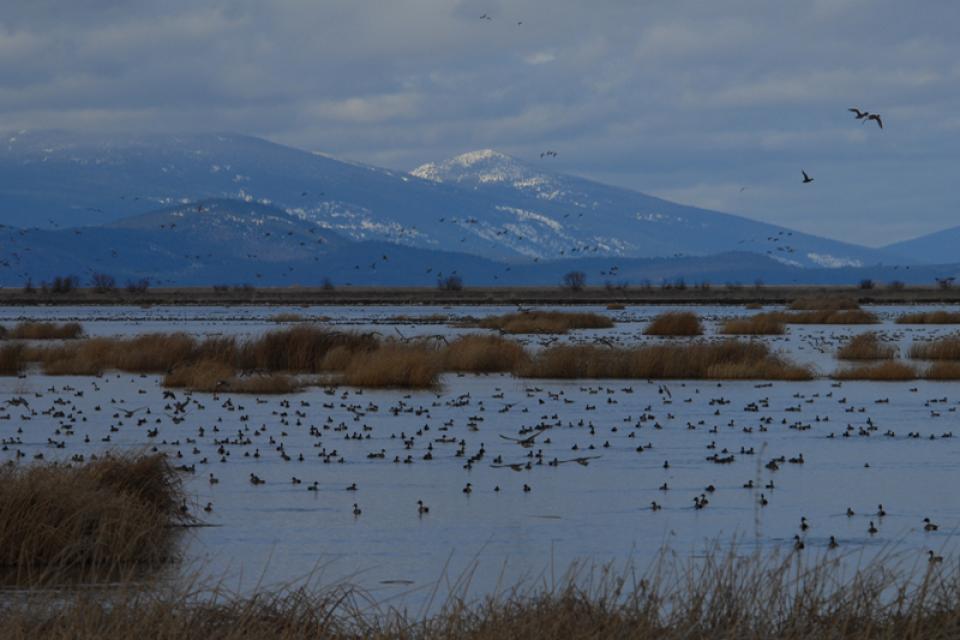
The Pacific Flyway is one of four
major North American migration routes for birds, especially
waterfowl, and extends from Alaska and Canada, through
California, to Mexico and South America. Each year, birds follow
ancestral patterns as they travel the flyway on their annual
north-south migration. Along the way, they need stopover sites
such as wetlands with suitable habitat and food supplies. In
California, 90 percent of historic wetlands have been lost.
The Klamath River Basin is one of the West’s most important and
contentious watersheds.
The watershed is known for its peculiar geography straddling
California and Oregon. Unlike many western rivers, the
Klamath does not originate in snowcapped mountains but rather on
a volcanic plateau.
A broad patchwork of spring-fed streams and rivers in
south-central Oregon drains into Upper Klamath Lake and down into
Lake Ewauna in the city of Klamath Falls. The outflow from Ewauna
marks the beginning of the 263-mile Klamath River.
The Klamath courses south through the steep Cascade Range and
west along the rugged Siskiyou Mountains to a redwood-lined
estuary on the Pacific Ocean just south of Crescent City,
draining a watershed of 10 million acres.
A bounty of resources – water, salmon, timber and minerals – and
a wide range of users turned the remote region into a hotspot for
economic development and multiparty water disputes (See
Klamath River
timeline).
Though the basin has only 115,000 residents, there is seldom
enough water to go around. Droughts are common. The water
scarcity inflames tensions between agricultural,
environmental and tribal interests, namely the basin’s four major
tribes: the Klamath Tribes, the Karuk, Hoopa Valley and Yurok.
Klamath water-use conflicts routinely spill into courtrooms,
state legislatures and Congress.
In 2023, a historic removal of four powers dams on the river
began, signaling hope for restoration of the river and its fish
and easing tensions between competing water interests. In
February 2024, Interior Secretary Deb Haaland
announced a “historic” agreement between tribes and farmers
in the basin over chronic water shortages. The deal
called for a wide range of river and creek restoration work and
modernization of agricultural water supply infrastructure.
Water Development
Farmers and ranchers have drawn irrigation water from basin
rivers and lakes since the late 1900s. Vast wetlands around
Upper Klamath Lake and upstream were drained to grow crops. Some
wetlands have been restored, primarily for migratory birds.
In 1905, the federal government authorized construction of the
Klamath Project, a network of irrigation canals, storage
reservoirs and hydroelectric dams to grow an agricultural
economy in the mostly dry Upper Basin. The Project managed by the
U.S. Bureau of Reclamation irrigates about 240,000 acres and
supplies the Lower Klamath Lake and Tule Lake national wildlife
refuges managed by the U.S. Fish and Wildlife Service.
Water Management
Since 1992, federal mandates to restore populations of fish
protected by the Endangered Species
Act have led in some dry years to drastic cuts in
water deliveries to Klamath Project irrigators.
Water in Upper Klamath Lake must be kept above certain
levels for the endangered shortnose and Lost River suckers. Lake
levels and Klamath River flows below Iron Gate Dam also must be
regulated for the benefit of threatened coho salmon (See
Klamath Basin
Chinook and Coho Salmon).
Conflict
In 2001, Reclamation all but cut off irrigation water to hundreds
of basin farmers and ranchers, citing a severe drought and legal
obligations to protect imperiled fish. In response, thousands of
farmers, ranchers and residents flocked to downtown Klamath Falls
to form a “bucket brigade” protest, emptying buckets of water
into the closed irrigation canal. The demonstrations stretched
into the summer, with protestors forcing open the irrigation
headgates on multiple occasions. Reclamation later released some
water to help farmers.
In September 2002, a catastrophic
disease outbreak in the lower Klamath River killed tens of
thousands of ocean-going salmon. The Pacific Coast Federation of
Fishermen’s Associations sued Reclamation, alleging the Klamath
Project’s irrigation deliveries had violated the Endangered
Species Act. The fishing industry eventually prevailed, and
a federal court ordered an increase to minimum flows in the lower
Klamath.
Compromise
The massive salmon kill and dramatic water shut-off set in motion
a sweeping compromise between the basin’s many competing water
interests: the Klamath Basin Restoration Agreement and the
Klamath Hydroelectric Settlement Agreement. The 2010 agreements
included:
Removal of four hydroelectric dams
$92.5 million over 10 years to pay farmers to use less water,
increase reservoir storage and help pay for water conservation
and groundwater management projects.
$47 million over 10 years to buy or lease water rights to
increase flows for salmon recovery.
Dam Removals
Congress never funded the two agreements, allowing the key
provisions to expire. The restoration accord dissolved in 2016.
The hydroelectric pact, however, was revived in an amended
version that did not require federal legislation.
The new deal led to the nation’s largest dam removal project ever
undertaken.
California and Oregon formed a
nonprofit organization called the Klamath River Renewal
Corporation to take control of the four essentially obsolete
power dams – J.C. Boyle, Copco No. 1, Copco No. 2 and Iron Gate –
and oversee a $450 million dam demolition and river restoration
project.
Taking out the dams will open more than 420 miles of river and
spawning streams that had been blocked for more than a century,
including cold water pools salmon and trout need to survive the
warming climate.
Demolition crews took out the smallest dam in 2023 and the others
were scheduled to come down by the end of 2024.
The images of yellow heavy machinery tearing into the dam’s
spillway gates prompted a cathartic release for many who have
been fighting for decades to open this stretch of the Klamath.
“I’m still in a little bit of shock,” said Toz Soto,
the Karuk fisheries program manager. “This is actually
happening…It’s kind of like the dog that finally caught the car,
except we’re chasing dam removal.”
On the Klamath River, the Upper Klamath Basin’s aquatic
ecosystems are naturally very productive due to its
phosphorus-rich geology.
However, this high productivity makes the Basin’s lakes
vulnerable to water quality problems.
Nutrient loads in the Upper Klamath Basin are a primary driver of
water quality problems along the length of the Klamath River,
including algal blooms in the Klamath Hydroelectric Project
reservoirs. Municipal and industrial discharges of wastewater in
the Klamath Falls area add to the nutrient load.
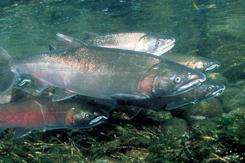
The Klamath Basin’s Chinook salmon and coho salmon serve a vital
role in the watershed.
Together, they are key to the region’s water management, habitat
restoration and fishing.
However, years of declining population have led to federally
mandated salmon restoration plans—plans that complicate the
diversion of Klamath water for agriculture and other uses.
This issue of Western Water examines the challenges facing state,
federal and tribal officials and other stakeholders as they work
to manage terminal lakes. It includes background information on
the formation of these lakes, and overviews of the water quality,
habitat and political issues surrounding these distinctive bodies
of water. Much of the information in this article originated at
the September 2004 StateManagement Issues at Terminal Water
Bodies/Closed Basins conference.
The story of the Klamath River is the story of two basins.
In the upper basin, farming has long been the way of life. Even
before passage of the 1902 Reclamation Act, settlers had begun
the arduous process of reclaiming vast tracts of wetlands and
transforming them into rich farmland.


 and temperature. This gauge near downtown Sacramento measures water depth. (Source: California Department of Water Resources)")
")


. Credit: U.S. Bureau of Reclamation")