Header link June 22, 2020

LinkedIn

  • Read more
Header link September 15, 2014

Cart

  • Read more
Header link November 3, 2015

Donate Now

  • Read more
Header link May 15, 2014

Twitter

  • Read more
Header link May 15, 2014

Facebook

  • Read more
Instagram
Header link May 15, 2014

Instagram

  • Read more
Header link May 15, 2014

Contact Us

  • Read more
More options
Water Education Foundation
Home

Water Education Foundation

Everything about California water that matters
  • Water Academy
    • Agriculture
      • Agricultural Conservation
      • Agricultural Drainage
    • Background Information
      • Legislation — California and Federal
      • Regulations — California and Federal
      • Water History
      • Water Rights
    • Bay-Delta
      • Bay Delta
      • Bay Delta Conservation Plan
      • Delta Issues
      • Delta Smelt
      • Sacramento San Joaquin Delta
      • San Francisco Bay
      • Suisun Marsh
    • Dams, Reservoirs and Water Projects
      • California Aqueduct
      • Central Valley Project
      • Folsom Dam
      • Friant Dam
      • Hetch Hetchy
      • Hoover Dam
      • Infrastructure
      • Lake Mead
      • Lake Powell
      • Oroville Dam
      • San Luis Dam
      • Shasta Dam
      • State Water Project
    • Environmental Issues
      • Anadromous Fish Restoration
      • Ecosystem
      • Endangered Species Act
      • Invasive species
      • Lake Tahoe
      • Mono Lake
      • Public Trust Doctrine
      • Salmon
      • San Joaquin River Restoration
      • Watershed
      • Wetlands
    • Leaders and Experts
    • Regions
      • Central Coast
      • Central Valley
      • Mexico
      • Nevada
      • North Coast
      • Pyramid Lake
      • Sacramento Valley
      • Salton Sea
      • San Joaquin Valley
      • Sierra Nevada
      • Southern California
      • Tulare Lake Basin
    • Rivers
      • Carson River
      • Colorado River
      • Klamath River
      • New River
      • North Coast Rivers
      • Russian River
      • Sacramento River
      • Truckee River
      • San Joaquin River
    • Water Issues
      • Climate Change
      • Coronavirus
      • Drought
      • Earthquakes
      • Energy and Water
      • Floods
      • Fracking
      • Growth
      • Hydropower
      • Levees
      • Tribal Water Issues
      • Water Conservation
    • Water Quality
      • Drinking Water
      • Nitrate contamination
      • Pollution
      • Stormwater
      • Wastewater
      • Water Quality
    • Water Supply and Management
      • Acre Foot
      • Aquifers
      • California Water Plan
      • Conjunctive Use
      • Desalination
      • Grey water
      • Groundwater
      • Integrated Regional Water Management
      • Recreation
      • Surface Water
      • Water Marketing and Banking
      • Water Rates
      • Water Recycling
      • Water Supply
      • Water Transfers
  • Tours & Events
    • Water Tours
      • 2024 Tour Sponsors
    • Events
    • Event Calendar
    • Past Tours & Events
      • Anne J. Schneider Fund Lecture Series
  • Specialized Programs
    • Water Leaders
      • Cohort Rosters
      • Yearly Class Reports
      • Your Alumni Network
      • Alumni Profiles
    • Project WET
      • Workshops
      • Special Workshops & Events
      • Supplementary Materials
      • California Content Standard Correlations
      • Facilitator's Trainings
      • Foundation School Programs
        • Elementary Programs
        • Secondary Programs
      • Water Kids
      • California Project WET Gazette
      • Gazette Archives
    • Colorado River Project
    • GRA Scholastic Fund Program
  • Maps & Guides
    • Maps & Posters
    • Layperson's Guides
    • Map & Guide Bundles
    • Books
    • Colorado River Materials
    • California Runoff Rundown
    • Other Publications
    • Water Awareness Materials
    • Downloadable Publications
    • Videos and DVDs
      • Video Clips
    • School Age Publications
    • Stickers
    • Free Programs and Publications
  • Newsroom
    • Western Water News
    • Aquafornia
      • About Aquafornia
    • Information Desk
    • Western Water Magazine Archive
      • Full Print Edition
      • Print Edition Excerpts
    • River Report Archive
  • Aquapedia
    • Alphabetical List of Subjects
      • A
      • B
      • C
      • D
      • E
      • F
      • G
      • H
      • I
      • J
      • K
      • L
      • M
      • N
      • O
      • P
      • Q
      • R
      • S
      • T
      • U
      • V
      • W
      • X
      • Y
      • Z
    • Historical Water People
    • Where Does My Water Come From?
      • Northern California
      • Sacramento
      • North Bay
      • South Bay
      • Central Valley
      • Los Angeles
      • Inland Empire
      • San Diego
      • All California Water Sources
    • Timelines
    • Videos
    • Image Gallery
    • Water Directory
      • Federal Agencies
      • State Agencies in California
      • Environmental Organizations
      • Other California Organizations
      • State and Federal Legislative Committees
      • Water Associations and Groups
      • Western States Water Agencies and Districts
    • Online Resources
    • Useful Acronyms
    • About Aquapedia
  • About
    • About Us
      • Board of Directors
      • Staff Biographies
      • Job Openings
    • Announcements
    • Support Our Mission
      • Become a Member
      • Donate in Honor/Memory
      • Planned Giving
    • Contact Us
Aquapedia background February 11, 2014 California Water Map Layperson's Guide to Groundwater

Tulare Lake Basin

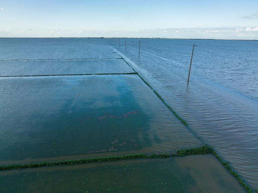
Image shows flooded crop fields in Tulare Lake Basin in 2023Until the early 1900s, Central California’s Tulare Lake appeared every winter as the southernmost rivers flowing out of the Sierra Nevada filled the dry lakebed with rainfall and melted snow.

In the spring, the shallow lake near Visalia could cover as much as 790 square miles or four times the surface area of Lake Tahoe. However, by the end of the hot San Joaquin Valley summer, the giant lake – once the largest freshwater body west of the Mississippi River – could disappear primarily due to evaporation.

Tulare Lake and its tule marsh complex that once dominated the Central California landscape are no longer featured on maps. The dormant lake reappears only during years of extreme precipitation in the central and southern Sierra, when dams on rivers that once fed the lake swell above their flood-control caps. The lake partly refilled in 1969, 1983, 1997, and again in 2023 when more than a dozen atmospheric rivers hit California.

In 2023, the revived lake caused widespread flooding of communities and farmland. The flooding was precipitated by heavy rainfall and meltwater from the largest snowpack ever recorded in the southern Sierra. The flooding caused billions of dollars in farming losses in parts of Fresno, Kern, Kings and Tulare counties.

History

Tulare Lake was originally home to the Yokuts, a group of Native American tribes that spoke similar languages and lived near the Kings, Kaweah, Tule and Kern rivers that fed the lake. For thousands of years, the tribes thrived in the basin’s diverse habitats, from wetlands and vernal pools to oak woodlands and riparian forests. The Yokuts enjoyed abundant wildlife and native fish, including pikeminnow, hitch and chinook salmon.    

The Tulare Lake Basin dramatically changed after the Gold Rush as miners left the mountains for the valley. The new settlers drove out the Indigenous communities, diverted the rivers and drained the marshes for farming. They built canals, levees and eventually dams, notably Pine Flat on the Kings River, Terminus on the Kaweah and Success on the Tule—robbing the lake of its water sources.

By the early 20th century, the basin had been transformed into one of the best cotton-growing regions in the nation. Today, the former lakebed hosts a wider variety of crops such as tomatoes, wheat and almonds but is best known for being one of the top-producing dairy regions in the nation.

Farm Drainage

The Tulare Lake Basin doesn’t have an outlet, so controlling salinity levels is critical to protecting the health of the soil and groundwater.
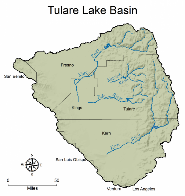
Map of Tulare Lake BasinFertilizers and livestock waste in farm drainage and irrigation water imported from the Sacramento-San Joaquin Delta contain salts that can render farmland less fertile and groundwater undrinkable. To lessen the damage, the runoff from nearly 50,000 acres of farmland is stored in a network of four evaporation catchments stretching across 5,250 acres, known as the North, South, Hacienda and MEB basins.

While the containment has improved crop production, the high concentrations of salt and other wastes pose risks to waterfowl and shorebirds.

The state’s Central Valley Regional Water Quality Control Board monitors Tulare Lake Drainage District as part of its job policing agricultural runoff. The district operates a 307-acre habitat restoration site to limit harm to waterbirds, primarily American avocets and black-necked stilts. It also manages a 305-acre area designed as a winter wetland for dabbling and diving ducks. The site is designed to facilitate flooding and draining at different rates to create a mosaic of habitats for these birds. 

Long-term solutions for the Tulare runoff don’t come easily. Some local drainage managers believe the best solution is to build a drain to the Pacific Ocean, but state regulators say the economic and environmental costs would be too high.

Land Subsidence

For decades, farms and communities in the more arid parts of California have overpumped groundwater, depleting it faster than it is replenished. The California Department of Water Resources (DWR) has designated several groundwater subbasins beneath the lakebed as “critically overdrafted,” including Tulare Lake, Tule and Kaweah subbasins.

Overpumping has caused water tables to drop, land to sink near roads and canals and decreased water quality basinwide. (See Land Subsidence.)

The Tulare Lake Basin is one of the fastest-sinking areas in the nation because of chronic overpumping by growers. Some places are sinking a foot a year, causing roads and canals to buckle. Subsidence caused the Friant-Kern Canal to lose 60 percent of its water-carrying capacity and a 33-mile section of the channel had to be rebuilt. 

In 2022, DWR determined that groundwater agencies in Kings County did not adequately address these problems in their Tulare Lake Groundwater Sustainability Plan. The local agencies revised the plan, but DWR rejected it again in 2023 and deemed plans for the Tule and Kaweah subbasins inadequate.

At a hearing in 2024, the State Water Resources Control Board voted unanimously to put the Tulare Lake subbasin on “probation” for failing to curb growers’ overpumping. It was the first time California officials had used their authority to intervene in a community to rein in groundwater depletion, as required under the state’s decade-old Sustainable Groundwater Management Act. 

The April 16, 2024 order could eventually lead to the state taking control of groundwater pumping in the severely depleted basin. Under probation, agricultural landowners in the area will be required to start reporting to the state how much water they pump from wells and paying fees based on how much they use.

Updated April 2024

  • Print-friendly

Referring Pages

Share this page

  • Share on Facebook
  • Share on Twitter
  • Share on LinkedIn
  • Sent to a friend.
Print-friendly

Related Links

Aquapedia background February 11, 2014 California Water Map Layperson's Guide to Groundwater
Maps & Posters April 17, 2014 California Water Bundle

California Water Map
Updated December 2016

A new look for our most popular product! And it’s the perfect gift for the water wonk in your life.

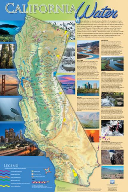
Our 24×36-inch California Water Map is widely known for being the definitive poster that shows the integral role water plays in the state. On this updated version, it is easier to see California’s natural waterways and man-made reservoirs and aqueducts – including federally, state and locally funded projects – the wild and scenic rivers system, and natural lakes. The map features beautiful photos of California’s natural environment, rivers, water projects, wildlife, and urban and agricultural uses and the text focuses on key issues: water supply, water use, water projects, the Delta, wild and scenic rivers and the Colorado River.

  • Read more
Publication May 20, 2014 California Groundwater Map

Layperson’s Guide to Groundwater
Updated 2017

The 28-page Layperson’s Guide to Groundwater is an in-depth, easy-to-understand publication that provides background and perspective on groundwater. The guide explains what groundwater is – not an underground network of rivers and lakes! – and the history of its use in California.

  • Read more
Back
This item appears in:
  • Tulare Lake Basin
  • T
Footer pod May 20, 2014

Water Education Foundation

Copyright © 2025 Water Education Foundation. All rights reserved.

The Water Education Foundation is a nonprofit, tax-exempt, 501(c)3 organization, federal tax ID #942419885.

Privacy Policy

Donor Privacy Policy

  • Read more
Footer pod May 20, 2014

Contact Information

2151 River Plaza Drive, Suite 205
Sacramento CA 95833

Telephone (916) 444-6240

Contact Us via email

  • Read more

Quicklinks

Footer quicklink May 20, 2014

Contact Us

  • Read more
Footer quicklink May 20, 2014

Donate Today

  • Read more
Footer quicklink May 20, 2014

Tours

  • Read more
Footer quicklink May 20, 2014

Newsletter Signup

  • Read more
Footer quicklink May 20, 2014

Foundation News

  • Read more
Footer quicklink May 20, 2014

Calendar

  • Read more

Log in

  • Create new account
  • Request new password

Commands

  • Support portal
  • Log in